Friday, March 2, 2012

General Update on Severe Weather & Tornado Outbreak...

This is one of those days where it's nearly impossible to "live blog" because there are so many simultaneous tornado events underway. I will focus in on particular storms as conditions warrant, otherwise I plan to start pulling together damage reports and photos and start posting those in groups.


Our thoughts and prayers are certainly with those who are suffering loss of life and property this afternoon across the Ohio Valley, Tennessee Valley and the South.  Unfortunately this situation looks to be just about as bad as we feared it would a couple of days ago...


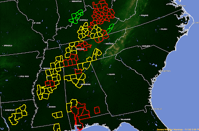
Currently there are too many tornado warnings to count...but I'll go ahead and tell you:  28 are in effect (as shown in red below)... along with 26 severe thunderstorm warnings (as shown in yellow):


Kentucky is absolutely getting clobbered, as you can see by the radar image from the Jackson, KY site below:


...and now that same image with Tornado Warnings overlain:


A wide view of the radar shows severe storms stretching from Ohio to Alabama, and moving Eastward:


Tornado Watches continue along and ahead of this activity through the evening, and more will follow:


Please continue to pay close attention to the weather if you live in the affected areas.  Have a sheltering location in mind and be ready to get there immediately if a warning is issued for your area.  Remember that the storms are travelling at 60+ mph, which will shorten your reaction time!


If you enjoy reading 'The Original Weather Blog', please be sure to "like" our facebook page!


Testing...

Having technical problems...testing...

Tornadic Supercell Entering Nashville Metro...


An extremely dangerous situation for Metro Nashville. A tornadic supercell, with a strong radar indication of a tornado, is moving East into the city at 65 mph.

Seek immediate shelter if you are in the path of this storm.  Get below ground if possible... otherwise, get into a small interior room or space on the lowest floor - away from windows.


If you enjoy reading 'The Original Weather Blog', please be sure to "like" our facebook page!

Tornado Photos Via Twitter...

Photos of tornadoes are flying across twitter right now, from Alabama all the way up to Ohio.  If you're studying for your mid-term exam in your online meteorology course, this would be a good time to take a break and check these out.

Here are some of the more noteworthy one's that I've seen so far.  Location and credit given where provided in the tweet:

Near New Market, AL - Adam Henry

Near Hunstville, AL - Dr. Harold Peterson

Borden, IN - Unknown 

Madison County, AL - Jason Simpson

"Southern Indiana" (likely near Borden) - Unknown

If you enjoy reading 'The Original Weather Blog', please be sure to "like" our facebook page!

Mid-Afternoon Severe Weather Update...

This is a "mobile" post, as I'm not currently at home base. Hope to be back soon to follow things more closely and provide more frequent updates.  This will be of special interest to people living in the Midwest, Ohio and Tennessee Valley region and the Deep South, as well as students taking weather classes from online universities.

Anyway, the severe weather and tornado outbreak continues to unfold, unfortunately, as we feared...  

There are numerous storms with active tornadoes in progress across the Ohio and Tennessee Valleys, into the Deep South:


In particular, the metro area of Louisville, Kentucky has severe, supercell storms with a history of tornadoes moving in from the West.  Please be ready to head to shelter in this area!  

Tornado Warnings are in effect for the counties in red, with severe thunderstorm warnings for the counties in yellow on the image below:


Folks in the Cincinnati and Nashville areas need to keep an eye to the West, with severe storms moving in your general direction...

This event will continue to spread East/Northeast across the Ohio, Tennessee Valleys and into the Deep South through late this afternoon and into this evening.

Tornado Watches continue for a large part of this region:


Please stay on alert across this region.  If you live ahead of this activity in an area that has yet to be affected, please take the time now to review severe weather sheltering tips and have a shelter in mind so that you can move there at once if severe weather approaches you.  

The storms today are moving very fast, at speeds of 60+ mph.  Depending on where you live in relation to the storms, you may have very little time to react if a warning is issued for your area...so be ready!


If you enjoy reading 'The Original Weather Blog', please be sure to "like" our facebook page!

Midday Update on Severe Weather & Tornado Outbreak...

As we feared, the situation is beginning to ramp-up severe weather wise across the Ohio and Tennessee Valley region, into the Deep South.  People taking meteorology classes from accredited online colleges will want to keep track of this system as well...

The image below is the latest regional radar, with an overlay of a severe weather forecasting tool/index known as the "Significant Tornado Parameter" (which is abbreviated STP).  


As you can see, there are two primary bands of strong to severe storms at present.  One stretching from Indiana and Illinois into extreme northeast Arkansas/southeast Missouri.  The other is exiting the extreme northeast corner of Alabama, stretching up into middle Tennessee.

The large fields of solid red lines between these two lines of storms is the problem.  An STP value of 2 or more is considered very favorable for strong or violent tornado development.  We are currently seeing values of 5 or even 6 across a large area from southern Illinois into Mississippi.  As severe storms move and/or develop into these areas during the next few hours, widespread severe weather, including numerous tornadoes, can be expected.

Tornado Watches continue across this region:


...and additional watches will likely be issued in between the above very soon. Check the SPC Watch page here for specific details as to the watch status.

There continues to be a high likelihood of widespread severe weather, including the possibility of long track, strong and/or violent tornadoes, across a significant area this afternoon and evening.  The areas at highest risk are within the lavender, red and black hatched areas on the following image:


If you live in or near these areas, remain on a high state of alertness this afternoon.  Review severe weather safety tips now, have a specific sheltering plan in place, and listen for later statements and warnings for your area via local media or another trusted source.  

Keep in mind that storms will be moving at 55-65 mph or faster today, which will allow very little room for reaction time in some cases.  If a warning is issued for your area, seek shelter immediately!

If you enjoy reading 'The Original Weather Blog', please be sure to "like" our facebook page!

Tornado Watches Issued...

The first Tornado Watches are now being issued. The first covers generally middle Tennessee into northern Alabama and is valid until 3pm CST:


...and the second covers much of southern and central Illinois, western and central Indiana, southwest Kentucky and southeast Missouri.  It is valid until 6pm CST:


Tornadoes, large hail and damaging winds are likely in both of these areas.  The latter watch contains the enhanced wording "This Is A Particularly Dangerous Situation..." with the possibility of destructive tornadoes.

For additional details on watches in your area, check the Storm Prediction Center page here.

Folks across the entire region should be on a high state of alert today.  Have a sheltering plan in mind and be ready to take immediate action if threatening weather approaches your area.

Another thing to keep in mind today is that storms will be moving very fast.  The general motion of most of the storms will be to the East/Northeast at 55-60 mph - and some could move even faster.  This means your reaction time will have to be very quick.  If a warning is issued for your area, seek shelter immediately.  This isn't a situation where you'll have time to evaluate the situation much further before taking action...


If you enjoy reading 'The Original Weather Blog', please be sure to "like" our facebook page!