This is one of those days where it's nearly impossible to "live blog" because there are so many simultaneous tornado events underway. I will focus in on particular storms as conditions warrant, otherwise I plan to start pulling together damage reports and photos and start posting those in groups.
Our thoughts and prayers are certainly with those who are suffering loss of life and property this afternoon across the Ohio Valley, Tennessee Valley and the South. Unfortunately this situation looks to be just about as bad as we feared it would a couple of days ago...
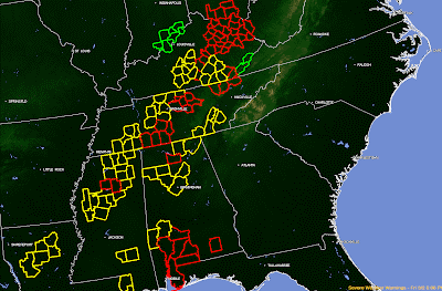
Currently there are too many tornado warnings to count...but I'll go ahead and tell you: 28 are in effect (as shown in red below)... along with 26 severe thunderstorm warnings (as shown in yellow):
Kentucky is absolutely getting clobbered, as you can see by the radar image from the Jackson, KY site below:

...and now that same image with Tornado Warnings overlain:


Our thoughts and prayers are certainly with those who are suffering loss of life and property this afternoon across the Ohio Valley, Tennessee Valley and the South. Unfortunately this situation looks to be just about as bad as we feared it would a couple of days ago...
Currently there are too many tornado warnings to count...but I'll go ahead and tell you: 28 are in effect (as shown in red below)... along with 26 severe thunderstorm warnings (as shown in yellow):

Kentucky is absolutely getting clobbered, as you can see by the radar image from the Jackson, KY site below:

...and now that same image with Tornado Warnings overlain:

A wide view of the radar shows severe storms stretching from Ohio to Alabama, and moving Eastward:

Tornado Watches continue along and ahead of this activity through the evening, and more will follow:

Please continue to pay close attention to the weather if you live in the affected areas. Have a sheltering location in mind and be ready to get there immediately if a warning is issued for your area. Remember that the storms are travelling at 60+ mph, which will shorten your reaction time!
If you enjoy reading 'The Original Weather Blog', please be sure to "like" our facebook page!
No comments:
Post a Comment