A tornado touched down near the community of Dodson Branch in southeastern Jackson County, TN at approximately 5:26 pm CST on Friday, March 2, 2012. The tornado continued on the ground for 11.3 miles before lifting approximately 4 miles North of Rickman in rural southwestern Overton County, TN at approximately 5:35 pm CST.

The maximum path width was one-half mile, and this tornado was rated EF-2 intensity, with maximum winds estimated at 125 mph. There were no fatalities and 3 injuries (in Dodson Branch) associated with this tornado.

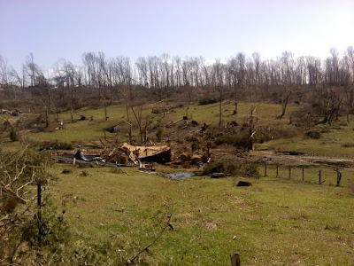
Approximately 20-25 homes were damaged in Dodson Branch, with 15-20 damaged or destroyed in rural Overton County. Most of the photos of damage, below, are from the Dodson Branch area:


Approximation of the EF-2 tornado track
The maximum path width was one-half mile, and this tornado was rated EF-2 intensity, with maximum winds estimated at 125 mph. There were no fatalities and 3 injuries (in Dodson Branch) associated with this tornado.

Tornado near Dodson Branch - Unknown Photographer
Approximately 20-25 homes were damaged in Dodson Branch, with 15-20 damaged or destroyed in rural Overton County. Most of the photos of damage, below, are from the Dodson Branch area:


Note: post was updated 3-16-12 to add a photo of the actual tornado (near the top of the post).
This tornado was just one of many associated with the outbreak that took place across the Midwest, Ohio and Tennessee Valley region on Friday, March 2, 2012. Please see this post for a "Table of Contents" index listing of the other Tornado Chronicles posts associated with the outbreak.
If you enjoy reading 'The Original Weather Blog', please be sure to "like" our facebook page!
2 comments:
Thank you for posting this information. It is lovely that someone is out there taking the time to educate people about weather conditions. I like this post...most informative posts have very few pictures, and this one have excellent imagery on the goings-on.
However, I believe you may be a little mistaken in your tornado path map. I live in Dodson Branch...and there are actually 2 Dodson Branch Highways...the old one (which I live on and is East of the new one at the point of touchdown) and the new one which also goes by 135.
The tornado actually extended across the new Dodson Branch Hwy towards Old Dodson Branch, the end was approximately where Willis Martin (North of the tornado) has a 90 degree bend. Your map shows it stopping at Dodson Branch Hwy
I'm sure it doesn't really matter I just thought I'd share
Anonymous,
Thanks for the comment. I'm glad that you find the blog useful and informative...I appreciate it!
The mapping is based on the National Weather Service (NWS) survey data. They provide latitude and longitude points that are plotted on a map program (like Google Maps, etc.).
I typically check the survey data for any revisions for a month or two after the event (the path data doesn't normally change after that period of time, even though you may come across new photos, video, etc).
I will check the ending points for any updates and will be sure to revise the post accordingly...
Thanks again!
Rob
Post a Comment