
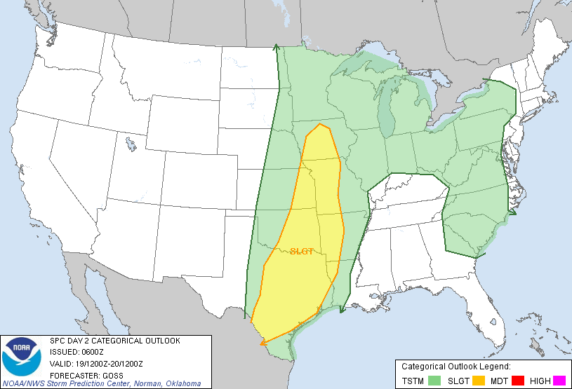
Severe Weather Outlook for This Afternoon and Tonight
Above is the latest severe weather outlook for this afternoon and tonight from the SPC in Norman, OK. Severe storms are forecast within the yellow shaded areas on the above image. This threat of severe weather includes the cities of Dodge City, Garden City, Russell, Hays, Great Bend, Hutchinson, Woodward, Enid, Altus, Lawton, Abilene, Wichita Falls, Childress and San Angelo.
A strong middle and upper level storm system is approaching the Rockies from the southwest this morning. This system will eject disturbances into the adjacent High Plains later today and into tonight. These disturbances will interact with increasing moisture and instability at the surface and result in thunderstorm development along and ahead of a dryline extending from southwest Nebraska into southwest Texas.
Large hail, damaging wind gusts and a few tornadoes can be expected with severe storms that form in this region later today and into tonight. The highest risk of severe weather, including hail in excess of 2 inches in diameter, is located within the black hatched areas on the image below:

Significant Severe Weather Possible Black Hatched Area
Thunderstorms are initially likely to develop by late afternoon and early evening along and ahead of the dryline - on a scattered basis. Large hail, damaging winds and a few tornadoes can be expected with this activity during the late afternoon and evening hours today. This activity may diminish after sunset due to the loss of daytime heating.
Another round of storms will likely develop during the pre-dawn hours of Monday across much of the same area, as a stronger piece of energy is ejected from the upper-level storm system. This activity would likely form into more of a solid line, with damaging wind gusts and hail the primary threats (although a tornado threat cannot be completely ruled out overnight either).
By Monday, the severe weather threat will shift Eastward and increase in both coverage and intensity as several pieces of energy are ejected from the approaching middle and upper level storm system. Severe storms are forecast Monday within the yellow shaded areas on the image below:
Severe Weather Outlook for Monday Into Monday Night
Thunderstorms are likely to be ongoing at sunrise on Monday near the Western portions of the severe weather outlook area above. Some of this activity may be strong to severe despite the time of day, with hail and wind gusts the primary severe threats early on Monday.
By Monday afternoon and into Monday evening, activity is likely to reorganize and intensify along and ahead of a cold front, with the highest potential for severe weather extending from southeast Oklahoma and southwest Arkansas, southward into central and eastern Texas, near the red and black hatched areas on the image below:

Significant Severe Weather Possible Red and Black Hatched Area
Very large hail (some up to 2 inches in diameter or greater), damaging wind gusts and a few tornadoes are possible with activity in this region on Monday afternoon and evening. This enhanced threat of severe weather on Monday afternoon and evening includes the cities of Dallas, McAlester, Ft. Smith, Texarkana, Lufkin, Shreveport, and the Austin/San Antonio corridor along I-35.
The severe weather threat is likely to extend Eastward into Arkansas, Louisiana and southeast Texas during the overnight hours Monday and the pre-dawn hours of Tuesday morning.
Very heavy rainfall will also be a threat across much of the above area, particularly during the period tonight through Wednesday morning. Below are the latest rainfall forecasts from the HPC for the 24-hour periods specified below each image:

Average Rainfall 7am Sunday to 7am Monday

Average Rainfall 7am Monday to 7am Tuesday

Average Rainfall 7am Tuesday to 7am Wednesday
Flooding and/or flash flooding will be a risk across much of this region, particularly within the darker red and purple shaded areas where daily rainfall amounts may exceed 2 inches in many locations.
If you live across any of the above severe weather outlook areas, please remain alert today and/or Monday. Listen to local media or another trusted source for the latest updates, watches and warnings. Take the time now to review severe weather safety and preparedness tips and make sure that you and your family have a safe sheltering location ready to go if threatening weather is observed or a warning is issued.
If you enjoy reading 'The Original Weather Blog', please be sure to "like" our facebook page!
No comments:
Post a Comment