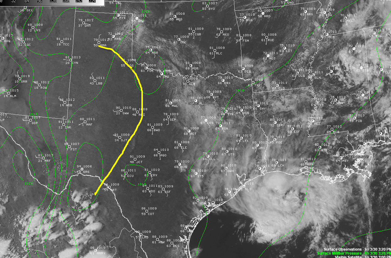
The above visible satellite picture was taken just a few moments ago. I have drawn the location of the surface dryline in yellow. To the West of the boundary, the temperature has risen into the mid 90s over southwest Texas, with dew point temperatures only in the single digits or teens (further signifying the very dry air that is in place behind the boundary). To the East of the dryline, dew point temperatures are in the 50s and 60s.
The strong difference in moisture profile across the boundary is leading to convergence, which may allow for thunderstorm development over the next few hours along and ahead of the boundary. You can see a large field of cumulus clouds bubbling up ahead of the boundary over southwestern Oklahoma, and if you look closely, you can also see a small line of towering clouds beginning to develop along the dryline to the southwest of Brownwood, Texas.
If thunderstorms are able to develop along and ahead of the dryline late this afternoon or this evening, very large hail will be likely, as shown within the yellow and black hatched area on the image below:

The main limiting factor at this time is the presence of a strong capping inversion across the region. The convergence will have to become strong enough along the dryline in order for a thunderstorm to break through the cap, develop and become severe. It is possible that some weak energy in the upper atmosphere may also over over this region late this afternoon or early this evening and assist in a few storms breaking the cap as well.
Folks living within the yellow shaded and black hatched area on the above image should remain alert to any thunderstorm development later today. While the probability of a storm developing is not necessarily high, any storm that does form will almost certainly become severe due to the high amount of instability that is in place across this region.
Elsewhere, severe thunderstorms are currently developing (as we had expected in the morning outlook) over the Midwest and Ohio Valley, where a couple of Severe Thunderstorm Watches are already in effect.
If you live in any of the above mentioned areas, please remain on the alert this afternoon and into this evening. Review your severe weather safety tips and be sure to identify the best sheltering option for you and your family at home, work or school.
Are you new to the blog? Welcome! Please click on the icons below to "Like" my facebook page and/or follow me on twitter. You'll find posts at these locations that aren't always on the blog, especially during rapidly changing weather situations...


No comments:
Post a Comment