Showing posts with label Tropical Storm Arlene. Show all posts

Thursday, June 30, 2011

Tropical Storm Arlene Making Landfall in Mexico


At 7am CDT, the center of Tropical Storm Arlene was located along the Mexican coast near Cabo Rojo.  Maximum sustained winds were estimated at 65 mph, and the minimum central pressure was 29.32 inches of mercury.


Arlene is moving West at 8 mph, and will continue on this general motion as she progresses into Mexico today and tonight.  Very heavy rains and strong, gusty winds can be expected well inland across Mexico through Friday:


Bands of rain and thunderstorms, some heavy, continue to stream along the Northern edge of Arlene into the Brownsville, McAllen and adjacent portions of  Deep South Texas this morning:


This trend will continue today, with up to 2 inches of rain possible in heavier showers.   The heaviest rains, which will exceed 6 inches in some areas, will take place South of the border into Mexico:


If you enjoy reading 'The Original Weather Blog', please be sure to "like" our facebook page!


Wednesday, June 29, 2011

Arlene's Winds up to 60 MPH...


At 5pm CDT...a Hurricane Hunter aircraft measured sustained near-surface winds of 60 mph in association with Tropical Storm Arlene.  The center of the system was located about 120 miles East of Tuxpan, Mexico, and moving West at 7 mph.  Minimum central pressure was measured at 29.41 inches of mercury.

The Government of Mexico has issued a Hurricane Warning from Barra De Nautla to La Cruz.  This replaces the Tropical Storm Warning and Hurricane Watch that was previously in effect.

The latest radar image from the Alvarado, Mexico radar is below, and gives us a nice look at the southern-most precipitation bands associated with Arlene:


During the afternoon, bands of thunderstorms and showers have clipped the extreme southern tip of Texas, near the Brownsville area, in association with the northern-most extent of Arlene.  According to the latest Brownsville radar image (below), additional showers and thunderstorms will continue to brush far South Texas later this evening & into tonight as Arlene begins to make landfall well to the South in Mexico:


The official National Hurricane Center forecast (below) continues to keep Arlene below Hurricane force through landfall, but there is still a chance that the system could arrive along the central Mexican coast as a minimal hurricane on Thursday morning.


If you enjoy reading 'The Original Weather Blog', please be sure to "like" our facebook page!

Tropical Storm Arlene Continues Toward Mexico...


At 10am CDT, the center of Tropical Storm Arlene was located about 155 miles East/Southeast of Tampico, Mexico, and moving West at about 8 mph.  Maxiumum sustained winds are estimated at 50 mph, and the minimum central pressure was 29.53 inches of mercury.

Some additional strengthening is forecast as Arlene continues on a general Westward path over the next 24 hours.  The following forecast track from the NHC still shows Arlene remaining at Tropical Storm force through landfall, however she may reach minimal hurricane force prior to making landfall:


The government of Mexico has issued a Hurricane Watch from Tuxpan to La Cruz.  A Tropical Storm Warning remains in effect from Barra De Nautla to Bahia Algodones.

Very heavy rain, strong, gusty wind and dangerous surf can be expected along the central Mexican coast through tomororw.


If you enjoy reading 'The Original Weather Blog', please be sure to "like" our facebook page!

Tuesday, June 28, 2011

Invest 95 Declared "Arlene" - First Tropical Storm of Atlantic Season


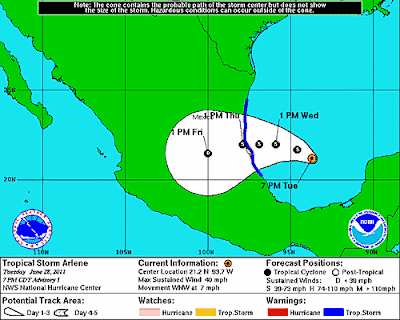
Tropical Storm Arlene has formed in the extreme southern Gulf of Mexico.  At 7pm CDT, the center of Arlene was located 280 miles East/Southeast of Tampico, Mexico, and was moving West/Northwest at 7 mph.  Maximum sustained winds were estimated at 40 mph.


The official NHC forecast track is shown below.  At this time, Arlene is not expected to reach hurricane strength before making landfall along the Mexican coast on Thursday afternoon:


See this recent post for additional information.


Like this blog?  Please "like" our facebook page!

'Invest 95' About to Become a Depression... or 'Arlene'...


An Air Force Hurricane Hunter aircraft investigated the area of disturbed weather (dubbed "Invest 95") in the Bay of Campeche this afternoon.  While they did find a closed circulation (an area of low pressure), they did not find a core of sustained winds strong enough to classify the system as a Depression.    This is likely due to the fact that middle & upper level winds are still causing some shear over the system, preventing it from fully organizing.  That condition, however, is expected to change over the next 12 hours, which will allow the system to undergo some fairly rapid organization.

Below is the latest image from the nearby Alvarado, Mexico radar:


You can see some of the outer feeder bands of precipitation beginning to flow Westward into the radar's view.  The center of the system is off to the right (or East) of the image.

The system continues to maintain a slow West/Northwestward drift, and this motion is expected to continue for the next few days.  Below is the latest computer model forecast track of the system over the next 3-5 days, which continues this same general motion:


It is quite likely that the system will become at least a depression during the next 12-24 hours.  If surface winds become sustained at 39 mph or higher, we could jump right into Tropical Storm Arlene - which would be the first named storm of the 2011 Atlantic Season.

Regardless of the eventual classification of the system, very heavy rains and gusty winds will continue to be produced across portions of Central America and the Mexican coast (particularly the Mexican states of Tamaulipas and Veracruz) over the next few days.


Tropical "Invest 95L" Slowly Organizing...

In a post yesterday evening, I commented on a tropical disturbance that had flared up over parts of Central America & southeast Mexico.  


As of midday today the system continues to slowly try to get organized (as noted by the white circled area on the above satellite image).  It continues to drift very slowly toward the West/Northwest.

The National Hurricane Center (NHC) plans to send a "Hurricane Hunter" aircraft into this system later this afternoon to investigate and see if the system has developed any organized circulation or low pressure center.

Computer forecast models continue to develop the system over the next few days, and keep it on a general West/Northwestward track:


We'll provide more updated information later today as data flows in from the NHC aircraft.


Monday, June 27, 2011

Tropics Flaring Up?


The above satellite image was taken just a moment ago.  The red circled region on the image denotes a tropical disturbance over the Eastern part of the Bay of Campeche.  This system is currently dubbed "Invest 95L".  (For more information on the various stages of tropical system classification, see a recent post here).  It is drifting very slowly toward the West/ Northwest - a motion that is expected to continue for the next few days.

A "Hurricane Hunter" aircraft is scheduled to visit this disturbance tomorrow if it continues to slowly organize overnight.  Right now, middle & upper-level conditions are not favorable for rapid development, however that will change over the next few days, with more favorable conditions for development possible by Wednesday.

Very heavy rains and gusty winds will continue across portions of southeastern Mexico and much of Central America for the next few days as this system drifts slowly West/Northwestward.

Computer forecast models are currently keeping the system on a general West/ Northwestward track for the next 5-7 days, as shown on the latest composite computer model forecast image below:


Keep in mind that errors in the computer models can be quite large beyond the 2-3 day timeframe with this type of developing/infancy stage system, so take the above image "for what it's worth..."