Wednesday, October 20, 2010

Active Weather Still on the Way

Please see yesterday's post for more on what we're doing this week.

With the above in mind, here is the latest GFS Model forecast for 7pm CDT Wednesday, 10-27-10:


And here is what the same model had forecast for the same valid date and time 2 days ago (issued and posted on Monday):


As you can see by the latest model run (top image), compared to the prediction on Monday (and again yesterday), the models are now limiting the Southward progression of the cold front, but actually depict an even more active pattern in the middle atmosphere as far as disturbances are concerned.

Since this is the first "departure" from the original forecast of Monday and Tuesday, it would be wise to evaluate the computer model runs over the next day or two and see if the current trend is continued, or if the models revert back to the original prognosis. 

In either case, it continues to appear as though we are in store for a very active week weather-wise for next week...


Tuesday, October 19, 2010

Long Range Update

In my post yesterday, I pointed out how a major pattern change would begin this week, continuing into the last week of the month and 1st week of November.  I used, in part, the 240 hour forecast from the GFS Model as a basis for this prediction.  I thought it would be interesting to post a comparison each morning this week to see how the computer model forecast changes/evolves for the same valid date and time.

Since yesterday's long-range point of reference was the forecast valid at 7pm Wednesday, 10-27-10, we'll continue to use that in our comparison this week.

First, here is what the GFS Model was forecasting yesterday.  Again, remember, the valid time of this prediction is 7pm Wednesday, 10-27-10:


Now, here is what the same forecast model is forecasting 24-hours later, for the same valid time of 7pm CDT Wednesday, 10-27-10:


As you can see, this particular computer model is still forecasting a strong surge of cold air blasting southward through the Plains during the 2nd half of next week.  The strong upper-level low over the Southwest U.S. is also still depicted as in the previous model run.

If anything, this latest run of the computer model is forecasting the cold front to be a little further south than in the previous run, near the Red River between Texas/Oklahoma by 7pm on Wednesday the 27th.

This is something we look for in meteorology called "continuity" with respect to the models.  Basically, when each new run of the forecast model generally continues to come up with the same conclusion for the same general area and/or period of time, you can assume that the liklihood of the event(s) actually happening is higher.

We'll continue to post the subsequent GFS Model runs for the same valid time throughout the week and see if this trend continues.  For now, it certainly is safe to say that our prediction yesterday of a colder, more active end to October is certainly on track...

Monday, October 18, 2010

Southern Plains Weather To Become Active Again

After a week to 10 days of nearly non-existent (but beautiful) weather, a major pattern change is underway in the atmosphere that will bring much more active weather to the southern Plains (and much of the remainder of the nation for that matter) over the coming 2 weeks.  This is to be expected during the 2nd half of October and 1st part of November, so it's nice to see things moving along the meteorological calendar "on schedule" for a change...

If you live in central or south Texas, you've probably noticed the first element of this change this morning:  FOG.  As noted on the 7:43 a.m. surface map from this morning, dense fog is widespread across much of central & east Texas, into adjacent portions of Oklahoma, Louisiana and Arkansas (note the purple symbol that looks like a large equal sign "=", which depicts the observance of fog at the appropriate stations):


The development of widespread fog is indicative of low-level moisture surging back Northward from the Gulf of Mexico.  This moisture return will be an important ingredient in producing rain across the region on an increasing basis over the next week to 10 days.

The second part of the pattern change has to do with wind flow and disturbances in the middle & upper levels of the atmosphere.  Below is the latest computer forecast from the GFS Model, valid at 7pm CDT tomorrow evening, 10-19-10:


Note the panel on the upper left side of the 4-panel image.  This panel shows the expected wind flow at 500mb, which meteorologically speaking roughly corresponds to the "middle" of the atmosphere.  (For a more detailed tutorial on what each panel means and how to interpret the information, go here).

Note the large swirling area of low pressure over the southwest U.S.  This area of low pressure will begin ejecting disturbances to the Northeast into the southern Rockies & Plains this week, bringing increasing chances of precipitation.  Note the latest forecast rainfall map for today through Friday from the HPC:

By Friday, the low is expected to lift out into the Plains, bringing an even more widespread rain event (including an increasing potential for severe storms) to the region at that time:


Also note in the above image (which is the GFS computer model forecast valid at 7pm Friday, 10-22), that yet another piece of energy is already forming back over the Southwest where the original low pressure area had formed earlier). This suggests that an active pattern will continue even after the main low pressure area is ejected out to the Northeast later in the week.

Looking even further ahead, an even more vigorous scenario is forecast next week.  Below is the 240 hour forecast from the GFS Model, valid 7pm CDT Wednesday, 10-27-10:


Note another, even stronger, area of low pressure forecast over the same region in the southwest U.S.  Perhaps even of more interest is the very strong, arctic cold front that is forecast to be surging Southward into the Plains at about the same time (note the upper right panel in the same 4 panel image, which shows the forecast conditions at the surface level).

If this latter scenario verifies, it will be the first significant arctic cold front of the season to impact the U.S.  240 hours is obviously a long ways out, and a lot can change in the meantime, but it definitely bears watching.

Regardless of how all of the above scenarios actually pan-out, the bottom-line is that we're definitely going to see a return to a more active weather pattern over the coming week to 10 days.  Stay tuned!

Sunday, October 10, 2010

Severe Weather Potential Today & Monday


The above radar image was taken by the doppler radar at Vance AFB (near Enid, OK) just a few moments ago.  You can see fairly widespread shower & thunderstorm activity over southern Kansas and northwestern Oklahoma.  This activity is occurring ahead of an  upper level weather disturbance that is lifting East/Northeast out of Colorado this morning.


This disturbance is just the first in a series that will rotate around a broad area of low pressure currently located over western Nebraska (as seen in the latest watervapor satellite image below) over the next few days.


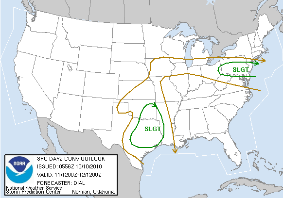
The combination of the disturbances along with a gradual return in low level moisture and instability will result in a risk of severe thunderstorms across portions of the central & southern Plains today and again on Monday.  Please note the SPC severe weather risk areas as forecast for today:


and Monday:


Each year it's pretty typical for there to be a "secondary" or mini severe weather season during the transition from summer into fall and winter in the Plains.  During this time of year, there is usually no shortage of frontal boundaries and upper air disturbances as cooler Polar air drives Southward.  The trick, at least insofar as severe weather development is concerned, can be getting enough low-level moisture and instability into the affected areas to support widespread severe weather.  

As you can see by the 10:30 am CDT surface map below, dew points are still only in the 40s to lower 50s in today's severe weather risk area.  However, you can see 60s dewpoints not too far to the south in Texas, and this moisture will gradually spread Northward today & tonight.


Just in case you're new to surface map reading (or new to the format above), here is a simple graphic that will help you to decode the information:

Thursday, October 7, 2010

Media Disappointed With Hurricane Season


Get ready for news articles, like this one, blasting forecasters as not knowing what they were doing earlier this year when forecasting an above average hurricane season.  The fact of the matter is, it has certainly been an above average season.

I know we tend to be a bit self-centered at times, but just because the U.S. coast wasn't hammered by a powerful storm doesn't mean that the season hasn't been above average as far as activity goes.  So far we've had 15 named storms in the Atlantic Basin this season.  This compares to 10 on average to date.  It just so happens that the majority of the storms have remained out to sea and did not impact heavily populated land masses. 

You'd think we'd be grateful for such an outcome as the end of an active season nears.  Sometimes I think the media is just too locked-in on "disaster watch" to see the big picture...

Saturday, October 2, 2010

Severe Weather In Southern CA


The above radar image was taken from the Yuma, AZ radar just a few moments ago.  A Severe Thunderstorm Warning was recently issued for portions of Imperial County, California (noted by the red warning box on the image above).

Today is one of those relatively rare days in southern California where several parameters are in place for strong to severe storms.  Low-level moisture is relatively high for the area, as noted by the 60 degree dewpoints outlined by the green contours on the image above.

As is typical for the region, lightning content of this activity will be very high (see same radar image as above with lightning overlaid in the next image below):


Tropics As Advertised...Sort of


In a post last Sunday I outlined what (at the time) the latest computer forecast model solutions were indicating for the Yucatan region this weekend.  This included what the computers were suggesting would be a rather strong tropical system developing off of the Yucatan Peninsula by Sunday (tomorrow) evening.


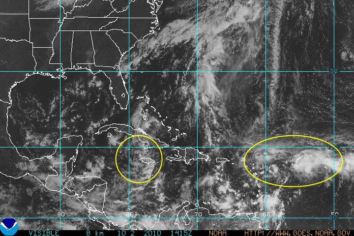
Well, as you can see by the satellite image (taken a few moments ago) above, there is indeed a tropical disturbance approaching the Yucatan region (yellow encircled area in the lower left quadrant of the image), but so far it is not nearly as strong as was indicated by the models last weekend.  Conditions aren't currently very favorable for strong organization or intensification of this system, however it will need to be monitored over the next 24-36 hours.


At this point in time, that's about all the computer models are good for as far as "medium range" forecasting in the tropics is concerned.  They do a pretty good job at letting you know of general areas to watch at a given point in time, but don't always have success at pinning-down the details.


Another, stronger, area of disturbed weather is located near and East of the Leeward Islands in the Eastern Atlantic (the 2nd yellow encircled area on the lower right side of the image).  This system has a slightly greater chance of further development as it moves Westward over the next 24-48 hours.