Friday, October 12, 2012

Significant Round of Severe Weather Likely on Saturday...

A powerful middle and upper level storm system will move out into the Plains on Saturday, causing a potentially widespread round of severe weather across portions of the central and southern Plains and into the Midwest.

The latest severe weather outlook for Saturday from the Storm Prediction Center (SPC) is shown below:


In general, severe thunderstorms are forecast anywhere within the brown and yellow shaded areas on the image, beginning in the West and spreading to the East with time.  Severe weather is forecast to become the most widespread, and likely the most significant with respect to intensity, within the red shaded area on the same image.

By late afternoon or early evening, severe thunderstorm activity will be well underway from central and eastern Iowa to the Kansas City Metro area, back into eastern Kansas and central and/or eastern Oklahoma.  Isolated to scattered severe storms will also extend Southward along the pre-frontal trough/dryline feature into western Texas.

At this time it appears that the most potent severe weather threat for Saturday afternoon and evening will extend from portions of central and eastern Oklahoma into eastern Kansas, western Missouri and much of Iowa.  This includes the cities of Oklahoma City (early in the period), Tulsa, Joplin, Kansas City and Des Moines:


Within this region, storms will initially be scattered in nature at midday or early afternoon, with a threat for large hail and tornadoes, a few of which could be strong and/or have longer than normal track lengths.  As the episode progresses, the activity will likely congeal into one or more solid lines, with a pronounced threat of potentially widespread damaging winds from late afternoon into the evening hours as the activity moves toward the East.

Further to the South and Southwest, isolated to scattered severe storms can be expected along a dryline in northwest and west-central Texas on Saturday afternoon.  This activity will move Eastward into the DFW Metroplex by Saturday evening.  Large hail, damaging winds and an isolated tornado or two are possible in this region.

Additional thunderstorm development is likely to take place into southwestern Texas and the Big Bend region on Saturday afternoon and evening.  This activity likely congeal into one or more larger complexes of storms that will move East and Southeast toward the I-35 corridor in central and southcentral Texas by Saturday night and early Sunday morning.  One or more of these complexes could impact the Austin-San Antonio area toward or just after dawn on Sunday morning.  Locally heavy rainfall will be the primary threat by that time.

In addition to the severe weather threat, widespread rainfall amounts of 1-3 inches are forecast across much of the region in association with this storm system and surface front.  Below is the latest rainfall forecast from the HPC valid 7am CDT today through 7am CDT Monday:
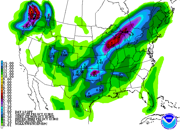

One of the higher resolution computer models is forecasting several swaths of  2-4 inch rains across Oklahoma, Kansas and Missouri, as well as west-central Texas.  The image below is the cumulative rainfall forecast from that model, valid 7am CDT today through 7am CDT on Sunday:


If you live in the severe weather threat areas for Saturday, please pay particular attention to the weather.  Listen to NOAA Weather Radio, local media or another trusted source for the latest information, watches and possible warnings.  

Take the time in advance to make sure your severe weather safety kit is prepared and/or re-stocked, and be sure to identify your best sheltering options so that you can move there quickly if need be.

For more information from 'The Original Weather Blog', including shorter, more frequent posts during rapidly changing weather events, please be sure to follow Rob on facebook and twitter:
 

If you are in need of customized, site specific weather forecasts or storm warnings for your company or event, be sure visit Rob's professional webpage at WeatherGuidance.com.


Severe Weather Threat on the High Plains Today...


A very strong upper-level low pressure system is currently centered to the West of Las Vegas, as shown on the water vapor satellite image above.  This system caused flash flooding and spotty severe weather over southern California as well as portions of Nevada and Arizona yesterday and overnight.  

Several disturbances will continue to flow around the base of the system today, moving out into the adjacent High Plains to the East of the Rockies (as shown by the purple arrows).  These disturbances will interact with increasing low-level moisture and instability to produce a threat of severe weather.

The greatest chance of severe weather this afternoon and evening is expected to extend from southwest Texas, Northward along the New Mexico and Texas border, into southwestern Kansas, as shown by the yellow shaded area on the image below:


Thunderstorms that form in this region later today and into this evening and early tonight will be capable of producing large hail, damaging winds and even a few tornadoes.  The greatest risk for a tornado will be located within the brown shaded area on the following image:


As we expected yesterday, thunderstorm activity formed overnight and early this morning along the Kansas/Oklahoma border, Eastward into southern Missouri and northern Arkansas.  This activity is currently moving Southeastward, as shown by the composite radar image shown below:


Some of this activity may strengthen during the midday and early afternoon hours as it approaches a moist, unstable airmass over southeastern Oklahoma and southern Arkansas.  Strong wind gusts would be the primary threat with this activity.

The main threat of severe weather today will develop later this afternoon and into this evening back to the West along a dryline near the Texas/New Mexico border, on Northward into the Oklahoma panhandle and southwest Kansas.  This threat will mainly take place after 2-3pm today, with all modes of severe weather (large hail, damaging winds and a few tornadoes) possible in this region.

If you live in the severe weather threat areas for today, please remain alert and listen for later forecasts, watches and warnings.  Take a few moments early in the day to identify your best sheltering option and be prepared to move there quickly if threatening weather is observed or a warning is issued.

For more information from 'The Original Weather Blog', including shorter, more frequent posts during rapidly changing weather events, please be sure to follow Rob on facebook and twitter:
 

If you are in need of customized, site specific weather forecasts or storm warnings for your company or event, be sure visit Rob's professional webpage at WeatherGuidance.com.

Thursday, October 11, 2012

Severe Weather Threat to Begin Tonight; Increase Into Weekend...


Southerly winds are transporting moisture from the Gulf of Mexico Northward in earnest today, as you can see by examining the latest surface wind and dew point analysis shown above.  This moisture will interact with a strong upper level storm system and surface cold front to produce several rounds of severe weather across the Plains and Midwest, beginning as early as tonight.

The latest severe weather outlook for tonight from the Storm Prediction Center (SPC) in Norman, OK is shown below:


Severe storms are possible within the brown shaded area from eastern New Mexico across the Oklahoma and Texas panhandle region, on Eastward into southern Missouri and northern Arkansas.  The highest risk of severe storms is located within the yellow shaded area across northern Oklahoma, extreme southern Kansas and adjacent portions of southern Missouri and northern Arkansas.

Thunderstorm activity is forecast to develop and increase across this region overnight tonight, mainly after 10pm-Midnight, and continue into the pre-dawn hours on Friday.  Large hail will be the main threat with this activity as storms develop on the nose of the strong moisture and instability stream that will continue flowing up into the region from the South.

By Friday afternoon and evening, a more significant threat of severe weather is forecast to develop across the High Plains from southwest Texas into central and eastern Nebraska.  The highest risk is within the yellow shaded area on the image below:


Large hail, damaging winds and a few tornadoes are possible across the severe weather outlook area for Friday afternoon and evening.

On Saturday, a regional outbreak of severe weather is still expected across portions of the central Plains and Midwest.  The latest outlook from the SPC is shown below:


The greatest risk of severe weather on Saturday will be located within the red shaded area on the image.  Scattered severe storms are possible within the yellow shaded areas, and more isolated activity within the brown shaded areas.

Large hail, damaging thunderstorm winds and tornadoes are likely with severe storms that develop on Saturday.  A few of the tornadoes could be strong and/or long track, especially within the red shaded area on the above image.

The severe weather threat on Saturday may begin as early as mid to late morning along the Western edge of the outlook area, especially over western Iowa, northwestern Missouri and northeastern Kansas.  The threat will then progress East/Northeastward throughout the afternoon while also gradually developing Southward.

If you live or have travel plans across the areas outlined above, please pay particular attention to the weather on the days and times indicated.  Make sure to identify your best sheltering option and be prepared to move there quickly if threatening weather is observed or a warning is issued.

For more information from 'The Original Weather Blog', including shorter, more frequent posts during rapidly changing weather events, please be sure to follow Rob on facebook and twitter:
 

If you are in need of customized, site specific weather forecasts or storm warnings for your company or event, be sure visit Rob's professional webpage at WeatherGuidance.com.

Wednesday, October 10, 2012

Update on Severe Weather Threat for Friday and Saturday...


A strong upper-level low pressure system swirling just off the California coast this morning will move Eastward over the next few days, bringing several rounds of severe weather to the Plains, Midwest and Ohio through Mississippi Valley Region toward the end of this week and into this weekend.

The latest severe weather outlook from the Storm Prediction Center (SPC) for Friday is shown below:


Isolated to widely scattered severe storms are forecast within the brown shaded areas on the image, with scattered severe storms forecast within the yellow shaded areas.

Large hail, damaging winds and a few tornadoes can be expected with severe storms on Friday.

By Saturday, the threat of severe weather will shift toward the East and Northeast.  The most pronounced threat of severe weather, with a regional severe weather outbreak possible, is forecast across portions of the Midwest into the central Plains, as indicated by the red shaded area on the image below:


Damaging wind gusts, tornadoes, and large hail will all be possible with severe activity in this region on Saturday.  The threat of severe weather may begin as early as late morning or midday across the Western portions of the outlook area.  One or two strong tornadoes also cannot be ruled out in this region, so folks should pay particular attention to the weather on Saturday.

A threat of isolated to scattered severe storms will also extend to the southwest of the area shown above, into central and eastern Oklahoma and northwest and northcentral Texas on Saturday afternoon and evening.  Large hail, damaging wind gusts and an isolated tornado are possible in this region.

If you live across the severe weather threat areas for Friday and Saturday, please take a few moments this week to review severe weather safety and preparedness tips.  Make sure that you have identified your best sheltering options at home, work or school and be prepared to move there quickly if threatening weather is observed or a warning is issued for your location.

We'll continue to closely monitor this situation and issue additional updates throughout the week.

For more information from 'The Original Weather Blog', including shorter, more frequent posts during rapidly changing weather events, please be sure to follow Rob on facebook and twitter:
 

If you are in need of customized, site specific weather forecasts or storm warnings for your company or event, be sure visit Rob's professional webpage at WeatherGuidance.com.

Tuesday, October 9, 2012

Widespread, Possibly Significant, Severe Weather Threat for Saturday...


Computer forecast models are coming into better agreement in suggesting that a potentially significant severe weather outbreak is likely this Saturday across portions of the central and northern Plains and the Midwest.  

The above image is the latest severe weather outlook for Saturday afternoon and evening from the Storm Prediction Center (SPC) in Norman, OK.  Severe weather is forecast within the purple shaded area on the image, and this is likely where the highest and/or more widespread threat will be.  A threat for scattered severe storms will also extend back toward the Southwest into portions of western and central Oklahoma and northwest Texas as well.

A very strong upper-level weather disturbance will combine with a strengthening area of low pressure and a cold front at the surface to produce the severe weather threat across this region.

Damaging thunderstorm winds and tornadoes are a strong possibility in association with this activity, particularly across the purple shaded area on the above image.  Large hail is also possible.

If you live across this region, please remain alert and listen for updated forecasts and other information throughout the week.  We'll be able to pinpoint the threat to a greater extent each day as the week progresses.

This would also be a good time to dust off your severe weather safety kit, and review safety and preparedness information if you live in this region.

Heads-up also over the Western high plains of Kansas as well as the Oklahoma and Texas panhandles:  scattered severe storms are possible in your region ahead of this system on Friday afternoon and evening.  More on that as the week progresses as well...

For more information from 'The Original Weather Blog', including shorter, more frequent posts during rapidly changing weather events, please be sure to follow Rob on facebook and twitter:
 

If you are in need of customized, site specific weather forecasts or storm warnings for your company or event, be sure visit Rob's professional webpage at WeatherGuidance.com.

Thursday, October 4, 2012

Northern Plains Snow Continues; Strong Cold Shot for Many This Weekend...


The above image shows the amount of snow on the ground across North Dakota at 7am CDT this morning. The darker blue shadings represent 2-4 inches, with the pale blue/almost white areas 1-2 inches.  Not huge amounts for this region by any stretch of the imagination, but it's pretty remarkable for this time of the year considering the still warm ground temperatures, etc.

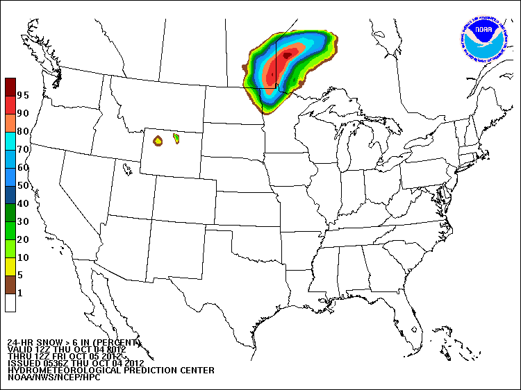
The snow event is not over yet, with the probability of snowfall of 6 inches or more being relatively high across portions of northwestern Minnesota and extreme northeastern North Dakota through tonight:


Meanwhile, the cold front associated with this early season snowfall is gathering strength and will take a dive Southward this weekend, bringing a significant cooldown to a large part of the nation to the East of the Rockies.

The image below shows the departure from normal temperature forecast valid at 1pm CDT on Sunday.  You can see a huge bullseye of temperatures that are forecast to be 20-30 degrees or more below normal across much of western and central Texas and the Oklahoma/Texas panhandle region:


Though to a lesser degree, temperatures will fall well below normal levels across a large chunk of the middle part of the country, within the green and light purple shadings on the same image (scale in degrees F on the right).

This abnormality will equate to temperatures only in the 40s and 50s during the middle of the day on Sunday across the Texas/Oklahoma panhandle region into much of West Texas, eastern New Mexico and western Oklahoma:


After a chilly start on Monday, temperatures will moderate quickly and will be back to near or even above normal levels by mid-week next week across much of the same region.

For more information from 'The Original Weather Blog', including shorter, more frequent posts during rapidly changing weather events, please be sure to follow Rob on facebook and twitter:
 

If you are in need of customized, site specific weather forecasts or storm warnings for your company or event, be sure visit Rob's professional webpage at WeatherGuidance.com.

Wednesday, October 3, 2012

Snow Flying Across Parts of North Dakota...


Above is an image from the NWS radar site at Bismarck, ND, which has the new "dual-polarization" technology on board (for more on that, see this post from earlier in the year).  

The light blue shading shows the radar's depiction of snow, but we get a little more detail than that thanks to the new dual pol technology.  As you can see on the scale to the left side of the image (blown-up below), that shade of blue corresponds with "DS", which stands for Dry Snow, meaning that the radar is detecting smaller, dry or powdery snowflakes.  The term "WS" (right above DS), stands for Wet Snow, which would indicate larger snowflakes with higher moisture content.

This should allow us to be more precise in estimating the intensity of wintry precipitation across the country this upcoming season.


Surface reports indicate that snow is beginning to accumulate across portions of western North Dakota.  So far, we've received reports of 2.0 inches at Billings and Slope, 3.0 inches 1 mile East of Dickinson and 3.5 inches to the East/Northeast of Grassy Butte.

A recent shot from KQCD's tower camera in Dickinson shows rooftops and even some parts of the ground are becoming covered in white:


Up to 4-6 inches of snow is forecast tonight in a band from west-central through central North Dakota, including the Dickinson and Jamestown areas, as well as across a large area between Bismarck and Minot.

For more information from 'The Original Weather Blog', including shorter, more frequent posts during rapidly changing weather events, please be sure to follow Rob on facebook and twitter:
 

If you are in need of customized, site specific weather forecasts or storm warnings for your company or event, be sure visit Rob's professional webpage at WeatherGuidance.com.