
The above image shows the amount of snow on the ground across North Dakota at 7am CDT this morning. The darker blue shadings represent 2-4 inches, with the pale blue/almost white areas 1-2 inches. Not huge amounts for this region by any stretch of the imagination, but it's pretty remarkable for this time of the year considering the still warm ground temperatures, etc.
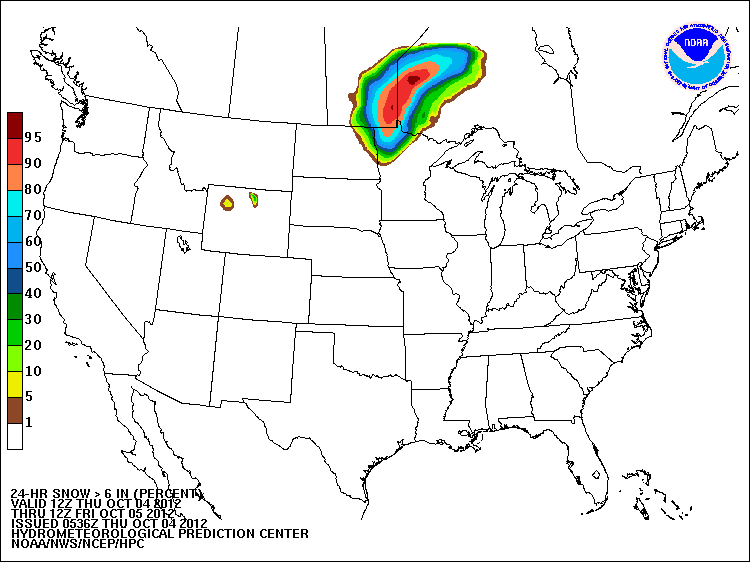
The snow event is not over yet, with the probability of snowfall of 6 inches or more being relatively high across portions of northwestern Minnesota and extreme northeastern North Dakota through tonight:
Meanwhile, the cold front associated with this early season snowfall is gathering strength and will take a dive Southward this weekend, bringing a significant cooldown to a large part of the nation to the East of the Rockies.
The image below shows the departure from normal temperature forecast valid at 1pm CDT on Sunday. You can see a huge bullseye of temperatures that are forecast to be 20-30 degrees or more below normal across much of western and central Texas and the Oklahoma/Texas panhandle region:

Though to a lesser degree, temperatures will fall well below normal levels across a large chunk of the middle part of the country, within the green and light purple shadings on the same image (scale in degrees F on the right).
This abnormality will equate to temperatures only in the 40s and 50s during the middle of the day on Sunday across the Texas/Oklahoma panhandle region into much of West Texas, eastern New Mexico and western Oklahoma:

After a chilly start on Monday, temperatures will moderate quickly and will be back to near or even above normal levels by mid-week next week across much of the same region.
For more information from 'The Original Weather Blog', including shorter, more frequent posts during rapidly changing weather events, please be sure to follow Rob on facebook and twitter:


If you are in need of customized, site specific weather forecasts or storm warnings for your company or event, be sure visit Rob's professional webpage at WeatherGuidance.com.
No comments:
Post a Comment