The satellite presentation of Sandy is much more impressive than this time yesterday, as you can see above. The circulation is much better defined, and there is convection (shower and thunderstorm activity) all around the center. As of the 8am EDT advisory, maximum sustained winds were estimated at 75 mph, and the minimum central pressure was 951 millibars (or 28.08 inches of mercury).
Sandy is moving toward the Northeast at 10 mph, and this general motion is forecast to continue today and early Monday, before taking a turn toward the North and then Northwest during the day Monday. I generally agree with the National Hurricane Center (NHC) forecast track shown below, which is a blend of the observational data as well as the GFS and European computer model solutions:
The same view of the GFS model valid at the same time shows the center inland over southern New Jersey:
As you can see, the main difference (from a practical perspective) between the two models is one of timing of landfall. This is somewhat irrelevant in the grand scheme of things, as the wind field is so huge in association with Sandy, which means that tropical storm and hurricane conditions will be felt well ahead of the arrival of the center, and for a significant period of time after the center has made landfall.
I'd like to also take a look at another forecast model, the high resolution NAM model, which is also U.S. based. Here is a still shot of that model valid again at 8pm EDT Monday, to be consistent with the above two images:
This model is also very consistent with the European and GFS models, and depicts a landfall of the center of Sandy along the southern Jersey coast. This model agrees with the GFS that landfall will be near 8pm on Monday, as shown above.
What I'd like you to pay attention to on that model is the low-level wind field. The scale to the right is in knots. You can take 1 knot and multiply it by 1.15 to reach the wind speed in miles per hour. The model is forecasting sustained winds of 80 knots, or 92 mph, across much of the NYC metro area, as well as Long Island and northern New Jersey. Values are closer to 100 mph over Long Island. This doesn't even factor in the gusts, which will be at least 20-25 mph higher in most cases.
In a post yesterday, I pointed out that glass breakage in high rise buildings will be a major concern across NYC and other areas tomorrow. I mentioned that for every 30 stories you can add roughly 20-25 mph of wind speed. If we have 90 mph winds at the surface as the above model indicates (and the European model does as well, by the way), we could estimate 110-115 mph winds at the 31st floor of a building, and 130-135 mph winds at the 61st floor of a building. Once again, we are not even factoring in the gusts here, so you get the idea of the potential magnitude of this situation - hence the major concern regarding widespread glass breakage across the affected region tomorrow evening and early Tuesday.
The image below shows the expected wind impacts across the region for Monday and Tuesday, and I don't believe that any changes are necessary from when I originally posted it, as the track is coming in just as expected:
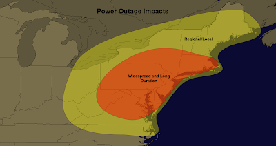
Such conditions will result in widespread power outages across much of the same region:
This will be a long duration high wind event, which will further compound the tree, power line and structural damage threat across the region. The models described above suggest that winds of 60 mph or higher will begin as early as midday Monday across much of the Delmarva region, much of New Jersey, Long Island and the NYC Metro area, and will continue until 1 or 2am on Tuesday morning.
Storm surge flooding is another major concern of mine. The latest surge model data based on the above tracks and intensity show widespread storm surge of 5-10 feet across the region, with locally higher levels of 10-15 feet possible. The presence of a full moon is making this situation even worse than it would already be. The first image below is a wide shot of Jersey, Long Island and the NYC Metro area valid at the peak water height on Monday evening:
...and this image is a zoom-in on the same as above, focused on the greater NYC area:
The water height scale in feet is shown on the bottom right corner of each image. As you can see in the 2nd image, a large inundation of water at the 10 plus foot level is forecast over much of Staten Island, with 5-10 foot (locally 12 feet) across much of lower and eastern Manhattan.
The way that Sandy is coming into the region will also mean that storm surge flooding will be of a longer than usual duration, with many areas remaining under water for significant periods of time as the storm moves West/Northwest across the area.
If you live in Hurricane Evacuation Zones A and B in the greater NYC area, I highly suggest that you make plans to leave the area no later than tomorrow morning - preferably today if at all possible. I realize that "officials" in the city government are still not recommending an evacuation, but as I have maintained since Friday, I believe this is a very foolish move that they will regret. Hopefully they see light today and take appropriate action before it is too late for folks to react.
Speaking of it being too late to react, I want to mention one more time for the record that I strongly disagree with the National Weather Service / National Hurricane Center's decision to not issue Tropical Storm and/or Hurricane advisories further North along the U.S. coast yesterday. I believe this foolish decision has lead to some people, quite possibly the leadership of the City of New York, to make poor decisions in preparing for Sandy. Sandy will hammer the region with Category 1 or Category 2 hurricane conditions with respect to winds and Category 3 conditions with respect to storm surge in many areas. I highly suggest that folks in Sandy's path continue to prepare accordingly.
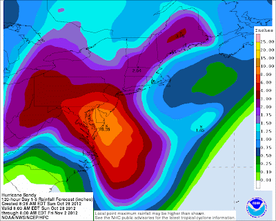
In addition to the storm surge flooding which will be a widespread threat, widespread rainfall amounts of 6 plus inches are forecast across the region, especially along and South of the track of the center of Sandy:
This will result in a widespread threat of flash flooding and river/stream flooding across much of the Delmarva peninsula region, as well as central and southern New Jersey.
Today is the last full day that you'll have to prepare for Sandy across the region. If you plan to stay put and ride out the storm, please make sure that you have secured extra supplies of batteries, bottled or gallon jugs of water, propane for cooking food on a gas grill, etc. I'd plan to have all portable electronic devices fully charged no later than 12 Noon on Monday, as the threat of power outages will begin on a widespread basis shortly thereafter. It still may also not be too late to obtain a portable charging device or power inverter for your car so that you can keep devices charged during the storm.
There are winter weather and high wind aspects of the system that will come into play further to the West as well. I will address those and other issues shortly in a separate post...
As you might imagine, we are seeing lots of new visitor traffic here on the blog with the approach of Sandy. Welcome visitors! Please don't bookmark any particular post for updates, as new posts will be made each time we have new information to pass along. Please check the homepage of the blog and refresh there for the latest posts...
If you would like to monitor the latest satellite and radar imagery associated with Sandy, please visit the Tropical Page at our sister site, WeatherGuidance.com. We will be adding additional imagery and information throughout the coming days.
For more information from 'The Original Weather Blog', including shorter, more frequent posts during rapidly changing weather events, please be sure to follow Rob on facebook and twitter:
If you are in need of customized, site specific weather forecasts or storm warnings for your company or event, be sure visit Rob's professional webpage at WeatherGuidance.com.


No comments:
Post a Comment