A powerful middle and upper level storm system will move out into the Plains on Saturday, causing a potentially widespread round of severe weather across portions of the central and southern Plains and into the Midwest.
The latest severe weather outlook for Saturday from the Storm Prediction Center (SPC) is shown below:

In general, severe thunderstorms are forecast anywhere within the brown and yellow shaded areas on the image, beginning in the West and spreading to the East with time. Severe weather is forecast to become the most widespread, and likely the most significant with respect to intensity, within the red shaded area on the same image.
By late afternoon or early evening, severe thunderstorm activity will be well underway from central and eastern Iowa to the Kansas City Metro area, back into eastern Kansas and central and/or eastern Oklahoma. Isolated to scattered severe storms will also extend Southward along the pre-frontal trough/dryline feature into western Texas.
At this time it appears that the most potent severe weather threat for Saturday afternoon and evening will extend from portions of central and eastern Oklahoma into eastern Kansas, western Missouri and much of Iowa. This includes the cities of Oklahoma City (early in the period), Tulsa, Joplin, Kansas City and Des Moines:

Within this region, storms will initially be scattered in nature at midday or early afternoon, with a threat for large hail and tornadoes, a few of which could be strong and/or have longer than normal track lengths. As the episode progresses, the activity will likely congeal into one or more solid lines, with a pronounced threat of potentially widespread damaging winds from late afternoon into the evening hours as the activity moves toward the East.
Further to the South and Southwest, isolated to scattered severe storms can be expected along a dryline in northwest and west-central Texas on Saturday afternoon. This activity will move Eastward into the DFW Metroplex by Saturday evening. Large hail, damaging winds and an isolated tornado or two are possible in this region.
Additional thunderstorm development is likely to take place into southwestern Texas and the Big Bend region on Saturday afternoon and evening. This activity likely congeal into one or more larger complexes of storms that will move East and Southeast toward the I-35 corridor in central and southcentral Texas by Saturday night and early Sunday morning. One or more of these complexes could impact the Austin-San Antonio area toward or just after dawn on Sunday morning. Locally heavy rainfall will be the primary threat by that time.
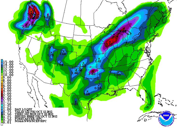
In addition to the severe weather threat, widespread rainfall amounts of 1-3 inches are forecast across much of the region in association with this storm system and surface front. Below is the latest rainfall forecast from the HPC valid 7am CDT today through 7am CDT Monday:
One of the higher resolution computer models is forecasting several swaths of 2-4 inch rains across Oklahoma, Kansas and Missouri, as well as west-central Texas. The image below is the cumulative rainfall forecast from that model, valid 7am CDT today through 7am CDT on Sunday:

If you live in the severe weather threat areas for Saturday, please pay particular attention to the weather. Listen to NOAA Weather Radio, local media or another trusted source for the latest information, watches and possible warnings.
Take the time in advance to make sure your severe weather safety kit is prepared and/or re-stocked, and be sure to identify your best sheltering options so that you can move there quickly if need be.
For more information from 'The Original Weather Blog', including shorter, more frequent posts during rapidly changing weather events, please be sure to follow Rob on facebook and twitter:
If you are in need of customized, site specific weather forecasts or storm warnings for your company or event, be sure visit Rob's professional webpage at WeatherGuidance.com.
2 comments:
Thanks for the update!
Omaha/Lincoln area are at the very edge of the slight risk...it should mainly be to the east/south-east of there, right?
Anthill,
Correct. It currently appears that the timing of things would be "off" for a significant severe threat there. Pre-dawn activity may produce marginally severe hail and heavy rain though.
Post a Comment