I've seen several bloggers/tweeters compare the forecast synoptic situation for tomorrow afternoon to that of May 8, 2003, which produced a significant tornado in Oklahoma (the F4 event in Moore, to be specific).
I'll post some images below and let you be the judge...
Observed 500mb chart for 00Z on 5-9-03
NAM 500mb Forecast valid 00Z 5-11-10
Observed 850mb chart for 00Z on 5-9-03
NAM 850mb Forecast valid 00Z 5-11-10
Observed Surface chart for 00Z on 5-9-03
NAM Surface Forecast valid 00Z 5-11-10
If the above NAM model forecasts verify, many of the wind fields will be as strong or stronger than the 2003 event. The images below compare the observed soundings & hodographs for Norman, OK from the May 8,2003 event to the forecast soundings & hodographs for tomorrow afternoon:
Observed OUN Sounding for 18z on 5-8-03
NAM Forecast Sounding for OUN valid 18Z 5-10-10
NAM Forecast Hodograph for OUN valid 18Z 5-10-10
Observed OUN Sounding for 00z on 5-9-03
NAM Forecast Sounding for OUN valid 00Z 5-11-10
NAM Forecast Hodograph for OUN valid 00Z 5-11-10
I think that some differences in the amount/depth of low level moisture and instability may be the most significant in comparing the 2003 event to what is forecast to unfold tomorrow. In my opinion, the keys here will be (1). the amount of low level moisture return (and depth of that return) over the next 24 hours, and (2). how much low-level heating will be able to take place in the warm sector tomorrow afternoon.
If I had to put a "target area" down myself, I would match it very closely to the SPC's current Day 2 Moderate risk area:
If the NAM model forecasts verify for tomorrow afternoon, I would place the most significant tornado risk, at least initially, in a narrower corridor from near Oklahoma City to near Wichita, spreading East/Northeast with time during the evening.
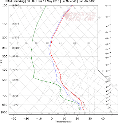
Just for the heck of it, here is the point sounding & hodograph forecast for Wichita, KS for tomorrow afternoon:
NAM Forecast Sounding for ICT valid 00Z 5-11-10
NAM Forecast Hodograph for ICT valid 00Z 5-11-10
Needless to say, it will be very interesting to see how this situation unfolds tomorrow. If you live in this area and are an "ordinary citizen", please keep abreast of the latest information and be prepared to take quick action if severe weather threatens your area. If you live in this area and are a storm chaser, get that gas tank filled-up, the camera loaded and get ready to roll! Best of luck and safety to all!


No comments:
Post a Comment