Showing posts with label Invest 95L 2011. Show all posts

Wednesday, October 19, 2011

Update on East Coast / Midwest Storm System

As expected, Invest 95 was absorbed by the frontal boundary near Florida early this morning. Shower and thunderstorm activity is breaking out all along the front and ahead of a developing upper level storm system from New England back into the mid-Atlantic coast, while heavy rains still linger across far Southern portions of Florida.


As upper-level energy increases across the frontal boundary today and tonight, low pressure will strengthen across the Ohio Valley and Delmarva region, with the GFS model depicting strong S-SW winds of 60-70 mph offshore from North Carolina to near Cape Cod by this evening (image valid 8pm EDT this evening shown below):

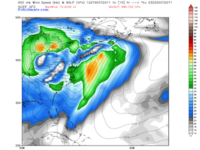

Further inland, strong winds of 30-40 mph with gusts to 50 mph can be expected by this evening from parts of the Carolinas on up into New England, as indicated on the same image (blue shaded and white shaded areas).

An even greater wind threat will be developing further West this evening, specifically across the Chicago area and much of Michigan, where sustained winds of 40-50 mph with gusts above 60 mph will be possible (image below is GFS forecast valid 10pm CDT this evening):
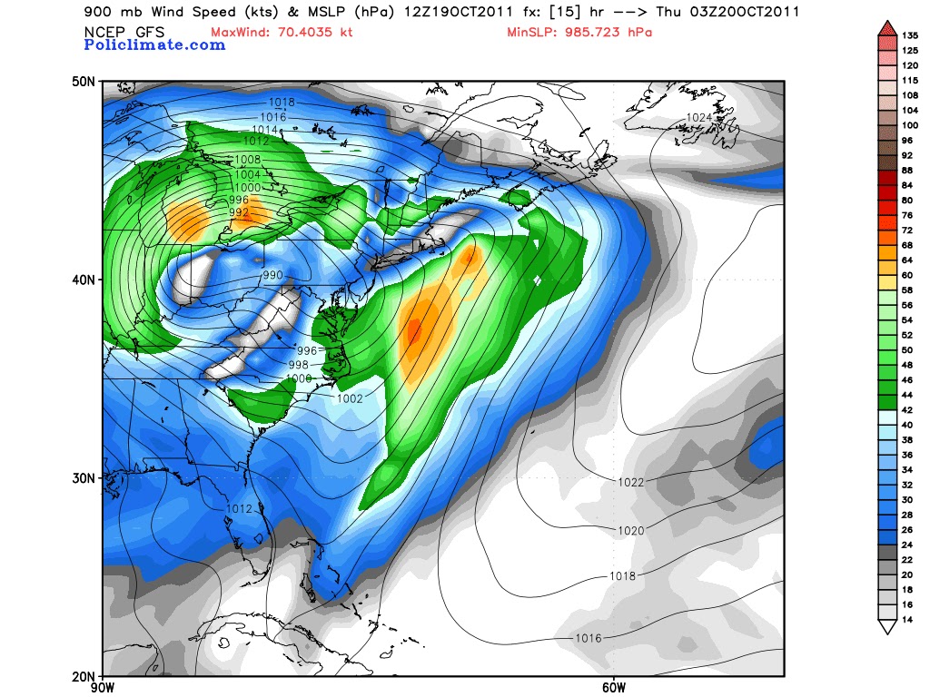

Note the stronger winds developing over Michigan, particularly the brighter orange shaded areas, which represent the models estimate of 60+ mph winds near the surface.

The strong winds will blow almost directly North to South along the entire length of Lake Michigan, which will push water up along and into the Southern shores of the lake, including the Chicago area and adjacent portions of Indiana.  This, along with high wave action (perhaps on the order of 20 feet or more), will produce a significant threat of lakeshore flooding by this evening and into tonight.
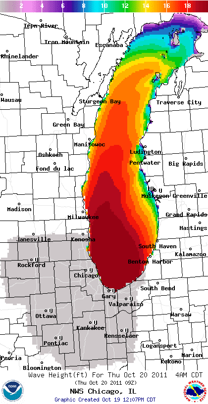

The image above from the NWS in Chicago's website indicates a forecast of widespread 18+ foot waves along the Illinois and Indiana shores of Lake Michigan by 4am CDT Thursday.  The winds are likely to crank up starting around 3 or 4 o'clock this afternoon and continue to increase into the evening and overnight hours.

***Update 4pm CDT:
The photo below was just posted on Tom Skilling's facebook page by Corey Wojtkiewicz, showing the waves starting to get rockin' along the lakeshore in Chicago:


Winds at both Midway and O'Hare airports are currently averaging 20-25 mph sustained, with gusts of 35-40 mph.  This is only the beginning, as winds will become even stronger later this evening and into tonight.

Watch for an update (via a new post thread) later this afternoon or early evening...


If you enjoy reading 'The Original Weather Blog', please be sure to "like" our facebook page!

Tuesday, October 18, 2011

Florida Continues to be Pounded by Invest 95L...


If you look closely within the yellow circled area on the above visible satellite image, you can see the swirl of clouds associated with the center of Invest 95.  You can see it even better on the zoomed-in image below:


Widespread rain and thunderstorm activity, some heavy, continues well off to the East and Northeast of the center, overspreading much of the Southern half of Florida at this time:


Precipitation will continue to increase across Florida throughout the remainder of today and into tonight, with widespread 2-4 inch totals likely, and localized amounts in excess of 6 inches possible, especially within the purple shaded areas on the image below:


Doppler radar at Key West is indicating sustained 40-50 mph winds just above the surface to the West of that location, spreading East/Northeastward.  Based on these observations, I would expect to see the wind increase out of the South to Southwest at 40-50 mph with gusts to 60 mph across westcentral and southwest Florida by mid to late afternoon.  This trend is supported by the latest GFS model forecast valid at 5pm EDT this afternoon, which depicts sustained winds of 50 mph in the green shaded areas on the image below:


These stronger surface winds will continue to overspread the remainder of the state by late afternoon and into this evening, as shown on the model forecast image valid at 8pm EDT this evening:


...and at 11pm EDT this evening, spreading off to the East:


In addition to the threat of heavy rains and strong winds, isolated tornadoes will also be possible this afternoon and evening, mainly across the southern half of the state.  I would not be surprised to see a Tornado Watch issued soon for this region.

Remember, a system doesn't have to have "a name" to cause problems, and hopefully folks in Florida have been taking this seriously as we've been talking about this for several days now.

If you enjoy reading 'The Original Weather Blog', please be sure to "like" our facebook page!

Monday, October 17, 2011

"Invest 95" - Or A Hybrid - To Pound Florida, Eastern Seaboard...


Moderate to heavy rain is widespread across far southern Florida this afternoon, as "Invest 95" spreads copious amounts of tropical moisture Eastward into the "Sunshine State."  Today is only a preview, as the main show is still to come Tuesday into Wednesday for Florida, and Wednesday into Friday for the remainder of the Eastern Seaboard...


The latest visible and infrared satellite images of Invest 95 are shown below:


I've noted the center of circulation associated with the system at the tip of the yellow arrow on the visible satellite image.  The yellow circle on the same image shows where moderate to heavy thunderstorm activity is currently concentrated.  As you can see, the heavier activity (which also corresponds with the strongest winds) is still well removed from the center, which is one of the reason's the system has not been named thus far by the National Hurricane Center.

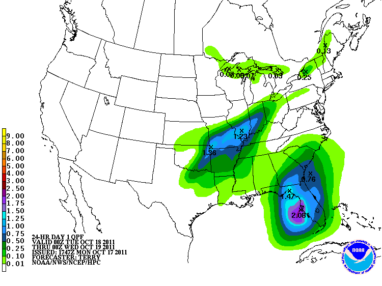
Regardless as to whether or not the system becomes named before striking Florida, its affects will be felt, both in the rain and the wind departments.  Below is the latest forecast for rainfall from the HPC for the period 8pm EDT today through 8pm EDT Tuesday:


Localized amounts of 4-6 inches are possible during the same period of time, especially near the darker blue and purple shaded areas.

Sustained winds are forecast to increase into the 30-40 mph range, with gusts up to 60 mph possible across a large portion of the Florida peninsula during the day on Tuesday.  The GFS computer model image valid 8pm EDT on Tuesday is shown below.  The stronger winds (gusting to 50-60 mph) are indicated by the white and light orange shaded areas near the center of the state:


Sustained winds of 30-40 mph with gusts up to 50 mph are likely within the remainder of the green shaded areas across Florida (on the same image) during the day Tuesday.

The system is then forecast to lift Northward at an accelerated pace and become "extratropical" by the Wednesday through Friday timeframe.  The winds will continue to crank up, with sustained levels of 80-85 mph indicated off of the North Carolina coast on the GFS computer model forecast valid 11am EDT on Wednesday (red and orange shaded areas on the image below):


By 8pm EDT on Wednesday, suistained winds of 90-95 mph are forecast by the model immediately offshore of the coast of Cape Cod:


During the same period of time, sustained winds of 30-40 mph with gusts up to 60 mph are likely to spread Northward along the coast from the Carolinas to New England on Wednesday, as well as a significant distance inland (as noted by the lighter blue and green shaded areas on the above forecast images).

Heavy rainfall will also become widespread during this time, with widespread amounts of 2-4 inches and local amounts of 6 inches plus along the seaboard from the Carolinas to southern New England:


So, regardless as to whether or not this system has a name during the next 24 hours, folks all along its path are in for a wet and windy time over the next 2-3 days.  At into the mix a strong cold front, and some folks across the eastern Ohio Valley may also see some wind driven snow flakes late Wednesday into early Thursday morning.


If you enjoy reading 'The Original Weather Blog', please be sure to "like" our facebook page!


Recon Mission Finds Strongest Winds Far from Center of Invest 95L...


An Air Force Hurricane Hunter aircraft is currently completing its mission into Invest 95, the disturbance we've been talking about for several days now, near the Yucatan Peninsula.

The center of the system is located just immediately offshore to the East of Progreso (see image above).  You can see a small swirl to the clouds in that location.  The aircraft found 40-50 mph surface winds, but they are displaced well to the Northeast and East of the center of the system (as noted in black on the image above).

The fact that the center has been over or very near land for the last 12 hours or so has likely prevented widespread development of stronger sustained winds near the center of the system.

Named storm or not, heavy rains continue across far southern Florida at midday, and will increase statewide during the next 12-24 hours as this system slowly approaches from the West.  Winds will also be on the increase across Florida by tomorrow, and this system is shaping up to become a rather potent storm (again, whether tropically named or not) across the Eastern Seaboard later this week.

I'll have an updated, detailed post on the latest outlook for this system from Florida to New England later this afternoon...


If you enjoy reading 'The Original Weather Blog', please be sure to "like" our facebook page!

Hurricane Hunter Aircraft to Investigate System Near Yucatan...

***Update 12:35 PM CDT: The Air Force Hurricane Hunter aircraft flight has begun. They are currently approaching the system from the Northwest, as shown on the image below:


I'll make a new post outside of this one once all of the data is in...

--------------------------------------Original Post Below:


As the sun rises over the Yucatan Peninsula, we can see the first visible satellite image of Tropical Invest 95-L. Thunderstorm activity continues to increase on the Eastern side of the systrem, near the western tip of Cuba.  Meanwhile, shower and thunderstorm activity are already spreading Eastward ahead of the system into southern Florida this morning...the first of many days of rain for the "sunshine state".


The National Hurricane Center is going to send a hurricane hunter aircraft into the system later this afternoon.  This should give us a much better idea as to its overall structure and tell us whether or not further development (of a tropical nature) is likely...


If you enjoy reading 'The Original Weather Blog', please be sure to "like" our facebook page!

Sunday, October 16, 2011

Wet, Windy Scenario Shaping Up for East Coast Thanks to System Near Yucatan...


Regardless of what exactly happens with the tropical system attempting to organize near the Yucatan Peninsula (latest visible satellite image shown above), the computer forecast models are increasingly hinting at a wet time to be had not only for Florida, but for the Northeast as well.  In addition, very windy conditions are likely along the east-central and northeast U.S. coastline as the system combines with a strong upper-level weather disturbance and surface cold front by mid-week.

The series of images below shows the GFS computer model's interpretation as to what will happen to the system beginning 8pm EDT Tuesday, October 18th, through 8pm EDT Wednesday, October 19th:


As you can see, we begin late Tuesday afternoon with a relatively weak (wind-wise) system traversing Florida (while dumping copious amounts of heavy rain).  By Tuesday night and early Wednesday, the system is forecast to strengthen as it becomes absorbed by a strong surface cold front and upper level trough, with surface winds forecast to increase into the 80+ mph range just offshore of the Carolina coastline by dawn on Wednesday:


Even if the system is initially classified as tropical when impacting Florida on Tuesday, by this time Wednesday it would likely have been re-classified as "extratropical" as it will have become absorbed by the larger surface through upper level storm system impacting the Eastern U.S.

The fierce storm is then forecast to spread 80+ mph winds just offshore of Cape Cod by 8pm EDT on Wednesday evening:


...before racing off into southeastern Canada by dawn on Thursday:


Note the strong Northwesterly winds (upwards of 50 mph) that the model is forecasting to come off of Lake Erie into northern Ohio and northwestern New York state on Thursday morning!  It may even be cold enough in this region for precipitation to fall as some wind-whipped snow flakes (although significant accumulation does not appear likely at this time) on Thursday morning...

Stay tuned for updates.  First order of business will be to determine whether or not this system will cause any problems for Florida, other than the heavy rain that we already know will take place late Monday through Wednesday...


If you enjoy reading 'The Original Weather Blog', please be sure to "like" our facebook page!

Tropical Disturbance Continues to Organize Near Yucatan...


Above is the latest visible satellite image of the tropical disturbance that we've been talking about near the Yucatan for the past several days.  The corresponding infrared satellite image is shown below:


The National Hurricane Center (NHC) has dubbed the system "Invest 95L", which means they are paying a bit more attention for signs of development.  This initiates close-up satellite surveillance, such as the images you see above, as well as hurricane hunter aircraft flights into the system for more detailed observations.  All of this data is fed into the computer models which should also produce a more reliable product there as well...

Thunderstorms are becoming more organized near the center of the disturbance this morning, and wind gusts to tropical storm force have been observed by ships passing through the Yucatan Channel (in the Northeast quadrant of the system).

The latest radar image from the Cancun, Mexico site shows less intense precipitation taking place on the Western side of the system at this time:


This corresponds well with the satellite imagery above, which suggests that the stronger thunderstorm activity is  currently taking place on the Eastern side of the system.

Speaking of the computer models, the GFS continues to show this system meeting with with a cold front and moving East/Northeast toward Florida by mid-week.  The latest image valid 8pm EDT on Tuesday, 10-18-11, is shown below:


This trend matches up rather well with the remainder of the model consensus, which is shown on the image below:


Regardless as to whether or not the system has tropical characteristics when it impacts Florida late Tuesday and Wednesday, widespread, heavy rainfall will be a major problem across the region, as alluded to in the outlook that I posted yesterday.  In the meantime, we'll need to keep a close eye on this system today and Monday in an effort to determine what other impacts may potentially be felt across Florida...


If you enjoy reading 'The Original Weather Blog', please be sure to "like" our facebook page!