Friday, March 2, 2012

Major Tornado and Severe Weather Outbreak Today OH/TN Valley and Deep South...

Conditions continue to indicate that a major outbreak of severe thunderstorms, including tornadoes, is likely across the Ohio and Tennessee Valley and parts of the Deep South this afternoon and tonight.

The latest severe weather outlook from the Storm Prediction Center (SPC) indicates that severe storms are likely within the yellow shaded areas on the image below:


The highest risk of severe storms, including potentially damaging tornadoes and very strong, damaging straight line winds, is within the red and lavender shaded areas on the same image.  This enhanced risk of severe storms and tornadoes includes the cities of Louisville, Evansville, Bowling Green, Nashville, Cincinnati, Indianapolis, Columbus, Charleston (WV), Chattanooga, Atlanta, Birmingham, Tuscaloosa, Huntsville and Tupelo.

As expected, thunderstorms are already underway across portions of the Midwest and Tennessee Valley this morning:


A Severe Thunderstorm Watch is in effect for the following areas (shaded in blue) until 11am CST:


This activity will continue to move and develop East/Northeastward along and ahead of a surface warm front through midday.  This is only "round 1" of the activity, and will be the least severe of the day, with large hail the primary threat during the morning hours.

By midday, new thunderstorm activity is expected to develop along and ahead of a cold front from central Illinois back into Arkansas, near the Western edge of the severe weather outlook area.  The activity forming along the warm front extending Eastward from Illinois into Indiana and western Ohio may also reorganize and/or intensify at that time.

By afternoon, widespread severe weather will be underway across the enhanced severe weather outlook area (red and lavender shaded areas on the original image), with large hail, strong, potentially long track tornadoes, and damaging straight line winds likely.


The highest risk of tornadoes, some of which are likely to be strong and/or long track, is within the red, lavender and black hatched areas on the image below:


The highest threat of damaging winds is within the lavender and black hatched areas on the following image:


This is a very dangerous and potentially life threatening situation for the indicated areas. 


Folks living across the above mentioned areas should be on a high state of awareness when it comes to the weather today and tonight.  Listen to local media or another trusted source for the latest weather information and possible warnings.

Take a few moments to review severe weather safety and preparedness tips, that way you'll be sure to have the right tools on hand and react quickly if threatening weather approaches your area.  This process should include taking the time to identify the best sheltering option (whether at home or work) and have a plan in place to get there quickly.


Folks further to the East within the severe weather outlook area should prepare for activity tonight.  In addition to reviewing the above, make sure that you have a way to receive weather warnings at night.


If you enjoy reading 'The Original Weather Blog', please be sure to "like" our facebook page!

Thursday, March 1, 2012

Make Sure that You Have a Way to Receive Severe Weather Warnings At Night


It feels like I've mentioned it a thousand times here on the blog, but this is the first time I've dedicated an entire post to the subject.  One of the most important things that you can do to protect your family during severe weather season is to make sure that you have a way to receive severe weather warnings when you are the most vulnerable - when you're asleep in your bed at night!

In this post I'll review 3 of the easiest ways for you to receive a severe weather warning at night.

The first way to receive a weather warning at night is not a new one:  a NOAA Weather Radio with a battery back-up and S.A.M.E. technology (the last part might be new to you, and I'll explain it shortly).


This is one of the easiest and most widely accepted ways that you can ensure that you'll receive a nighttime weather warning.  It may also be the least expensive, depending on your personal situation with cellphones, etc. (which we'll get to in a moment).

The above is a NOAA Weather Radio made by Midland, the leader in NOAA Weather Radio production in the U.S.  It features S.A.M.E. technology, which is very important.  S.A.M.E. (which stands for Specific Area Message Encoding) allows you to pre-program your weather radio to only sound the alarm in the event that a specific type of weather warning is issued for your area.  

Back in "the old days" the NOAA Weather Radio sounded its alarm (which was ear piercing) anytime a warning was issued within the entire listening area of the radio transmitter (which can be 10-12 counties - or more).  With S.A.M.E. technology, the alarm will only sound for the county or counties that you pre-program into the radio.  You can also choose a specific type of warning (i.e., severe thunderstorm, tornado, flash flood, etc.).  

S.A.M.E. technology is not really new, but it may be new to you.  I bought a NOAA Weather Radio at RadioShack when I was 10 years old.  S.A.M.E. wasn't around back then.  Midland built the radio so well that it lasted 25 years!  So, the technology was new to me when I had to replace the radio some years back.  You might be in the same situation.  If so, and if you find yourself turning off your NOAA Weather Radio because it always "goes off" for every county in your area, it might be time to invest $30-40 and purchase a new model with the programming technology built in!

Because of my great experiences in purchasing weather radios there for many years, I always recommend RadioShack if you're in the market for a new or replacement model.  Most of the stores will even help you program your new radio as well (if they won't do it, send me an e-mail and I'll help you myself).  Take a look at this post, the NOAA Weather Radio Buyer's Guide, for more details on this inexpensive, potentially life saving technology and how you can get it.


This next way to receive a severe weather warning at night might be new to you.  It was to me until about 30 days ago (and I consider myself a tech junkie - I just hadn't looked into the technology until recently because I tend to be up anyway when "bad" weather is going on).  In general, I'm talking about smartphone apps that will alert you to severe weather warnings issued for your area.  Specifically, I'm talking about the "iMapWeather Radio" application for the iPhone.

This app is $9.99 in the AppStore.  Kind of pricey as apps go, but the technology is very impressive - and it may save your life one day.

In a nutshell, the iMap Radio app does the same thing the NOAA Weather Radio with S.A.M.E. technology does, but it goes a step further...


While the NOAA Weather Radio and the iMap Radio application will both alert you to a pre-selected warning area and watch or warning type, the iMap Radio app goes a step further.  It uses GPS technology to lock-in your specific latitude and longitude location.  It will then literally warn you only if that specific location is included in the National Weather Service's warning polygon.  The NOAA Weather Radio warns you if any part of the entire county is warned on - not a specific geographic location within that county.


I tested both the NOAA Weather Radio and the iMap Radio app one night in January when we had severe storms here in the Austin area.  Sure enough, when a Severe Thunderstorm Warning polygon was issued for extreme Eastern parts of Hays county (which is the county in which I reside), the NOAA Weather Radio went off immediately.  The iMap Radio app, however, did not alert me, because my specific GPS location was not within the warning polygon (I live in the other part of the county that wasn't in the warning polygon area).


What exactly am I talking about with regard to polygons and all?  The above image shows the specific warning example that I was talking about.  The NWS warning polygon is outlined in red (as noted on the image).  My location in Hays county is at the tip of the yellow arrow (just to the West of the warning polygon).  Since any part of Hays County (as shown in white) was located in the warning polygon, the NOAA Weather Radio dutifully sounded the alert.  However, since my precise GPS location was just outside of the warning polygon, the iMap Radio app did not alert me.

I guess you could call the iMap app "NOAA Weather Radio with S.A.M.E. alert on steroids".  NOAA is under pressure to include GPS location technology in a new generation of weather radios, but I'll be completely honest when saying that there's no telling when that will happen.

The iMap Radio app is currently exclusive to iPhone technology.  They are reportedly developing an Android version of the application and I'll be sure to update this post when that technology becomes available.  In the meantime, Android users should search the Android Market for a similar technology (be sure to include GPS technology in your search where applicable).  I don't have an Android phone in my house, so I don't have a specific recommendation there at this time.  Any Android users with a similar technology that would like to post the source in comments are more than welcome to do so...


Finally, I'd like to point out a third method by which you can receive severe weather alerts at night:  text messaging services.  Many of these are free, sponsored by local TV and/or radio stations.  A quick search of the websites of major network stations in your area will likely reveal such a source.  

There are also several companies across the country that offer such a service free or for a small fee.  A quick google search of "free text weather alerts" will bring up a myriad of potential sources.

This technology is generally the most primitive of the 3 choices presented in this post.  There is often little room for customization, although most will allow you to specify at least the county that you'd like to be warned upon.  

With all of the above in mind, it's always a good idea to have a back-up.  If you choose either the smartphone app, or the free text alert programs, I strongly suggest also having a NOAA Weather Radio on hand as a back-up should one of the other sources fail to deliver.

Whatever the method, make sure that you and your family have a way to receive severe weather warnings at night.  It may prove to save your life - with little to no financial investment...

If you enjoy reading 'The Original Weather Blog', please be sure to "like" our facebook page!

In the interest of full and complete disclosure, I'd like to point out that none of the companies mentioned above have compensated me in any way to promote their products in this post.  Furthermore, none are paid advertisers on this blog (I don't have any paid advertiser's on this blog, for that matter).  I mention the products because I have tested them, use them, and believe in them.  As a result, I'm passing the information on to you.

Interesting Look at Rotation on Tuesday Night / Wednesday Morning's Storms...


The above image was provided by the NOAA Environmental Visualization Laboratory (EVL). It shows the output of a computer algorithm which attempts to identify where rotation in a storm (as indicated on area radars) may be strong enough to produce a tornado on the ground.  The algorithm uses a combination of wind and hail data to arrive at its conclusions.  This particular image shows the output of that data for the storms of Tuesday evening (February 28th) and early Wednesday morning (February 29th) of this week.

I have taken the same image and added the locations of the 4 cities that were hardest hit by tornadoes that night:  Branson, MO, Buffalo, MO, Harveyville, KS and Harrisburg, IL (click to enlarge):


A scale isn't provided, however the lightest shadings indicate the weakest rotational/tornado signature, and the darkest indicate the strongest signatures.

As you can see, the storm responsible for producing the Branson area tornado actually began rotating as it moved through Tulsa, and continued doing so all the way across the southern edge of Missouri and into extreme southern Illinois and extreme southwest Kentucky!

The storm responsible for the EF-4 tornado in Harrisburg, IL began showing strong rotation over southcentral Missouri (to the Northeast of the Branson storm).  

Both the Buffalo, MO and Harveyville, KS storms also showed relatively strong signs of rotation on radar well before they actually produced tornadoes on the ground (yet they too did not produce a tornado for the entirety of the rotational cycle).

Herein lies the challenge to the meteorological community:  lots of severe storms rotate, but not every rotating storm produces a tornado on the ground.  To further complicate matters, we have yet to establish any type of rule of thumb that says something like "a storm rotating at such and such velocity will generally produce a tornado 90 minutes after it starts rotating..."

This problem is by no means new, yet it is one that needs to be solved quickly in order to improve the current tornado warning system.  Until then, you are likely to continue to feel "overwarned" from time to time as meteorologists struggle with when to issue a tornado warning based off of radar with no ground truth data available to support the decision.

One step in the right direction is the ongoing upgrade of existing NWS radars to dual polarization technology.  You can see my post here for more details on what that technology promises to bring.

The Springfield, MO radar (which is the site nearest Branson) had the new upgrade in place prior to Tuesday's storms.  The output from that radar clearly showed a strong signature of tornado debris as the storm moved through Branson on Tuesday night:


Branson is located near the center of the image.  The dark blue and light green pixels indicate the presence of the debris associated with the tornado that was ongoing at the time the image was taken.

If you've been reading the blog for very long, you know that it's not unheard of for a debris ball to show up on radar (even before the upgrade).  What is unusual about the above image taken by the new technology on Tuesday night is that the Branson tornado was "only" rated EF-2 intensity.  In the past, with the old technology, a debris ball would not typically show up with a tornado that "weak" (most of the tornado debris ball signatures we saw last year with the old technology were EF-4 intensity or higher).

The ability to potentially detect the debris signatures of weaker and/or shorter lived tornadoes is a very promising advancement, indeed!

Several of the radars in the areas to be affected by severe weather tomorrow have recently been upgraded to the new technology as well.  I plan to monitor that new data tomorrow evening and will be sure to post any interesting findings...


If you enjoy reading 'The Original Weather Blog', please be sure to "like" our facebook page!

Widespread Severe Thunderstorm and Tornado Outbreak Likely Friday...


Above is the midday update of the Storm Prediction Center's severe weather outlook for tomorrow. Overall, there is very little change to the outlook as originally posted.  Please see the original post (below) for full details...

Original post from 7:56 am this morning:

I'm afraid that what we witnessed Tuesday night and Wednesday was only a preview of what's to come tomorrow. Another very strong middle and upper-level disturbance will combine with a strong area of low pressure and cold front at the surface to create a widespread tornado and severe thunderstorm outbreak.

The outbreak on Friday will likely affect an even larger geographic area than yesterday's... extending from the lower Mississippi and Tennessee Valley into the Ohio Valley.  The latest severe weather outlook for Friday from the Storm Prediction Center is shown below:


Severe thunderstorms are possible anywhere within the yellow shaded areas on the image.  The highest risk of severe weather, which includes a threat of significant wind damage as well as strong, potentially long track tornadoes, is located within the lavender and black hatched area.

The area with a significant risk of wind damage and/or tornadoes includes the cities of Tupelo, Tuscaloosa, Birmingham, Huntsville, Nashville, Evansville, Louisville, Bowling Green, Cincinnati, Indianapolis and Columbus.

Strong to severe storms may develop as early as tonight in the Ozarks of Missouri and Arkansas.  This activity will continue Eastward into the middle Mississippi Valley by dawn on Friday, and will reorganize and/or intensify during the day as it moves further East into the Tennessee Valley region.

In addition, widespread thunderstorm development will take place by midday or early afternoon on Friday along and ahead of a surface cold front, near the Western edge of the red shaded area on the image above.  This activity will continue to move and/or develop East/Northeastward across the primary severe weather outlook area during the afternoon and evening Friday.

Large hail, widespread damaging winds and strong, potentially long track tornadoes are all possible in these areas.

Folks living across the above mentioned areas should be on a high state of alertness when it comes to the weather on Friday.  Listen to local media or another trusted source for the latest weather information and possible warnings.

Take the time today to review severe weather safety and preparedness tips, that way you'll be sure to have the right tools on hand and react quickly if threatening weather approaches your area on Friday.  This process should include taking the time to identify the best sheltering option (whether at home or work) and have a plan in place to get there quickly.

I'll be monitoring this situation closely and will post any updates to the forecast as conditions warrant... but this is a pretty clear cut event, and I don't see any major changes coming forth...


If you enjoy reading 'The Original Weather Blog', please be sure to "like" our facebook page!

The Tornado Chronicles: Harveyville, KS Tornado of 2-28-12

A strong tornado struck the Harveyville, KS area just after 9pm CST on Tuesday evening, February 28, 2012. The official National Weather Service (NWS) Storm Survey has rated this tornado EF-2 intensity, which would suggest maximum winds of 111-135 mph.

The tornado caused significant damage to many structures including an apartment complex and the United Methodist Church, which was built in 1885.  Reportedly, the only thing left standing at the church was the concrete storm shelter, which I believe is beneath the steps that you can see in this photo below:


Based on the NWS survey, the tornado touched down 1 mile Southwest of Harveyville at 9:02 pm CST, and travelled along a path approximately 5 miles before ending about 4 miles Northeast of Harveyville.  The maximum width of the damage path was 150 yards:


So far, reports indicate that 12 people were injured as a result of this tornado. Unfortunately, one of those that were injured yesterday have since passed away, a 53 year old man.  It is reported that his home "collapsed" on top of him.  I do not know if it was a frame built home or a mobile home at this time.

According to one amazing story, a grandfather prevented his 8 year old grandson from being sucked out of the front window by catching him in mid-air in the living room.  He escaped with only minor injuries!

The following damage photos were taken by the NWS survey team:


Radar indicated a very strong rotational signature, as shown on this image as the storm approached Harveyville from the Southwest.  The circulation signature is circled in yellow: 


A Severe Thunderstorm Warning was in effect for Harveyville at the time that the tornado touched down.  The warning included the tag line that tornadoes sometimes form quickly in severe storms...as highlighted in the actual warning below:


I will reserve further comment on this aspect of the situation until after I've had an opportunity to thoroughly review all of the radar data, which I hope to get done today...

This post will be updated frequently over the coming days.  If you have an interest in this tornado, please bookmark the post and check back for updates over the next 24-48 hours as additional information becomes available...


If you enjoy reading 'The Original Weather Blog', please be sure to "like" our facebook page!

The Tornado Chronicles: Branson / Southwest Missouri Tornadoes of 2-29-12...

As expected, severe thunderstorms rolled through much of southwestern Missouri between 1 and 2 am CST on Wednesday morning, February 29, 2012.  Based on information obtained so far, there are 3 main areas with relatively widespread damage:  the first extends from near Buffalo to Lebanon (upper right corner of the image below - click to enlarge).  The second runs from Kimberling City to Branson (bottom center of the image), and the third extends from near Pittsburg, KS to the Stockton area (upper left corner of the image):


There have been reports of 3 deaths so far, from the Buffalo area (well to the North of Branson) and in Barry County (to the West of Branson).  An unknown number of injuries, mostly minor, have also been reported across the region.


Branson Tornado:
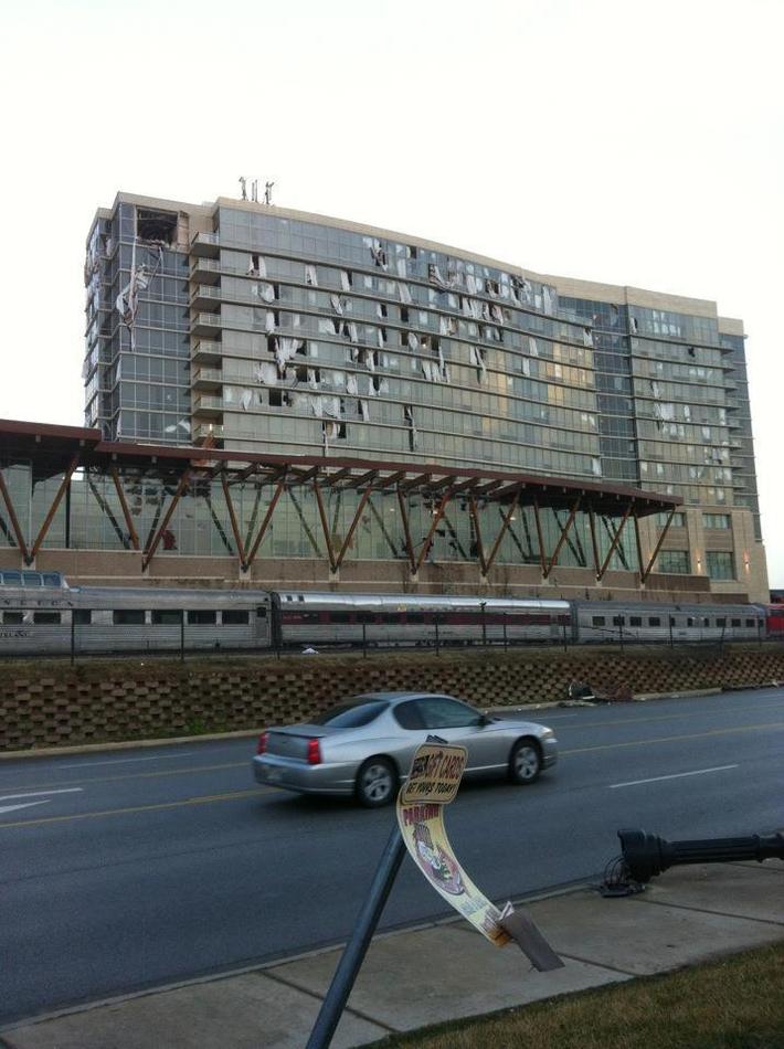
The following damage photos are flowing in from Branson:


The following video was taken by a local fire department as they drove through the damage area in Branson and surrounding areas.  The first 15 minutes of the video are a ground survey, with an areal view for about the last 5 minutes of the video:


The city of Branson recently released a statement asking that folks not just "show up" to help with recovery in the area.  They want to make it a coordinated effort, and will release further details on volunteer needs soon.  The American Red Cross and the Convoy of Hope are in downtown Branson distrubuting water, ice and food.  They are setting up at the First Presbyterian Church.

The preliminary storm survey from the National Weather Service (NWS) has rated the Branson area tornado EF-2 intensity.  According to the survey, the tornado touched down at approximately 1:13 a.m. CST near Joe Bald Road in Kimberling City.  It then tracked approximately 22 miles before lifting about 2 miles East of Kissee Mills at about 1:32 a.m. CST.  The maximum width of the damage path was 400 yards.  Estimated maximum wind speeds were 120-130 mph.

The image below shows the path of the Branson tornado based on the NWS survey data.  Branson is located near the center of the image:


The triangles at various points along the track indicate the EF-intensity of the tornado at that specific location.  You can see that EF-2 damage was observed not only in Branson, but also near the beginning point of the tornado near Kimberling City.

The NWS in Springfield has posted a loop of the radar imagery showing the line of storms as it moved across the region.  I will be posting more detailed radar imagery (including wind velocity data) soon.


Following is an aerial video posted on YouTube showing the damage across Branson and the surrounding area:


Buffalo Area Tornado:
The following photos have recently come in from the Buffalo area, which is about 25-30 miles North of Springfield.  The photos appear to be limited to the area in which the fatality took place in a mobile home:


The NWS survey of the Buffalo tornado indicates that it began approximately 5 miles South/Southeast of Halfway at 11:58 PM CST (on 2-28-12) and ended approximately 12:12 AM CST (2-29-12) approximately 2 miles East of Buffalo.  The maximum path width was 100 yards, and the tornado was rated EF-2 intensity.


The image below is the preliminary track map based on the NWS survey.  The format is the same as the Branson track map:


Damage from near Pittsburg to near Stockton:
It appears that the damage that took place from near Pittsburg, KS to near Stockton, MO was the result of straight line and/or downburst winds and not a tornado.


The photos below were taken from near Pittsburg and show tree limb damage, a few trees uprooted, and shingles being peeled off of a few homes:


Radar indicates that 80-100 mph winds likely took place across the region in association with this storm.  I will post some of the radar images soon.

Similar damage, and similar radar signatures, were observed along the remainder of the storm's path, through the Stockton, MO area.


Other Information:
This post will continue to evolve as new information is received.  Please check back frequently for updates over the coming days...


If you enjoy reading 'The Original Weather Blog', please be sure to "like" our facebook page!

The Tornado Chronicles: Harrisburg, IL Tornado of 2-29-12...

A violent tornado struck the city of Harrisburg, IL just before dawn this morning. Tragically, 6 people were killed and over 100 others were injured.

The local sheriff's office has reported that over 300 homes and 35 businesses were "destroyed" by the tornado.  

Take a look at this impressive photo of an unknown bank in Harrisburg:


If you look closely, you can see pock marks where bricks, 2x4's and other debris struck the building (from other buildings).  That's why I always say that flying debris is just as big of an enemy as the tornado itself.  This is another good reason to wear a crash helmet when you seek shelter, like our newly updated (for 2012) severe weather sheltering tips suggest.

A media report indicated that cancelled checks from the "Bank of Harrisburg" were found 70 miles to the East in Darmstadt, Indiana (which is on the North side of Evansville).  I'm not sure if the above bank is the one in question, but wouldn't be surprised if it were...


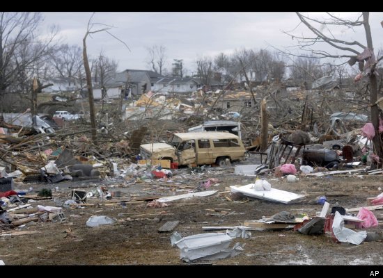
Following are additional photos that are coming in, all of which are striking as to the magnitude of the damage:


The National Weather Service (NWS) is still in the process of completing its survey, but based on preliminary data they have rated the tornado at EF-4 intensity.  They estimate that the tornado touched down at 4:56 am CST, had a maximum width of 250 yards and estimated peak winds of 180 mph.  So far, the track extends from 1 mile North of Carrier Mills to 2 miles East of Harrisburg (on Highway 13).  This is the point at which the survey team stopped yesterday.  They will resume their work today and we'll know the remainder of the extent of the track soon.  The image below shows an approximation of the track as it has been determined so far.  Harrisburg is the urban-looking area in the upper right quadrant of the image (click to enlarge):


It is very rare for an EF-4 tornado to strike in February (leap-year or not).  In fact, the last time an EF-4 (then termed F-4) tornado took place in Illinois in February was back on February 10, 1959 (in Madison County).  Before that, an F-4 was observed on February 25, 1956 (in St. Clair County).  The only other F-4 to occur in February in Illinois was way back on February 19, 1888 (in Jefferson County)!

Although the loss of 6 lives is tragic, I am amazed that the death toll wasn't higher based on the damage photos that we are seeing, not to mention the time of day in which this event took place.

This is an "evolving" post and is very fluid as new updates and information come in.  Please bookmark it and check back frequently for updates...


If you enjoy reading 'The Original Weather Blog', please be sure to "like" our facebook page!