As expected, severe thunderstorms rolled through much of southwestern Missouri between 1 and 2 am CST on Wednesday morning, February 29, 2012. Based on information obtained so far, there are 3 main areas with relatively widespread damage: the first extends from near Buffalo to Lebanon (upper right corner of the image below - click to enlarge). The second runs from Kimberling City to Branson (bottom center of the image), and the third extends from near Pittsburg, KS to the Stockton area (upper left corner of the image):

There have been reports of 3 deaths so far, from the Buffalo area (well to the North of Branson) and in Barry County (to the West of Branson). An unknown number of injuries, mostly minor, have also been reported across the region.
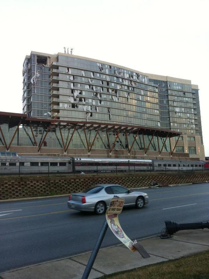
Branson Tornado:
The following damage photos are flowing in from Branson:


The following video was taken by a local fire department as they drove through the damage area in Branson and surrounding areas. The first 15 minutes of the video are a ground survey, with an areal view for about the last 5 minutes of the video:
The city of Branson recently released a statement asking that folks not just "show up" to help with recovery in the area. They want to make it a coordinated effort, and will release further details on volunteer needs soon. The American Red Cross and the Convoy of Hope are in downtown Branson distrubuting water, ice and food. They are setting up at the First Presbyterian Church.
The preliminary storm survey from the National Weather Service (NWS) has rated the Branson area tornado EF-2 intensity. According to the survey, the tornado touched down at approximately 1:13 a.m. CST near Joe Bald Road in Kimberling City. It then tracked approximately 22 miles before lifting about 2 miles East of Kissee Mills at about 1:32 a.m. CST. The maximum width of the damage path was 400 yards. Estimated maximum wind speeds were 120-130 mph.
The image below shows the path of the Branson tornado based on the NWS survey data. Branson is located near the center of the image:

The NWS in Springfield has posted a loop of the radar imagery showing the line of storms as it moved across the region. I will be posting more detailed radar imagery (including wind velocity data) soon.
Following is an aerial video posted on YouTube showing the damage across Branson and the surrounding area:
Buffalo Area Tornado:
The following photos have recently come in from the Buffalo area, which is about 25-30 miles North of Springfield. The photos appear to be limited to the area in which the fatality took place in a mobile home:


The NWS survey of the Buffalo tornado indicates that it began approximately 5 miles South/Southeast of Halfway at 11:58 PM CST (on 2-28-12) and ended approximately 12:12 AM CST (2-29-12) approximately 2 miles East of Buffalo. The maximum path width was 100 yards, and the tornado was rated EF-2 intensity.
The image below is the preliminary track map based on the NWS survey. The format is the same as the Branson track map:

Damage from near Pittsburg to near Stockton:
It appears that the damage that took place from near Pittsburg, KS to near Stockton, MO was the result of straight line and/or downburst winds and not a tornado.
The photos below were taken from near Pittsburg and show tree limb damage, a few trees uprooted, and shingles being peeled off of a few homes:


Other Information:
This post will continue to evolve as new information is received. Please check back frequently for updates over the coming days...
If you enjoy reading 'The Original Weather Blog', please be sure to "like" our facebook page!

There have been reports of 3 deaths so far, from the Buffalo area (well to the North of Branson) and in Barry County (to the West of Branson). An unknown number of injuries, mostly minor, have also been reported across the region.
Branson Tornado:
The following damage photos are flowing in from Branson:


The following video was taken by a local fire department as they drove through the damage area in Branson and surrounding areas. The first 15 minutes of the video are a ground survey, with an areal view for about the last 5 minutes of the video:
The preliminary storm survey from the National Weather Service (NWS) has rated the Branson area tornado EF-2 intensity. According to the survey, the tornado touched down at approximately 1:13 a.m. CST near Joe Bald Road in Kimberling City. It then tracked approximately 22 miles before lifting about 2 miles East of Kissee Mills at about 1:32 a.m. CST. The maximum width of the damage path was 400 yards. Estimated maximum wind speeds were 120-130 mph.
The image below shows the path of the Branson tornado based on the NWS survey data. Branson is located near the center of the image:

The triangles at various points along the track indicate the EF-intensity of the tornado at that specific location. You can see that EF-2 damage was observed not only in Branson, but also near the beginning point of the tornado near Kimberling City.
Following is an aerial video posted on YouTube showing the damage across Branson and the surrounding area:
Buffalo Area Tornado:
The following photos have recently come in from the Buffalo area, which is about 25-30 miles North of Springfield. The photos appear to be limited to the area in which the fatality took place in a mobile home:


The NWS survey of the Buffalo tornado indicates that it began approximately 5 miles South/Southeast of Halfway at 11:58 PM CST (on 2-28-12) and ended approximately 12:12 AM CST (2-29-12) approximately 2 miles East of Buffalo. The maximum path width was 100 yards, and the tornado was rated EF-2 intensity.
The image below is the preliminary track map based on the NWS survey. The format is the same as the Branson track map:

Damage from near Pittsburg to near Stockton:
It appears that the damage that took place from near Pittsburg, KS to near Stockton, MO was the result of straight line and/or downburst winds and not a tornado.
The photos below were taken from near Pittsburg and show tree limb damage, a few trees uprooted, and shingles being peeled off of a few homes:


Radar indicates that 80-100 mph winds likely took place across the region in association with this storm. I will post some of the radar images soon.
Similar damage, and similar radar signatures, were observed along the remainder of the storm's path, through the Stockton, MO area.
This post will continue to evolve as new information is received. Please check back frequently for updates over the coming days...
If you enjoy reading 'The Original Weather Blog', please be sure to "like" our facebook page!
1 comment:
Hi nice reading your bllog
Post a Comment