Below are a series of the latest forecast guidance from the HPC, first one being a surface weather map valid at 7pm CDT Monday:
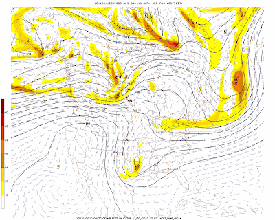
As you can see, a rather strong cold front is forecast to be advancing southward through the Plains. At the same time, a strong upper-level weather disturbance will be moving into the region as well, per the latest GFS model:
The above features will result in a good chance of showers & thunderstorms along and ahead of the front. The SPC is not currently forecasting a severe weather risk area for the region, however that may change in later forecasts, depending on how fast low-level moisture is able to return to the region:
By Tuesday morning at 7am CDT, the front is forecast to have moved offshore and into the Gulf of Mexico:
Cooler air will be spilling southward into the Plains, with a very fall-like feel instore through mid-week. You can see this trend continuing on the surface forecast map valid at 7am Wednesday:
Depending on the amount of low-level moisture that is able to return and over-run the cold front, a fairly widespread light rain even is likely across much of central and east Texas if the above scenario pans-out. This potential will be further enhanced by a strong upper-level weather disturbance that is forecast to be moving across the region at the same time. Here are the GFS model presentations of this feature at 7am Tuesday:
and 7am Wednesday:
Back to the surface map valid at 7am Wednesday, you might have noticed the tightly packed isobars emerging on to the lower right corner of the image (in the Carribean Sea). That is Hurricane Tomas, which is forecast to continue advancing into the Carribean as shown on the maps below, valid 7am CDT Thursday:
and 7am CDT Friday:
In the longer range, Tomas is likely to take a turn toward the North as it encounters the strong Southwest flow aloft from the advancing weather disturbance across the southcentral & southeast U.S. At this time it appears that these trends will likely turn the system out to sea before it could have any potential impact on the U.S. (including Florida).


No comments:
Post a Comment