
The center of Tropical Storm Isaac recently passed to the Southwest of Key West, FL and is heading for the warm waters of the southeast Gulf of Mexico. As of 4pm CDT, the center of Isaac was located about 40 miles Southwest of Key West, FL, and was moving toward the West/Northwest at 16 mph.
Maximum sustained winds are estimated at 60 mph, and the minimum central barometric pressure is 29.29 inches of mercury.

Now that Isaac has passed over and/or near the Florida Keys with minimal impacts, all attention turns to the next few days as the system moves across the eastern Gulf of Mexico toward an eventual landfall along the U.S. Gulf Coast.
Computer forecast model guidance continues to point to landfall of the center of Isaac somewhere along the coast of Louisiana or Mississippi late Tuesday or early Wednesday:

The latest forecast track from the National Hurricane Center (NHC) is near or slightly right of the model consensus, with Hurricane Warnings now in effect from southcentral Louisiana through the western Florida panhandle:

As I've been pointing out over the last few days, Isaac is now moving over some very warm, undisturbed waters over the eastern Gulf of Mexico. This should allow for rapid intensification of the system over the next 1-2 days. I continue to believe that Isaac will make landfall as a major hurricane and folks along the Gulf Coast from Louisiana to the western Florida panhandle should take this situation very seriously and prepare accordingly.
Its also important not to focus solely on where the center of the storm is expected to track. Isaac will produce tropical storm and/or hurricane conditions well away from the center, especially across the Eastern half of the system.
Very heavy, flooding rainfall can be expected along and especially to the East of the track of the center of Isaac. Based on the NHC forecast above, this would produce rainfall in excess of 15 inches from southeast Louisiana into extreme southern Mississippi, Alabama and the western Florida panhandle:
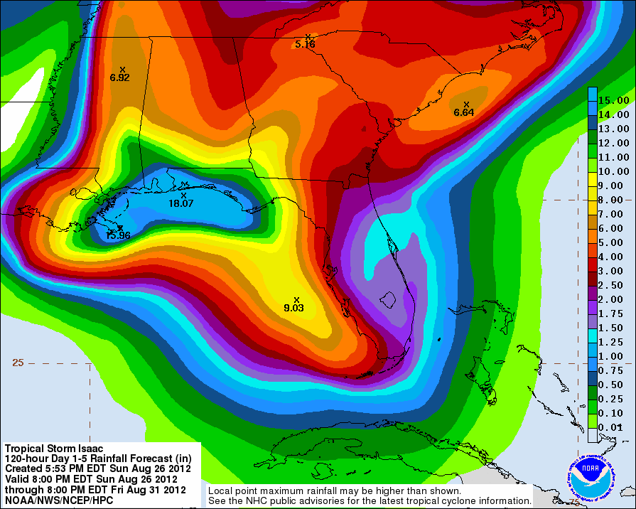
It is important to keep in mind that a track further to the West would shift the axis of heavier precipitation in that direction as well.
Depending on exactly when and exactly where the center of Isaac makes landfall (with respect to the time of high tide, etc.), the potential exists for a substantial storm surge with this system, particularly along the southeast Louisiana and southern Mississippi coasts based on the current forecast track.
As I mentioned above, folks in the projected path of Isaac and really all along the Gulf Coast from Louisiana to the western Florida panhandle should take this situation very seriously. You should not prepare for Isaac as it currently exists in Tropical Storm form, but prepare for a major hurricane - which is what Isaac will likely be at the time of landfall.
For the latest imagery and updates on Isaac, please refer to this dedicated webpage at our sister site, WeatherGuidance.com. Now that the system is threatening the U.S. in the near term, I'll be posting more frequent updates here on the blog. I will also post various shorter updates with additional images, etc., on both facebook and twitter. If you would like to receive those updates, please be sure to follow me there if you aren't already:


No comments:
Post a Comment