As promised in yesterday's blog, NOAA/NWS announced today their prediction on the upcoming Hurricane/Tropical Weather season. The link is here.
They too are forecasting an "active to extremely active" season. To be specific, they are calling for "a 70% probability" of 8-14 hurricanes, 3-7 of which "could be major".
Thursday, May 27, 2010
Wednesday, May 26, 2010
Thoughts on the Upcoming Hurricane Season

The internet and media are moving into "frenzy mode" with folks predicting what this year's hurricane season will bring. So why shouldn't I take a stab at it? My dog, Zoey, chased her tail 6 times last night instead of the 5 that she does in a normal evening, so that means we'll have 6 major hurricanes this season. No, just kidding, I have yet to find a correlation between her tail chasing activity and the severity of the Atlantic hurricane season, but I'm still looking into this possibility.
Seriously, last year was an "El Nino" year, which is historically unfavorable for a very active Atlantic hurricane season. Sure enough, it was a very, very slow season; in fact, it was the least active season since 1997. Before I go any further, it goes without saying that the season was indeed very significant for anyone affected by one of the 3 hurricanes that did form. As with all weather-related matters, everything is relative. With that said, overall, it was a quiet season.
Now, back to this year. The "official" hurricane season kicks-off on June 1. El Nino has ended, and waters in the tropical Atlantic are at near-record to record levels of warmth for late May. In fact, they are currently warmer than in the last extremely active year of 2005 (the year of Katrina).
Both Dr. William Gray and WSI, noted hurricane prediction "experts", are forecasting an "above average to highly above average" season. (In the interest of full disclosure, I must point out that WSI is affiliated with the B-Movie Channel with Occasional Weather - interpret that however you'd like). NOAA/NWS will issue their "official" outlook tomorrow, May 27th at 10am Eastern Time from Washington, DC.
So, what is my take on this? I do believe this will be a more active year, certainly more active than last year (admittedly, it wouldn't take much to do that). And as I always say, any hurricane that hits your hometown or the hometown of a loved one or friend is a really big deal, regardless of how the rest of the season goes.
If you live in a hurricane or tropical storm prone area, stay alert this season. You're much more likely to need your emergency kit than you were last year...
Tuesday, May 25, 2010
Supercells In Western Kansas ... Again!

The above is a shot of the Goodland, KS (KGLD) dopper radar, reflectivity mode (showing precipitation echoes), taken shortly after 8 o'clock this evening Central time. Note the strong "hook echo" signature on the eastern-most storm, to the North-Northeast of Scott City, KS. This is a classic indicator of a rotating, likely tornadic, thunderstorm.
Below is a shot of the same storm using the "storm relative velocity" mode (showing wind motion toward & away from the radar) taken at the same time. Remember that on any kind of velocity image, wind blowing toward the radar is depicted by the green and blue colors, while wind blowing away from the radar is shown by the red and yellow colors. In this case, the radar is located in the upper left hand corner of the image. With that in mind, note the broad circulation located near the reflectivity hook echo (depicted by the arrows inside the white circle). This is called the "mesocyclone", which is the first sign of organized rotation and tornado potential within a supercell thunderstorm.

If you look closely, right beneath the upper-most arrow within the mesocyclone, there is another (very small by comparison) spot where the red and green touch abruptly. That is the "tornado vortex signature" (TVS), or most likely where the ground-level rotation (tornado) is located. The TVS is highlighted by a smaller circle on the image below.

The Vortex 2 teams deployed on the storm located to the West (left) of this storm earlier in the evening, and observed from 3-5 tornadoes. It appears that that storm is either weakening or "cycling" (changing from one phase/intensity to another) while the storm to the North-Northeast of Scott City is strengthening and organizing at this time.
One more thing I'd like to point out. A Severe Thunderstorm Watch was issued for most of Western Kansas earlier this afternoon. The events that have unfolded this evening prove that just because a Tornado Watch is not issued doesn't mean that tornadoes can't (or won't) form. After all, the tornado doesn't know that it isn't forming inside a tornado watch area. Folks in tornado alley know to keep an eye to the sky regardless of what type of weather watch is in effect for the area. The local NWS offices in Goodland, Dodge City and Pueblo have done a good job warning on the tornadic potential of the affected storms, despite the earlier "forecast" of the Severe Thunderstorm Watch.
*** Updated at 9:55pm: The Storm North-Northeast of Scott City indeed went on to produce additional tornado reports, including a "large" tornado in Gove and Trego Counties:

*** Updated at 9:55pm: The Storm North-Northeast of Scott City indeed went on to produce additional tornado reports, including a "large" tornado in Gove and Trego Counties:

Sunday, May 23, 2010
Large, Wedge Tornado in SD Yesterday
I posted a storm relative velocity image (on Twitter) of a monster storm West of Aberdeen, SD yesterday evening. I even remarked that a "large" tornado had been reported with that storm. Well, large it was indeed! Take a look at this shot, taken by storm chaser Chris Collura near Bowdle, SD yesterday evening:


You can read more about Chris's chasing adventures on his website: http://sky-chaser.com/
Here is a video of the same tornado, shot by Randy Cooper of SevereStudios.
Here is a storm relative velocity image from the Aberdeen, SD (KABR) radar after the storm had moved just East of Bowdle. Note the strong rotation near the bottom center of the purple-colored tornado warning polygon. (Remember that green and blue colors depict motion toward the radar, while red and orange colors depict motion away from the radar; the radar is located at the right center portion of the screen).

Here is a reflectivity image of the same storm, taken about an hour earlier. Note the classic "hook echo" configuration:

Here is what the Aberdeen storm report log looks like (note that the log was sorted by tornado reports first, so it is not necessarily in chronological order):

Saturday, May 22, 2010
Thoughts on Chaser Convergence

The above image is a screenshot of the Rapid City, SD (UDX) radar taken just a few minutes ago. The little icons with cars and/or phones and the accompanying white text indicate the locations of storm chasers that have chosen to allow themselves to be tracked by GPS. (Keep in mind there are likely many other chasers in South Dakota right now who do not have GPS tracking technology available and are thus not being tracked, and/or have chosen not to be tracked).
I am truly amazed at how many chasers have made the long road trip to South Dakota on a "slight risk" day. This never would have happened a few years ago (heck, probably not even last year).
I haven't storm chased in many years (15+ to be exact), other than a couple of local excursions within a 15 mile radius of home. The last time I did go out on an organized/planned chase, we didn't have GPS tracking - heck, we couldn't even pull radar out in the field, we had to call back to someone at the office or in front of a computer that could lead us in the right direction, etc. Now days I guess you would say that we did things "the old fashioned way", by following our instincts and actually looking toward the sky rather than at a cellphone or computer monitor in the car.
Don't get me wrong. I'm a 110% techno junkie. If it's technical, and especially if it relates to the weather, I've either got it or am working on getting it. I love what technology has done to improve our understanding of weather, severe storms in particular, and how it has improved the public warning process. If we would have had today's technology available back when I was chasing on a regular basis, I'm sure I would have had it (or would have been working on getting it).
Getting back to the topic at hand; there has been much controversy over the past few days, at least in the weather freak/storm chasing community, about "storm chaser convergence". I'm not attempting to seek credit for coining that phrase, but I'll be glad to take a stab at its meaning: a term referring to the dramatic increase in the number of "storm chasers" flocking toward a particular storm, especially in well "advertised" severe weather situations. And with today literally being in the heart of the "information age", what severe weather events are not well advertised?
There are several YouTube video accounts of certain "chasers" passing folks at allegedly high speeds and in no passing zones, etc. in Oklahoma this past week. It is not my intent to dignify either the "offending" nor the "accusing" parties by posting any links here. You can Google for those videos, view them for yourself and make your own judgement.
My view is this: We live in a free country (at least at this particular moment). Anyone and everyone can choose to go out and look at a thunderstorm at anytime they wish - and that's absolutely the way it should be. With that said, I have always cautioned folks that have asked me about storm chasing that you either (1). need to know what you are doing, or (2). be with someone who knows what they are doing. This isn't an endeavor that should be embarked upon after drinking a few beers and seeing a good looking storm headed your way on the "B-Movie Channel with Occasional Weather".
It goes without saying that chasers should observe the "rules of the road" (not to mention the traffic laws) as much or perhaps even more so than the average citizen driving to and/from home, work or the store. As long as you can do that, and know what your limits are as far as not getting "too close" to the storm and not putting yourself or others in the wrong place at the wrong time, have at it. If you can't, or if you aren't sure that you can, I'd advise that you stay at home and watch the storms on the TV or the internet. (And hey - at least you can enjoy a few cold, malted beverages by doing it that way).
Update with a Handy IEM Link
I blogged a couple of days ago about all of the cool stuff on the Iowa Environmental Mesonet (IEM) site. I pointed out the fact that the site is so vast and the feature set so rich that I'm sure there are countless tools I have yet to discover on the site. Well, what do ya know...I've since discovered that they actually have an "update" page on their site that will introduce users to a different feature of the site each day. Here is the link:
http://mesonet.agron.iastate.edu/
Typical of the rest of the site, there's a lot of "stuff" that comes up when you click on the above link. If you look at the area toward the upper left portion of the page, you'll see the caption "Daily IEM Feature".
I've accessed the link to that page probably a hundred times over the past year and only just now came to realize there was a "daily feature" on there! Pretty handy. You may not use all of the stuff featured there, but you're bound to make at least 1,000 discoveries that you didn't know about before!
Friday, May 21, 2010
Tornado Damage found on May 19th Storm Near Tulsa
The NWS in Tulsa has been out the last 2 days surveying damage from the May 19th storms. They did find evidence of at least 2 tornado touchdowns in Creek County with the vigorously rotating storm that also skirted the southern part of Tulsa.
Here is what they found:
BRISTOW AREA TORNADO /CREEK COUNTY/
BEGAN...4 NE BRISTOW
ENDED...3.75 SW KELLYVILLE
PATH LENGTH...5 MILES
MAX. PATH WIDTH...ABOUT 600 YARDS
EF RATING...EF1 WITH PEAK WINDS ABOUT 105 MPH
DEPEW AREA TORNADO /CREEK COUNTY/
A BRIEF TOUCHDOWN OCCURRED ABOUT 2 ESE DEPEW AT ABOUT 709 PM. THIS TORNADO HAS BEEN RATED EF0.
Most of the radar imagery that I posted in my earlier blog about this storm was taken after these two touchdowns. I'll post some shots that better correlate to these events later this evening or tomorrow.
Thursday, May 20, 2010
Just What Exactly Are You On, Anyway?
I don't think they meant it to sound that way, but that's the question I've been getting from several folks lately. What they were really asking was for information on the programs that I use to post the radar and storm report images on my blog and in my Tweets.
For radar imagery, I use both GRLevel2 and GRLevel3. Full trial versions are available for immediate download at http://www.grlevelx.com/. After 21 days I believe you'll be asked to make a decision as to whether or not you wish to purchase the programs.
GRLevel2 displays reflectivity and velocity data in a higher resolution than GRLevel3. It also offers a feature where you can take a "slice" through a storm and display it in the vertical, in 3d-like fashion.


GRLevel3 shows not only reflectivity and velocity data (although in slightly lower resolution compared to GRLevel2), but also other "derived" data such as storm tops, vertically integrated liquid (VIL - a scientific and fancy way to pick out likely hail cores), 1 hour, 3 hour and storm total precipitation estimates, etc. It also displays all of the algorithms built into the NEXRAD system, such as mesocylone and tornado vortex signature plots, hail size estimates, storm tracks, etc.

I find that I use both programs about equally during a severe weather situation. They both will also display all active warnings, storm reports, spotter/chaser location data, etc. Both programs also use shapefiles and placefiles which allow you to add personal locations, roads, waterways, current conditions and any number of other snazzy features.
Once you have purchased GRLevel2 and/or 3, most of the data are then downloaded and ingested into the system for free. You can also subscribe to "premium" services like Allisonhouse (http://www.allisonhouse.com/) for specialized data such as lightning strikes, model data, etc. They also have a subscription level where you can go back and pull archived radar data even days or weeks after an event has ended. I subscribe to Allisonhouse mainly for the lightning data and the archive features. It also allows you to change the source where the NEXRAD data is coming from, which seems to be a bit more reliable than the "free" source, particularly during very active weather situations.
As far as the geographic storm report maps go, I've been using the Iowa Environmental Mesonet (IEM) located at www.mesonet.agron.iastate.edu/lsr/. They have numerous features on this website, storm report mapping just being one of them. Once you go to the storm report link, you select the NWS Office for which you'd like to plot reports, the date and time range and hit "load" and both a text and graphical representation will display shortly thereafter.

I find the IEM Site to be an extremely valuable tool in severe weather situations, both "live" and in an archived/historical setting. The features on this site are seemingly endless - I'm sure there are things on there I haven't discovered yet either...
For radar imagery, I use both GRLevel2 and GRLevel3. Full trial versions are available for immediate download at http://www.grlevelx.com/. After 21 days I believe you'll be asked to make a decision as to whether or not you wish to purchase the programs.
GRLevel2 displays reflectivity and velocity data in a higher resolution than GRLevel3. It also offers a feature where you can take a "slice" through a storm and display it in the vertical, in 3d-like fashion.

GRLevel2 Reflectivity Image

GRLevel2 Cross-Section "3D" Image

GRLevel2 Storm Relative Velocity Image
GRLevel3 shows not only reflectivity and velocity data (although in slightly lower resolution compared to GRLevel2), but also other "derived" data such as storm tops, vertically integrated liquid (VIL - a scientific and fancy way to pick out likely hail cores), 1 hour, 3 hour and storm total precipitation estimates, etc. It also displays all of the algorithms built into the NEXRAD system, such as mesocylone and tornado vortex signature plots, hail size estimates, storm tracks, etc.

GRLevel3 Split Screen Display
Reflectivity on the left, VIL on the right.
Lightning strikes, mesocyclone & hail overlays also shown.
I find that I use both programs about equally during a severe weather situation. They both will also display all active warnings, storm reports, spotter/chaser location data, etc. Both programs also use shapefiles and placefiles which allow you to add personal locations, roads, waterways, current conditions and any number of other snazzy features.
Once you have purchased GRLevel2 and/or 3, most of the data are then downloaded and ingested into the system for free. You can also subscribe to "premium" services like Allisonhouse (http://www.allisonhouse.com/) for specialized data such as lightning strikes, model data, etc. They also have a subscription level where you can go back and pull archived radar data even days or weeks after an event has ended. I subscribe to Allisonhouse mainly for the lightning data and the archive features. It also allows you to change the source where the NEXRAD data is coming from, which seems to be a bit more reliable than the "free" source, particularly during very active weather situations.
As far as the geographic storm report maps go, I've been using the Iowa Environmental Mesonet (IEM) located at www.mesonet.agron.iastate.edu/lsr/. They have numerous features on this website, storm report mapping just being one of them. Once you go to the storm report link, you select the NWS Office for which you'd like to plot reports, the date and time range and hit "load" and both a text and graphical representation will display shortly thereafter.

I find the IEM Site to be an extremely valuable tool in severe weather situations, both "live" and in an archived/historical setting. The features on this site are seemingly endless - I'm sure there are things on there I haven't discovered yet either...
Wednesday, May 19, 2010
South Tulsa Dodged A Bullet This Evening...
This......

And this...

Don't really equate to this....

Do they? Well, apparently so. So far this evening, it appears that South Tulsa and adjacent communities dodged a major bullet. A strong supercell developed over Creek county early in the evening and tracked Northeast, then making the classic severe "right turn" more toward the East toward South Tulsa with time. Circulation signatures were persistent and strong, with the strongest SW of Kellyville as shown here:

But with all of this radar "drama", not one ground report of a tornado was received. Not even a wind damage report. Not even a large hail report! Could a tornado have touched-down and gone unnoticed, wrapped in a shroud of rain and unreported large hail? Sure, absolutely. But with storms passing through a heavily populated area and with massive "chaser convergence" taking place throughout, I am stunned at the lack of reports thus far.
I anxiously await the morning...when perhaps the light of day may shed light on some otherwise unreported events. But for now, I have to chalk this storm up as "storm - 1; meteorologists - 0" on predictability.
Why do storms rotate strongly but never produce a ground-level circulation? In this case, we should be thankful that is what happened - and believe me, I am. I never like to see tornadoes strike populated areas. In the middle of a wheat field in western Oklahoma or Kansas is just fine with me. But why this particular storm didn't produce a "significant tornado", regardless of location, is another reason that we as meteorologists must continue to gather as much data as possible (like the Vortex 2 team is currently doing) in order to increase our understanding and make better forecasts and warnings in the future.
Tulsa, count your blessings tonight - but don't let your guard down. The meteorologists didn't "cry wolf"; this storm was a monster - it just decided not to wreak havoc on your community, and thank goodness for that!
Big Severe This Afternoon/Evening In Oklahoma

As advertised, it appears that another severe weather outbreak is about to unfold, centered across Oklahoma. Additional activity could develop southward into north Texas. This activity will move East this evening into portions of Arkansas & north Louisiana overnight.
If you live in these areas stay alert! Very large hail and strong, long-track tornadoes are possible!
I'll try to post some radar images and updates this evening. You can also follow me on Twitter (my ID is svrwxtweets), where it's sometimes easier to post a quick update and/or radar screenshot.
Tuesday, May 18, 2010
Big Supercell In TX Panhandle This Evening - Just a Preview????
A "classic" tornadic supercell ravaged the northern Texas panhandle this evening, producing several tornado reports and widespread, large hail reports.


KAMA (Amarillo, TX) Reflectivity Image at 6:13 pm CDT

KAMA (Amarillo, TX) Storm Relative Velocity Image at 6:13 pm CDT

KAMA (Amarillo, TX) Split Screen Image at 6:27 pm CDT
Reflectivity on the left; VIL (hail indicator) on the right
Lightning strike, circulation and storm report data overlays

Storm Reports through 10pm CDT
The VORTEX 2 team captured a huge amount of data on this storm this evening which will no doubt further that important research effort.
The real question is....was this evening just a preview of a much bigger severe weather day to come tomorrow? Time will tell, of course, but all indications from model data and pattern recognition suggest that tomorrow will be another significant severe weather day, with the primary threat area shifting East from today's location.
If you live in the threat area(s) outlined below, stay alert for rapidly changing weather on Wednesday! This could be as significant an outbreak as the one last Monday, 5-10-10. Of course, it will be a very significant outbreak for anyone that takes a direct hit from a tornado producing storm - no matter what the rest of the country thinks about it!

Sunday, May 16, 2010
Major Hailstorm Hitting OKC Metro
Many of the same areas hard-hit by last week's tornadoes are currently being pounded by a massive hailstorm. Hail from golfball to softball size has been reported across the OKC metro area during the last hour. Storm is moving Southeast....


Hail & damage photos from Twitter:
http://tweetphoto.com/22737306
http://yfrog.com/0e2awaj
http://twitpic.com/1ofp4m/full
http://twitpic.com/1ofodd
http://twitpic.com/1ofp50
http://twitpic.com/1ofu8h
http://yfrog.com/0e2awaj
http://twitpic.com/1ofruz
http://twitpic.com/1ofrbn/full
Tulsa Metro Tornado & Wind Damage of May 13, 2010 - Part I
I was born and spent the first 12 or so years of my life in Tulsa, so I naturally have a fondness for the city. I haven't been back in awhile (seems like family and friends always come to us rather than the other way around), and I'm sure there are parts of town I wouldn't even recognize since the last time I was there. Unfortunately, there may be a few spots in town that some current residents don't even recognize after last Thursday morning's storms.
From a local warning standpoint, the time of day of this event couldn't have been worse. Most folks were in bed asleep and had little knowledge of what was about to happen.
The storms rolled through (and I mean rolled through) between 4:45 and 5:05 a.m. The line, with embedded rotating comma heads, literally crossed the entire city from west to East during that short period of time!
Below is an image depicting storm reports received by the NWS in Tulsa for this event. Text details of the more significant reports are also shown:

At first glance of the radar (see reflectivity image below), a bow echo/wind damage event was about to take place as the line approached the Tulsa area from the West at nearly 60 mph, and gaining:

As the event unfolded, however, several rotating "comma heads" began to develop within the line, which resulted in a couple of short to moderate track tornadoes, as well as other isolated (though equally significant) touchdowns:

The above track estimates are based on a combination of the NWS Tulsa preliminary ground survey information and doppler radar circulation signatures (see images later on in this post). The time estimates along the tracks are based on radar signatures, as ground report times often lag the actual event times (for obvious reasons).
For purposes of brevity throughout the remainder of this post, I'll refer to the southern track as the "Kiefer" tornado and the northern track as the "Sapulpa" tornado (please note that the "Sapulpa" tornado actually began about 3 miles Northeast of that city).
The shorter, Kiefer, tornado track began between 4:41 and 4:46 a.m. The first ground truth report came from just East of Glenpool (estimated by radar to have occurred about 4:48 am) where "large tree limbs" were reported down, along with "large trees snapped at their bases". Below are the reflectivity and storm-relative velocity images taken at 4:46 a.m. (0946Z) from the Inola (INX) radar:


The circulation then continued to intensify as it moved NE across southern Tulsa county. Below are the reflectivity and storm relative velocity images from 4:50 and 4:54 a.m.:


According to the NWS Tulsa preliminary ground survey, the ground-based circulation lifted near 111th Street and Garnett Road. According to the proximity of the corresponding radar signature, this probably occurred at around 4:55 a.m. Damage was estimated at EF0-EF1 (winds of 65-110 mph) along the broken path of this circulation.
Radar continued to track a low-level circulation on to the Northeast, passing to the southwest of Broken Arrow at around 4:58 a.m. as seen on the images below:


At this time it appears that no more ground-truth tornadoes were generated by this particular circulation after this time. However, you can see by the last several sequences of images that numerous "comma heads" were evolving and cycling through within the leading bow echo signature throughout the entire line of storms. You can even see hints of smaller, weaker circulations on some of the velocity images at times (though none were as well developed nor as pronounced as those being pointed out specifically).
Immediately to the Southeast of the track of the circulation we've been examining, a brief but possibly significant tornado touchdown was reported shortly after 5am. The report was 1 mile Northeast of Oneta along highway 51. The NWS Tulsa preliminary survey has estimated damage at EF2 intensity (winds of 111-135 mph) by a "250-300 yard wide" tornado.
Below are the 5:03 a.m. Inola (INX) reflectivity and storm relative velocity images corresponding to this circulation. The white circle denotes a pronounced "comma head" signature on the radar. The location of the damage report is highlighted by the arrow and pink text box. I would estimate these images were taken about 2 minutes before the damage took place:


Below are the radar images of the same storm taken at about 5:07 am, or roughly 2-3 minutes after the damage was reported:


Once this comma head cycled through, no additional reports of damage were received from this particular part of the storm. It is very interesting to me (and fortunate for Tulsa, in hindsight) that this particular circulation produced such a wide and strong damage path, though extremely brief, while the circulations that passed directly through South Tulsa were much weaker, less wide and at the same time equally short lived!
In Part II we'll examine the tornado track that initiated near Sapulpa...
Saturday, May 15, 2010
Awesome Radar Data from Tulsa Area Storms of May 13th
This is what you call a teaser....


I've spent some time this afternoon looking at the radar imagery from the Tulsa area wind/tornado event of the early morning hours of the 13th. All I can say is pretty neat stuff. The grill is calling me now, so I won't be able to post anything in detail this evening. Look for an update tomorrow....
I'll post a couple of images below just to wet your appetite. Take a look and see what you can see. I'll share my thoughts, along with some additional images and ground-truth storm report mapping, tomorrow....

0958Z (4:58 a.m. CDT) Storm Relative Velocity Image from the Tulsa (INX) Radar
5-13-10

0958Z (4:58 a.m. CDT) Base Reflectivity Image from the Tulsa (INX) Radar
5-13-10
Storms Organizing Out West Again
Thunderstorms are beginning to develop and organize in West-Central Texas again....with their eyes on the I-35 corridor later this evening/tonight. The cell below near Mason is showing rotation, although it is entering the doppler radar "no mans land" between the San Angelo and San Antonio radar sites. At this distance, the rotation that is seen by the radar is at about 9,000 feet (obviously well above ground level). None-the-less, a rotating wall cloud has been reported by spotters in the last half hour.


Additional development is also likely to take place later this evening further to the West along an old outflow boundary/cool front through Southwest Texas. All of this activity will then likely merge into another complex and roll East/Southeast across parts of southcentral Texas later tonight...

The SPC recently issued the following discussion on the setup as well: http://www.spc.noaa.gov/products/md/md0576.html
Friday, May 14, 2010
What a Week in "Tornado Alley"
The title says it all....wowzer! Mother Nature didn't disappoint this week!
My "real job" has kept me too busy to post this week - but that doesn't mean that I didn't notice what was going on! I've been archiving radar and other data and imagery throughout the week and plan to make some posts this weekend.
Meanwhile, Texans should keep abreast of the weather tonight through Sunday, as several rounds of severe weather and/or flooding are likely to impact large portions of the state. Stay aware and stay safe!
Sunday, May 9, 2010
Potential for Significant Severe Weather Outbreak on Monday - Update 1
Surface moisture is beginning to make a move Northward in earnest. This trend should increase overnight and early Monday.


2133Z (4:33pm CDT) surface map depicting rough boundary of 60s-70s
dewpoints advancing Northward through Texas

SPC 3-Hour Dewpoint Change ending 21Z today (4pm CDT).
Meanwhile, thunderstorms continue to develop across NW Texas into parts of western Oklahoma on the nose of the incoming moisture and in an area of increasing lift:

2152Z (4:52pm CDT) Radar Image from OKC
It remains to be seen what, if any, effect this or other overnight activity could potentially have on tomorrow's severe weather outbreak...stay tuned!
(See my earlier post below for a more detailed discussion of tomorrow's potential for severe weather in OK and KS).
Potential for Significant Severe Weather Outbreak on Monday
I hate to potentially mess things up by jumping on board the "hype" bandwagon that I'm seeing on the internet and some of the media, but I must agree that tomorrow sure looks to be a potentially big severe weather day in the classic "tornado alley" region of OK/KS.
I've seen several bloggers/tweeters compare the forecast synoptic situation for tomorrow afternoon to that of May 8, 2003, which produced a significant tornado in Oklahoma (the F4 event in Moore, to be specific).
I'll post some images below and let you be the judge...


Needless to say, it will be very interesting to see how this situation unfolds tomorrow. If you live in this area and are an "ordinary citizen", please keep abreast of the latest information and be prepared to take quick action if severe weather threatens your area. If you live in this area and are a storm chaser, get that gas tank filled-up, the camera loaded and get ready to roll! Best of luck and safety to all!
I've seen several bloggers/tweeters compare the forecast synoptic situation for tomorrow afternoon to that of May 8, 2003, which produced a significant tornado in Oklahoma (the F4 event in Moore, to be specific).
I'll post some images below and let you be the judge...

Observed 500mb chart for 00Z on 5-9-03

NAM 500mb Forecast valid 00Z 5-11-10

Observed 850mb chart for 00Z on 5-9-03

NAM 850mb Forecast valid 00Z 5-11-10

Observed Surface chart for 00Z on 5-9-03

NAM Surface Forecast valid 00Z 5-11-10
If the above NAM model forecasts verify, many of the wind fields will be as strong or stronger than the 2003 event. The images below compare the observed soundings & hodographs for Norman, OK from the May 8,2003 event to the forecast soundings & hodographs for tomorrow afternoon:

Observed OUN Sounding for 18z on 5-8-03

NAM Forecast Sounding for OUN valid 18Z 5-10-10

NAM Forecast Hodograph for OUN valid 18Z 5-10-10

Observed OUN Sounding for 00z on 5-9-03

NAM Forecast Sounding for OUN valid 00Z 5-11-10

NAM Forecast Hodograph for OUN valid 00Z 5-11-10
I think that some differences in the amount/depth of low level moisture and instability may be the most significant in comparing the 2003 event to what is forecast to unfold tomorrow. In my opinion, the keys here will be (1). the amount of low level moisture return (and depth of that return) over the next 24 hours, and (2). how much low-level heating will be able to take place in the warm sector tomorrow afternoon.
If I had to put a "target area" down myself, I would match it very closely to the SPC's current Day 2 Moderate risk area:

If the NAM model forecasts verify for tomorrow afternoon, I would place the most significant tornado risk, at least initially, in a narrower corridor from near Oklahoma City to near Wichita, spreading East/Northeast with time during the evening.
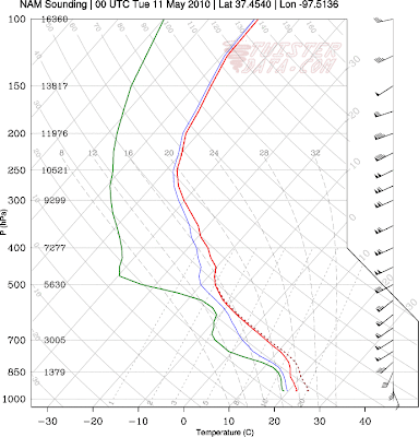
Just for the heck of it, here is the point sounding & hodograph forecast for Wichita, KS for tomorrow afternoon:

NAM Forecast Sounding for ICT valid 00Z 5-11-10

NAM Forecast Hodograph for ICT valid 00Z 5-11-10
Needless to say, it will be very interesting to see how this situation unfolds tomorrow. If you live in this area and are an "ordinary citizen", please keep abreast of the latest information and be prepared to take quick action if severe weather threatens your area. If you live in this area and are a storm chaser, get that gas tank filled-up, the camera loaded and get ready to roll! Best of luck and safety to all!
Subscribe to:
Posts (Atom)