Showing posts with label Severe Weather Outlooks. Show all posts

Thursday, June 16, 2011

Severe Weather Update for This Afternoon & Evening


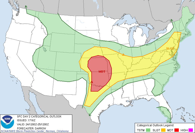
Severe thunderstorms are possible across a broad area from the central & northern Plains into portions of the intermountain region, as well as another area from the Ohio Valley into the Carolinas this afternoon & evening (as indicated by the yellow shaded areas on the image above).

Large hail and damaging winds will be the greatest severe weather threats today, however isolated tornadoes also cannot be ruled out, particularly when storms initially form and are more isolated and well organized.

Two clusters of thunderstorms continue to move Southeast this morning, having originally formed from overnight thunderstorm activity to the Northwest.  One is currently located over Kansas and the other is located over northwest Arkansas.  The Arkansas cluster is diminishing rather rapidly at this time, but the cluster over eastern Kansas is holding some organization.  It is possible that additional re-development / re-organization of thunderstorm activity will take place along and ahead of these clusters later this afternoon.  If this were to occur, it would most likely take place over western / southern Missouri, southeast Kansas and adjacent portions of northeast Oklahoma or northwest Arkansas.  Other re-development may also take place over central or southeast Arkansas along any outflow boundaries left behind by that cluster of storms.

It will become more clear by midday or early afternoon what, if any, boundaries are left behind by this activity, and what may focus additional thunderstorm development along or ahead of them this afternoon.  We'll post an additional update as that becomes more certain.

Otherwise, thunderstorms are expected to re-form by mid to late afternoon across portions of the High Plains (from Nebraska and South Dakota, 
Southward into Western portions of Kansas and Oklahoma) and move Eastward.  This activity is likely to congeal into one or more thunderstorm complexes later this evening and tonight, continuing to the East or Southeast (much like what took place during the pre-dawn hours of this morning).

Other development is expected to take place this afternoon & evening across the risk area in the Eastern U.S., with large hail & damaging winds being the primary threats.


Tuesday, June 14, 2011

Severe Weather Outlook for Today


Severe thunderstorms are possible, mainly late this afternoon into this evening and tonight, within the yellow shaded areas on the image above.  Large hail and damaging winds will be the primary threats.  A few tornadoes also cannot be ruled out, especially as activity initially develops this evening.  An enhanced risk of large hail will exist within the red shaded and black hatched areas on the image below:


An upper-level weather disturbance will move East into the central Plains and Midwest this afternoon & evening.  At the surface, the atmosphere will become very unstable, with a strong capping inversion in place which will initially inhibit thunderstorm development until late afternoon & early evening.  Once thunderstorms develop, they will quickly become severe.

The most likely area for initial development late this afternoon and early this evening will be within the red shaded and black hatched region on the image above.  As thunderstorms initially form within this region, they are likely to be supercells, with large hail, damaging winds and a few tornadoes possible.  As the activity moves and/or develops to the Southeast during the late evening and overnight hours, damaging winds will become the primary threat as the activity is expected to congeal into a large complex of thunderstorms.

At this time it is unclear how far to the Southwest thunderstorms will be able to develop this evening.  The cap will be very strong across southeast Kansas and northeast Oklahoma.  Any thunderstorm that is able to form in this area would likely be isolated but quickly become severe, with very large hail and damaging winds the primary threats.  

If you live in any of the above mentioned areas, please remain alert this afternoon & evening and be prepared to seek shelter if threatening weather approaches your area.

If you live across southern Illinois, southeast Missouri and adjacent portions of Kentucky, Tennessee and into adjacent portions of the Mississippi Valley, please be aware that severe thunderstorms may move into your region after dark tonight.  It would be a good idea to have a programmable NOAA Weather Radio or some other means of receiving nighttime warnings should severe weather threaten your area.

Thursday, June 9, 2011

Severe Weather Outlook for Today


A broad region of the country is included in the severe weather outlook for today, from the central Plains and Midwest, into the Ohio Valley and Northeast, within the yellow shaded area on the image above.

Within that broad area, the highest risk of severe weather will be located within the red shaded areas on the image below.  Very large hail is possible with thunderstorms that occur within the black hatched area:


Most of the threat will occur during the afternoon & evening hours, although some strong to locally severe thunderstorms are already occurring this morning in portions of the Midwest and Ohio Valley.  A Severe Thunderstorm Watch is currently in effect through late morning for the following areas:


Large hail & damaging winds will be the greatest threats with severe thunderstorms today, however isolated tornadoes are also possible with any thunderstorm that is able to become well organized.

I'll be travelling today and won't have many opportunities to make updated posts, so please be sure to monitor local weather sources and/or check the SPC site for later updates throughout the day....

Wednesday, June 1, 2011

Severe Weather Outlook for Today


The above is the latest severe weather outlook for today from the SPC.   Severe thunderstorms are forecast within the areas outlined in yellow.   Along the Northeastern corridor, large hail and strong winds are the greatest threats, although an isolated tornado also cannot be ruled out.

In the Plains, severe thunderstorms are forecast to develop late this afternoon into this evening along a dryline from southwest Nebraska, Southward near the Colorado/Kansas border.  Large hail, damaging winds and a few tornadoes will be possible with this activity.  We'll be heading to this area, with a preliminary target in the Colby, KS to McCook, NE area.  Stay tuned!

It is possible that some strong storms will form later this morning from the Texas/Oklahoma panhandles into northwestern Oklahoma.  Marginally severe hail will be possible with any storm that forms in this region.

Monday, May 30, 2011

Severe Weather Threat for Memorial Day


The above image shows today's severe weather outlook from the SPC in Norman.  Severe thunderstorms are possible anywhere within the yellow shaded areas on the image above.  An enhanced risk of severe storms, including tornadoes, large hail & damaging winds, is forecast within the red shaded area. 

Strong to locally severe thunderstorms are already underway early this morning from eastern North Dakota into portions of southern Minnesota.  This activity is not the "main show", which will come later this afternoon & evening.

If you live in these areas, please pay attention to the weather this afternoon & evening, especially if you have outdoor plans this Memorial Day.

Friday, May 27, 2011

Severe Weather Outlook for Today


Severe thunderstorms are possible this afternoon & evening anywhere within the yellow shaded areas on the image above. 

A surface dryline will become better defined today from Kansas into Oklahoma, along or just West of I-35 by late afternoon.  The atmosphere in this region, while becoming increasingly unstable, will also be very strongly capped.  This means that thunderstorm development late this afternoon & early this evening will be isolated.

Any thunderstorm that does manage to form would likely be severe, with very large hail and damaging winds the greatest threat.  An isolated tornado also cannot be ruled out, but this is not the primary threat today.

Thunderstorms may form on a more widespread basis across this region tonight, mainly along and either side of the Kansas/Oklahoma border into adjacent corners of southwest Missouri and northwest Arkansas.  This development will occur near a warm front lifting North across the region, as moist, unstable air continues to flow Northward after dark.  Large hail would be the primary threat with this activity tonight.

In the Northeast, scattered clusters or small lines of severe thunderstorms are forecast to develop this afternoon as a frontal boundary and upper-level weather disturbance continue to impact the area.  Large hail, damaging winds and isolated tornadoes will be possible with this activity.  Severe weather is not expected to be as widespread in this region as it was yesterday.

Thursday, May 26, 2011

Severe Weather Threatens Again Today - Not as Widespread/Intense


Severe thunderstorms are possible anywhere within the yellow shaded areas on the image above, mainly this afternoon & evening.  The greatest chance of severe weather, including large hail, damaging winds and a few tornadoes, is within the red & black hatched area on the image below:


A band of strong thunderstorms (leftover from overnight severe weather further to the West) is currently moving across middle Tennessee into northwestern Alabama.  Gusty winds and some spotty hail are the primary hazards with this activity as it continues moving Eastward this morning.  Widespread severe weather is not expected with this activity this morning.

Additional activity will redevelop near the Western border of the severe weather risk area this afternoon and progress Eastward this evening.  Large hail, damaging winds and isolated tornadoes are possible with the activity from mid-afternoon into this evening.

Please pay close attention to the weather this afternoon & evening if you live in these areas.

Wednesday, May 25, 2011

Tornado & Severe Weather Threat Continues Eastward Today...


The threat of severe thunderstorms, including tornadoes, continues to spread Eastward today, into the Midwest, Ohio, Mississippi and Tennessee Valley Regions.  The highest threat of severe thunderstorms, including the possibility of strong tornadoes, is within the pink and red shaded areas on the image above.


Very large hail (i.e., tennis ball size or larger) and strong tornadoes are possible within the pink, red and black hatched areas on the image above.  This threat includes the cities of St. Louis, Little Rock, Memphis, Evansville, Indianapolis and Lincoln.

Severe thunderstorms that began in Kansas and Oklahoma yesterday evening continue to progress Eastward this morning.  Tornado Watches are currently in effect for the following areas:


The threat of severe weather will not end across the watch areas once the current activity passes.  Thunderstorms are expected to redevelop in much of the same area (near the western border of the red outlined area on the 1st image) by early to mid afternoon, and progress Eastward into the evening.

In addition, the activity currently moving Eastward could reintensify over the Ohio Valley and portions of the Tennessee Valley later this afternoon.

Tornadoes, very large hail and damaging thunderstorm winds will all be possible with the activity this afternoon & evening.

If you live anywhere within the severe weather outlook areas, and particularly in the areas within the red and black hatching on the 2nd image, please pay very close attention to the weather today (particularly this afternoon & evening).


Tuesday, May 24, 2011

Severe Weather Update for This Afternoon - Kansas/Oklahoma/Texas


A major outbreak of tornadoes and severe thunderstorms continues to appear likely for this afternoon & evening.  The highest risk of tornadoes, some of which are likely to be strong and with long tracks, will be across the pink and red shaded areas on the image above.  In addition, very large hail and damaging winds can be expected with severe storms that form across this region.

At midday, a strong upper level storm system was spinning over the central and southern Rockies (red circled area on water vapor satellite image below):


It is accompanied by a very strong band of winds in the middle and upper levels of the atmosphere (as shown by the red arrow around the base of the system in the above image).

This system, and the strong band of jet stream winds, is forecast to lift out East/Northeast into the Plains this afternoon and evening.  As this occurs, thunderstorms will explode along a surface dryline near the western border of the highest risk areas, most likely between 2 and 3pm.

Based on current surface, computer model and satellite data, the series of images below shows how this situation is likely to unfold from mid-afternoon through mid-evening (click to enlarge):


The above is based on current trends, and could obviously change.  I will say that all available data has been very consistent over the last few hours in that the above estimates will be pretty close.  Also, the data has become even stronger at suggesting that one or more significant tornadoes (i.e., very damaging with a long track) are likely across this region this afternoon & evening.

Please note that the above hour by hour, regional outlook only applies to the region with the higest risk for strong, long track tornadoes.  There will be additional activity both to the North and South of these areas as well.

Due to the potential magnitude of the situation today, I would look for the SPC to issue Tornado Watches well in advance (perhaps an hour or more) of actual thunderstorm development in the affected areas.  The good news if you live in the Eastern half of the outlook area is that you will have plenty of time to track storms as they move and develop to the West, so we will be able to refine/adjust the forecast and give plenty of advance warning.

If you live anywhere within the pink or red outlined areas in the image at the top of the post, please take this situation very seriously - your life may literally depend on it!  Remain on a high state of alert this afternoon (starting 2pm in the Western portions of that region) and evening.   

There still appears to be the potential for a significant tornado threat after dark further to the East across portions of western Missouri and western Arkansas.  If you live in this region and do not have a weather radio or some other means of obtaining a warning at night, please go out this afternoon and buy one.  They cost between $20 and $40 and are available at most major chains such as Radio Shack, Wal-Mart, Target, etc.  DO NOT depend on an outdoor warning siren to alert you at night (or any other time of day).  These sirens were designed for OUTDOOR warning, not indoors or in vehicles as you may not always be able to hear them in those settings.

Major Tornado Outbreak Likely This Afternoon and Evening


As we first reported in a post yesterday, a major outbreak of tornadoes and severe thunderstorms is likely this afternoon & evening across portions of the central & southern Plains.

The highest risk of severe storms, including the potential for several long track, strong & damaging tornadoes, is located within the pink and red shaded regions on the image above.  This includes the cities of Wichita, Hutchinson, Pratt, Kansas City, Emporia, Columbia, Springfield, Joplin, Tulsa, Oklahoma City, Ponca City, Enid, Muskogee, Stillwater, Fayetteville, Ft. Smith, Rogers, and the Dallas /  Ft. Worth area. 

Significant tornado activity is possible anywhere within the pink, red and black hatched region on the image below:


A very strong upper-level storm system is rotating out over the central & southern Rockies this morning.  This system will lift out to the Northeast over the Western part of the highest risk area by mid-afternoon, resulting in explosive thunderstorm development along a dryline from central Kansas into western and central Oklahoma.  

Once developed, thunderstorms will initially move Northeast or East/Northeast, then turn more Eastward as they mature and produce tornadoes.  At least a few of the tornadoes are likely to be long track, strong and potentially very damaging.  In addition, very large hail (potentially baseball size or larger) and damaging thunderstorm winds will be possible with this activity.

The activity is expected to move and/or develop Eastward into adjacent portions of southeast Kansas, eastern Oklahoma, southwest Missouri and western Arkansas during the evening hours.  The significant tornado and very large hail threat will continue as the activity progresses into this region.  This unfortunately means that there is the potential for a very dangerous tornado threat after dark over the aforementioned areas of Missouri and Arkansas, as the storms continue Eastward.

This is a potentially very dangerous, life threatening situation for the highest risk areas described above.  Please remain on a high state of alert and be prepared to seek shelter immediately if threatening weather approaches your area this afternoon or evening.

Further Southward along the dryline in Texas, isolated to scattered severe storms are also expected to develop by late afternoon and into this evening.  Tornadoes, very large hail and damaging winds will also be possible in this area.  This activity is expected to move Northeast or East/Northeast initially, and will likely turn more Eastward as storms mature.  A strong tornado is also possible in this region, particularly over northwest Texas this evening.

Elsewhere, severe thunderstorms, including at least isolated tornadoes, are possible anywhere within the yellow shaded region on the 1st image.

Monday, May 23, 2011

Major Tornado Outbreak Likely Tuesday


Conditions appear favorable for a major outbreak of tornadoes and severe thunderstorms across Kansas and Oklahoma, as well as perhaps extreme northwest Texas, on Tuesday afternoon & evening.  The area at greatest risk is within the red shaded region on the map above.  This would include the cities of Great Bend, Salina, Wichita, Topeka, Kansas City, Chanute, Joplin, Fayetteville, Tulsa, Oklahoma City and Wichita Falls.

Tornadoes (some of which are likely to be long track and/or very damaging), very large hail and damaging winds can be expected across this region.

The strongest activity would likely develop near the western edge of the red area on the image above by 2-3pm Tuesday afternoon, with activity moving and/or developing East or Northeastward with time throughout the remainder of the afternoon and into the evening hours.

This is a potentially very dangerous weather situation.  If you live in the central or southern Plains, particularly in or near the red outlined areas on the image above, please pay very close attention to the weather on Tuesday.

Updated Severe Weather Outlook for Today


Above is the latest severe weather outlook for this afternoon & evening from the SPC.  They have upgraded portions of Oklahoma, southeast Kansas, southwest and southcentral Missouri and northwest Arkansas to a "Moderate" risk of severe weather (as shown by the red shaded area).  This means that areal coverage of severe thunderstorm activity is likely to be more widespread in these areas.  A similar risk upgrade was made to portions of the Ohio Valley.

Tornadoes will be possible with severe storms this afternoon, especially within the brown and yellow shaded areas on the image below:


Very large hail will also be another risk.  The greatest threat of very large (i.e., baseball size or larger) hail will be within the pink and black hatched area on the image below:


A cluster of strong to severe storms has already formed this morning along the Kansas/Oklahoma border and is now moving across southcentral Missouri, northwest Arkansas and extreme northeast Oklahoma.  This activity will continue to progress East/Southeast into adjacent portions of Missouri and Arkansas this afternoon, with damaging winds and large hail the greatest threats.

By mid to late afternoon, thunderstorms are expected to develop in Western portions of the Moderate risk area from southern Kansas into western Oklahoma.  This activity will move and/or develop Eastward into adjacent areas of southcentral & southeast Kansas and central and eastern Oklahoma by late afternoon and into this evening.  Very large hail, damaging winds and tornadoes will all be possible with this activity.

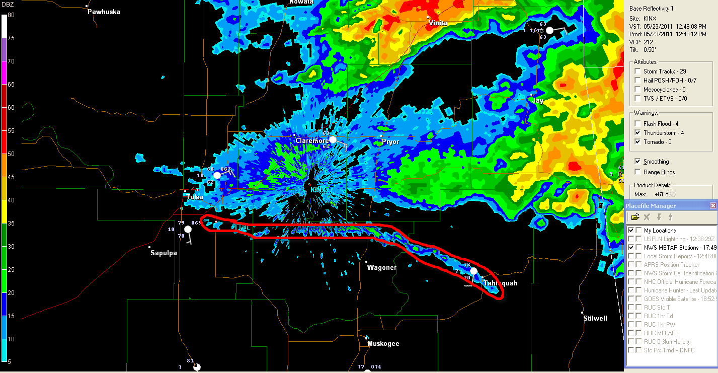
An outflow boundary is currently flowing southwestward from the thunderstorm complex along the Arkansas/Missouri/Oklahoma border areas, and is moving toward the Tulsa area (thin blue line circled in red on the radar image below):


Updated radar image showing outflow boundary as of 12:55 PM CDT:


As of 12:50 PM CDT, the Western end of the boundary has become nearly stationary over south Tulsa, while the Eastern end continues to move slowly Southward.

This boundary is likely to become a focus for new thunderstorm development this afternoon across northeast or east-central Oklahoma and west-central or northwest Arkansas and will have to be closely monitored.  Any cooler, more stable air that flows into northeast Oklahoma or northwest Arkansas behind this boundary could also influence the severity (i.e., decrease the severity) of any storms that may move in from the West later this afternoon.  We'll have to monitor for both of these possibilities this afternoon.

Meanwhile, in north Texas, thunderstorms are developing along the nose of a surge of instability just off the surface level, near the Dallas/Ft. Worth area currently.  A Severe Thunderstorm Watch was just issued for this area, valid until 5pm CDT:


Large hail will be the main threat in this area this afternoon.  The storms will also move very slowly, which could result in a flash flooding threat over time.

Severe Weather Outlook for Today, Monday, May 23, 2011


Above is the latest Severe Weather Outlook for today from the SPC.  In general, severe thunderstorms are possible anywhere within the yellow shaded area.

Within that large region, an enhanced risk of severe weather, including large hail and possible tornadoes, is forecast within the red shaded area on the image below.  This enhanced risk peaks within an area with the black hatch marks (over much of Oklahoma and the adjacent extremes of Kansas, Missouri, Arkansas and North Texas):


Severe thunderstorms are already getting underway this morning along the Kansas/Oklahoma border and a part of northeast Oklahoma.  A Severe Thunderstorm Watch has been issued for this region until 1pm CDT:


Damaging winds and large hail will be the primary threat in this region this morning, with a more pronounced threat of severe weather and possible tornadoes by late afternoon & into this evening.

Residents all across the severe weather risk area should pay attention to the weather today, and particularly if you live in the red or red & black hatched regions on the 1st two images.

A more detailed post will be made by midday as details become more clear as how the event will unfold this afternoon & evening.


Sunday, May 22, 2011

Severe Weather Outlook for Sunday


Severe thunderstorms will once again form along and ahead of a surface dryline and Pacific cool front across a large portion of the central U.S. and Midwest this afternoon & evening.   In general, severe storms are possible anywhere within the yellow shaded areas on the image above.

The greatest threat of significant severe weather, including particularly large hail & possible tornadoes, will occur within the red and black hatched region on the image below:


This enhanced risk of severe weather includes the Oklahoma City, Tulsa, Ft. Smith, Springfield, Columbia St. Louis and Chicago areas.

The SPC has just issued a statement advising they are also going to "upgrade" the following area to a Moderate risk for today on the 8am update:


This simply means that thunderstorms will likely be more widespread in this region.  This does not mean that the risk of very large hail and/or tornadoes is confined only to this area.  That risk will also include any location within the red and black hatched area on the 2nd image above (including the cities that were listed immediately following that image).

If you live in or near these areas, please pay particular attention to the weather on Sunday afternoon & evening.

Saturday, May 21, 2011

Severe Weather Threat Central & Southern Plains Today...


Above is the latest severe weather outlook from the SPC in Norman.  In general, severe thunderstorms are forecast this afternoon & evening within the yellow shaded areas.

The greatest risk of severe storms, including very large hail, damaging winds and tornadoes, will be within the red and black hatched areas on the image below:


This enhanced risk of severe weather includes the Kansas City, Springfield, Chanute, Tulsa, Ft. Smith and Dallas areas.

Early this morning, a weak Pacific cool front stretched across southcentral Nebraska into southwest Kansas and the panhandles.  A dryline extended from an area of low pressure over southwest Kansas, into western Oklahoma (see image below):


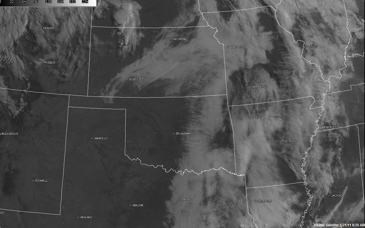
Unlike the past few days, there are no thunderstorms or areas of rain and widespread clouds ongoing along and ahead of these boundaries this morning.  As you can see by the visible satellite image below, skies are largely clear along and ahead of the dryline in Oklahoma & Kansas, as well as ahead of much of the front in Kansas and Nebraska:


Ample sunshine and strengthening Southerly winds will result in a very unstable airmass ahead of the boundaries by afternoon.  By mid to late afternoon, the boundaries are expected to extend along the western edge of the severe weather outlook area from the first image in this post.

Thunderstorms are forecast to initiate from southcentral or southeast Nebraska into central portions of Kansas and Oklahoma by mid to late afternoon.  This activity will move/develop East/Northeast into adjacent portions of eastern Kansas, eastern Oklahoma, western Missouri & western Arkansas into the late afternoon & evening hours.  Large hail, damaging winds and a few tornadoes will all be possible with this activity.

Due to the strength of the instability expected this afternoon, and with winds increasing at all levels of the atmosphere in a manner favorable for severe weather, at least a few of the severe storms are likely to become particularly organized with an enhanced threat of severe weather.  This is especially possible within the red and black hatched areas on the image below:


Hazards with the more mature and organized severe storms in this area would include very large hail, damaging winds and tornadoes.  This includes the Kansas City, Springfield, Joplin, Tulsa, Ft. Smith and possibly the Dallas area (or just to the East).  If you live in or near these areas, please pay particular attention to the weather this afternoon and evening.

In Texas, thunderstorm development is likely to occur southward along the dryline in northcentral Texas by late this afternoon or early this evening.  Additional development will take place further southward along the dryline into central Texas by early evening.  Some of these storms will also become severe, with large hail the primary threat.  Damaging winds and an isolated tornado are also possible with any more organized storms that are able to form, particularly over northeast Texas.

Outflow boundaries were also left behind by thunderstorm activity in central and east-central Texas overnight.  Thunderstorms may also form along these leftover boundaries as well as ahead of the dryline in central and southcentral Texas late this afternoon or this evening.

I believe the severe weather risk area as outlined in the 1st image should be extended further southwest in Texas along the I-35 corridor, to include the Austin & San Antonio areas.  I would expect to see that change made to the mid-morning update from the SPC, based on the surface and model data that is currently coming in.  If you live in the Austin/San Antonio areas, please also keep an eye out for possible severe weather late this afternoon or evening.

Friday, May 20, 2011

Severe Weather Outlook for Today


The above image is the latest Severe Weather Outlook for today from the SPC in Norman.  Severe thunderstorms are possible anywhere within the yellow shaded area.

Similar to last Thursday, thunderstorms are already widespread across much of the severe weather outlook area early this morning, although none of the activity is severe.  Below is the latest radar snapshot, showing a sloppy, heavy rain mess extending from Kansas into much of Oklahoma and northwest Texas:


This activy is generally moving slowly toward the East/Northeast.  Gusty winds and small hail are possible with some of the stronger storms in Oklahoma & Kansas this morning, but widespread severe weather is not expected before Noon.  Very heavy rain will cause flash flooding in some areas.

Further South into Texas, the atmosphere is more unstable, so a few of the stronger storms in northwest Texas may produce larger hail and gusty winds this morning, but an organized severe weather threat is also not expected in this region before Noon.

The big question for today is how much will the atmosphere be able to recover in areas that have widespread rain this morning, and will that allow for severe storms to reform later this afternoon & evening?

The difference between today and last Thursday is that we do have a strong upper level weather disturbance that will move out over the region later this afternoon & evening.  This will provide the uplift needed for additional thunderstorm development along the surface dryline and/or cool front.  The big question is, how unstable will the atmosphere be, which will determine the severity of anything that re-forms.

If the atmosphere is unable to recover over western Oklahoma & Kansas, we could just be looking at a rainy, sloppy mess once again, with some embedded hail.  If, however, the atmosphere is able to recover even in a narrow corridor ahead of the dryline this afternoon, more robust severe weather is possible, with very large hail & damaging winds the primary threats.  Today does not appear to be a day for significant tornado activity in Oklahoma or Kansas at this time (this does not mean that an isolated tornado is out of the question, just that conditions are not favorable for widespread, organized tornado development in this area).

Further Southward, the atmosphere has been "worked over" less in Texas, particularly west-central & southwest Texas.  More vigorous severe thunderstorm development is possible in this area today, which could translate Eastward into the I-35 corridor of San Antonio and Austin.  Large hail and damaging winds would be the greatest threats in this area, along with a chance for an isolated tornado.

There are more variables at play today than in a usual severe weather event, so please "stay tuned" here and with your local media for updates throughout the day if you live in the severe weather threat areas.

Thursday, May 19, 2011

Severe Weather Update for Overnight...and Beyond...


Above is a snapshot from the OKC area radar taken a moment ago.  Thunderstorms have been weakening as they move East/Northeast across the OKC Metro area (into a region with a strong capping inversion) and are no longer severe.  Meanwhile, intense thunderstorms continue in southwest Oklahoma near Lawton.  This activity is also moving East/Northeast with large hail and isolated tornadoes still possible at least for the next hour or so.

The general trend overnight in Oklahoma should be for thunderstorm activity to weaken and/or become less organized across the region.

Meanwhile, in Kansas, the threat of severe weather may extend further into the overnight hours as a series of upper level weather disturbances allows thunderstorms to continue to remain organized in some areas.  Below is the latest Tornado Watch, in effect until 4am for much of western & central Kansas:


Another threat of severe weather will develop on Friday.  Below is the latest Severe Weather Outlook for Friday from the SPC:


In general, severe thunderstorms are possible anywhere within the yellow, banana shaped region from Nebraska and Kansas into Oklahoma and Texas.  the highest risk of severe weather, including very large hail & tornadoes, will take place within the red shaded region on the image below:


The area with the highest risk of severe weather for Friday includes the Dallas/Ft. Worth, McAlester, Tulsa, Ft. Smith, Wichita, Salina, Emporia, Topeka and Kansas City areas.

Stay tuned for updates during the day on Friday, especially if you live in the areas within the red shaded region on the image above.

As heads-up/FYI, the threat of severe weather will shift Eastward into Saturday, as indicated on  the latest SPC severe weather outlook below: