
Above is the latest severe weather outlook for this afternoon & evening from the SPC. They have upgraded portions of Oklahoma, southeast Kansas, southwest and southcentral Missouri and northwest Arkansas to a "Moderate" risk of severe weather (as shown by the red shaded area). This means that areal coverage of severe thunderstorm activity is likely to be more widespread in these areas. A similar risk upgrade was made to portions of the Ohio Valley.
Tornadoes will be possible with severe storms this afternoon, especially within the brown and yellow shaded areas on the image below:

Very large hail will also be another risk. The greatest threat of very large (i.e., baseball size or larger) hail will be within the pink and black hatched area on the image below:

A cluster of strong to severe storms has already formed this morning along the Kansas/Oklahoma border and is now moving across southcentral Missouri, northwest Arkansas and extreme northeast Oklahoma. This activity will continue to progress East/Southeast into adjacent portions of Missouri and Arkansas this afternoon, with damaging winds and large hail the greatest threats.
By mid to late afternoon, thunderstorms are expected to develop in Western portions of the Moderate risk area from southern Kansas into western Oklahoma. This activity will move and/or develop Eastward into adjacent areas of southcentral & southeast Kansas and central and eastern Oklahoma by late afternoon and into this evening. Very large hail, damaging winds and tornadoes will all be possible with this activity.
An outflow boundary is currently flowing southwestward from the thunderstorm complex along the Arkansas/Missouri/Oklahoma border areas, and is moving toward the Tulsa area (thin blue line circled in red on the radar image below):

Updated radar image showing outflow boundary as of 12:55 PM CDT:
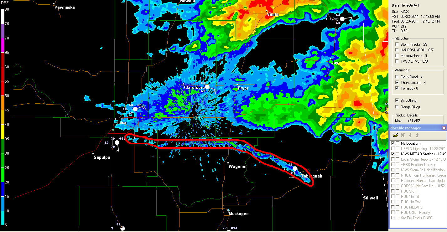
As of 12:50 PM CDT, the Western end of the boundary has become nearly stationary over south Tulsa, while the Eastern end continues to move slowly Southward.
This boundary is likely to become a focus for new thunderstorm development this afternoon across northeast or east-central Oklahoma and west-central or northwest Arkansas and will have to be closely monitored. Any cooler, more stable air that flows into northeast Oklahoma or northwest Arkansas behind this boundary could also influence the severity (i.e., decrease the severity) of any storms that may move in from the West later this afternoon. We'll have to monitor for both of these possibilities this afternoon.
Meanwhile, in north Texas, thunderstorms are developing along the nose of a surge of instability just off the surface level, near the Dallas/Ft. Worth area currently. A Severe Thunderstorm Watch was just issued for this area, valid until 5pm CDT:

Large hail will be the main threat in this area this afternoon. The storms will also move very slowly, which could result in a flash flooding threat over time.
4 comments:
Can you explain outflow boundaries a little more? I noticed the storm to the north of us seemed to be backbuilding, I guess this is what you are referring to? Is outflow what caused the storms that blew through Tulsa about 11pm last night? Those took me by surprise!
Yeah, those phantom storms were a surprise to all of us yesterday evening. That wasn't on outflow, it just appeared to be spontaneous development in the very unstable atmosphere. The dryline had already retreated back West and there was no apparent trigger. Could have been a weak impulse aloft that capitalized on the very unstable atmosphere, but we'll probably never know on that one...
On the radar image in this post, you can see the thunderstorm complex to the North of the radar site. Then you see that thin little blue line running almost East/West through Inola? That is the outflow boundary (circled in red). If you could see the radar looping you'd see the boundary moving Southward away from the thunderstorms. That's like a little mini-cold front being generated by the rain (and/or hail) cooled air from the thunderstorm complex to the North.
Thunderstorms will likely reform along or near that boundary this afternoon (it has since moved further South - currently extending from Tahlequah to just North of Wagoner to Southeast Tulsa), if it holds its definition.
As for the thunderstorms building back on the Western end of the complex, you're right, we call that backbuilding. The bottom line on that is basically that the thunderstorm complex is trying to feed itself by tapping into moist/unstable air that has not been previously disturbed by thunderstorms. This sometimes results in that 'feeder band' of cumulus towers developing into thunderstorms themselves.
Temp has dropped to 68 with a Northeast wind at the Tulsa airport since the outflow boundary passed. Riverside airport in the 80s with a South wind. Will be interesting to see how this boundary plays a role later this afternoon...
So in terms of severe storm development, is that boundary a good thing or a bad thing? I'm just trying to get an handle on where we can expect storms to fire if they do this afternoon and which direction they'll move. I'm more familiar with the classic west to east formation. Thanks!
Planet Pink,
You could potentially have 2 bouts of thunderstorm activity this afternoon and evening.
First, the influence of an upper level weather disturbance is beginning to move into northeast Oklahoma at this time. That is the reason for recent shower and isolated thunderstorm development to your Northwest.
With the West end of the outflow boundary we've been talking about literally cutting Tulsa in half at this hour, thunderstorms could form along the boundary at any time, especially with that disturbance beginning to move in and increase lift across the area. The best chance of this would be after 3pm as daytime heating makes it more unstable along the boundary (which has become nearly stationary).
Second chance will be thunderstorms that form out in western or central Oklahoma late this afternoon moving into your area this evening, in the more "traditional" mode as you mentioned...
Post a Comment