Showing posts with label Severe Weather Updates. Show all posts

Monday, June 6, 2011

Hook Echoes on Radar in Montana


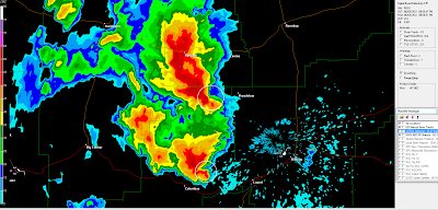
The above image was taken just a moment ago from the Billings, MT radar.  You can see not one, but two supercells with hook echoes (strong radar indication of a possible tornado) just to the West and Northwest of Billings.

These storms are moving East/Northeast at 25 mph, with large hail also indicated.

So far, no on-ground tornado reports have been received with this activity, but these storms will remain dangerous for at least the next few hours.  A Tornado Watch is in effect for much of the region until 1am MDT.

Monday, May 30, 2011

High Plains Action Getting Underway...

***Update, 5:45 PM CDT:
...and the tornado reports come rolling in:


Red icons with Tornado in them are on-ground tornado reports; green icons with 3 dots are large hail reports.

----------------------------------Original Post Below:


The above thunderstorm is rotating strongly on radar, located near the Nebraska/South Dakota border, about 65 miles North/Northeast of Broken Bow.  No on ground reports yet, and believe me, if it were producing something on the ground we'd know it.  According to the spotter/chaser GPS tracker app, there are nearly 75 chasers/spotters observing this storm at the present time (and those are only the one's reporting with GPS tracking).


I suspect this is the same region we'll be deploying to tomorrow with the Radio Shack Team, on the way to meet up with the Weather Channel and "The Great Tornado Hunt 2011".  Tomorrow really looks to be an "off day" in the Plains severe weather wise, but a good day to get into position for Wednesday's severe weather which will likely be in much the same region as today.


We'll be testing out some really cool new equipment that can help you protect your family during severe weather (and even help you get some great video if you're a storm chaser).  I'll be live blogging and sharing photos/video as well.  


Please stay tuned!

Wednesday, May 25, 2011

Tornadoes, Tornadoes, Everywhere - Even in California!


The above radar image shows a tornadic circulation in the storm just South of Chico, California a few moments ago.  Several reports of funnels and brief tornado touchdowns have been received during the past half hour to 45 minutes from this area.  This storm is drifting slowly toward the East.

In other wild California weather news today, moderate to heavy snow is falling a mere 70 or so miles East/Northeast of this area in the Sierra-Nevada range this evening.

Severe Weather Update


Severe thunderstorms continue to advance Eastward into the Ohio, Tennessee and middle to lower Mississippi Valley states this evening.  Many of the storms are showing signs of rotation on radar.  There are 21 tornado warnings currently in effect as of this writing.  

Tornado Watches continue throughout the evening along and ahead of this activity.  If you live in or near these areas, please stay very alert and be prepared to take immediate action if severe weather approaches your area.


Tornadic Storms Moving Into Memphis Area

***Update, 7:47 PM CDT:


I had an update ready to post at 7pm, showing that the severe thunderstorm with strong rotation having moved to the Northwest side of Memphis, but the freaking blogger kept crashing everytime I tried to publish the post.

I'm glad to report that although several funnel clouds and lowerings were reported across Northwest Memphis and Shelby County, no actual touchdowns seem to have taken place.  The above radar image shows that particular storm continuing to advance East/Northeast at 40 mph, along with several others.  Current Tornado Warnings are indicated by the purple polygons.

Please stay alert if you live ahead of this activity this evening.  Tornado Watches continue in effect.


***Update, 6:47 PM CDT:


If you live in Memphis, you should be in your shelters at this time.  The white circled area on the radar image above shows the most likely location for a tornado (very strong circulation still indicated on radar), while the purple circled area shows the most likely location of very large hail of golfball to tennis ball size.

This storm is moving East/Northeast at 40 mph, which will bring the most dangerous portion (with tornado potential) across the Northwest half of Memphis between 7:00 and 7:20 pm.

This storm could deviate more toward the East over the next few minutes, so I highly recommend the entire city of Memphis take tornado precautions at this time.  A funnel cloud was recently reported near Edmondson.  A tornado could be on the ground already, or could form at any time.


***Update, 6:30 PM CDT:


A dangerous thunderstorm with strong low-level rotation on radar continues to move toward Memphis.  Based on the present track, the most dangerous part of this storm will be located over the Northwest side of Memphis at 7pm.  Please don't let your guard down if you live in the Southeast half of Memphis, as even a slight deviation in the movement of this storm could make a big difference.   If you live anywhere in Memphis, seek shelter as this dangerous storm approaches.

It is beyond comprehension to me why the NWS in Memphis has not yet issued a Tornado Warning for the city.  Please don't wait for this to happen, and take immediate steps to get to safe shelter as this storm approaches.

Very large hail can also be expected to the North of the circulation, up to tennis ball size is possible.

***Update, 6pm CDT:


The storm approaching Memphis has slown a bit, but is still moving on a path directly toward the city at this time.  A strong area of rotation is noted on radar very near Forrest City, AR at this time (white circled portion on the right half of the radar image above).

If you live in Memphis, prepare for severe weather, including a possible tornado, between 6:30 and 7pm.

This is a potentially very dangerous weather situation for Memphis.  Please seek immediate shelter as this storm approaches.

------------------------------------------Original Post:


Tornadic thunderstorms are advancing rapidly Eastward toward Memphis at this time.  

In particular, the storm currently approaching Forrest City, Arkansas is currently heading directly toward Memphis at 55 mph.  If the present speed & direction of movement continues, the storm will be entering the city by about 6:15 PM.

A tornado has not yet been reported on the ground with this storm, but it is violently rotating on radar and could produce a tornado at any time.

If you have not left work yet, I would strongly consider staying put.  If you do decide to head home, please make sure that you can get there by 6pm and to a safe shelter should this storm continue on its present path.
Severe Weather Update


The above radar mosaic was taken just a moment ago.  You can see strong to severe thunderstorms, some tornadic. across the Midwest, Tennessee and Mississippi River Valleys.  There are currently 23 Tornado Warnings in effect in this region, as shown by the red outlined areas on the image below.  


Tornado Watches continue for the following areas through this evening:


Severe Weather Heading Toward St. Louis Metro


Severe thunderstorms, some tornadic, are moving East/Northeast toward the St. Louis Metro Area.  Several waves of severe weather will be taking place beginning about 3pm in Western parts of the city, spreading East/ Northeastward throughout the remainder of the late afternoon and into the evening rush hour.


The purple polygons on the above radar image show where Tornado Warnings are currently in effect just West of St. Louis.


If you are at work please be sure to check on the weather before heading home.  In most cases, it would be better to stay at your place of business rather than to venture out into gridlock if a tornado or other very severe storm moves through your area.


Very large hail, damaging winds, and tornadoes are all possible with this activity.

Tornado Watch Update


Tornado Watches are in effect for the above areas in red.  If you live in or South/East of these areas, please stay alert and listen for warnings for your area.

Severe Weather Update - Missouri


The above image was just taken from the Kansas City area radar.  As you can see, several bands of strong to severe thunderstorms are spiraling around an area of low pressure centered very near the Kansas City area at this time.  The small red funnel cloud icons illustrate the number of funnel cloud sightings that took place as some of the same storms moved through Kansas City on the lunch hour.

Only 2 actual touchdowns were reported, one in Overland Park and one in Harrisonville, and those are reported as having been "brief" with no damage or injuries reported (per the media and storm reports) at this time.

The storms heading East currenly toward Boonville and Pilot Grove produced several actual tornado reports near Sedalia.  The rotation appears stronger on this storm than compared to storms that moved through Kansas City, so if you live in the path of this storm (including the Columbia area), please seek shelter as these storms approach.

Severe thunderstorms will continue East across much of Missouri throughout the afternoon, as a strong upper level low pressure system moves across the region.  Tornado Watches continue for the area until 6pm CDT:


The threat of severe weather, including tornadoes, will reach the St. Louis Metro area later this afternoon, most likely after 3-4 pm...toward the rush hour. 

Particularly Dangerous Situation Tornado Watch Issued


The above Tornado Watch was just issued by the SPC, valid until 9pm CDT.  It contains the enhanced wording "This is a particularly dangerous situation...with very damaging tornadoes possible..."

If you live in these areas, please be on high alert this afternoon & evening.

Tuesday, May 24, 2011

Severe Weather Update - Missouri / Arkansas


Thunderstorms are moving Eastward toward western Missouri and western Arkansas.  Despite the time of day, widespread moisture and instability ahead of the activity, as well as a strong upper level storm system moving across the region from the West will maintain the threat of severe weather, including tornadoes, into the overnight hours.

Tornado Watches have recently been issued ahead of this activity over Missouri and Arkansas, as shown by the image below:


Tornadoes are particularly dangerous at night.  If you live in this region, be sure that you have a way to receive warnings during the night.  A NOAA Weather Radio is an excellent tool.  If you don't have one of those available, check to see if a local media or online weather outlet has a text alert service. 

In addition to a threat of tornadoes, very large hail & damaging winds can also be expected in these areas overnight.

Tornado Reported Near Haskell, OK

***Update 9:19 PM CDT:  The circulation has reorganized and strengthened again, and is now located just East of Wagoner.  The storm is moving East/Northeast at 40 mph, and if you live in rural areas to the East/Northeast of Wagoner and over toward and South of Peggs, seek shelter from this storm as a tornado could develop again at any time.  Damage has taken place further West back toward Haskell from this storm and associated tornadoes.


***Update 9:10 PM CDT:  Radar indicates that the circulation associated with the tornado that just moved through the Haskell area has weakened considerably in the last 10-15 minutes.  It is currently located just North/Northeast of Porter, and is moving East/Northeast at 35 mph.


If you live in Wagoner or up toward Peggs, remain alert as this storm could still reorganize again and produce another tornado threat.

-----------------------------------------Original Post:

Spotters report a tornado near Haskell.  Radar is now indicating a debris ball (as noted by the white circle on the image below).  This is a very dangerous situation.  If you live in Redbird, Porter, or Tullahassee and Okay, seek immediate shelter.

Extremely Large Hail, Tornadoes In Metroplex

Softball size hail was recently reported in Irving, with widespread reports of 1 inch to golfball size hail across the Metroplex.  A strong circulation is also indicated on radar near Unveristy Park.  Tornado touchdowns have been reported just North of the Metroplex in the last half hour to hour, and additional touchdowns are possible as these storms move East/Southeast at 15-20 mph.

Tornadic Circulation Nearing Haskell, OK


Strong circulation is still indicated on radar with a storm approaching Haskell.  This storm is now moving more East/Northeast at 35-40 mph.  Haskell, Porter, Okay and Tullahassee are in the path of this circulation.  A tornado could occur at any time.  Please seek shelter if you are in the path of this storm.

Severe Weather Update - Tulsa Metro Area


Strong to severe thunderstorms with very strong, gusty winds of 65 mph and hail up to 1 inch diameter continue to move East out of the Tulsa Metro area at this time.  By 9pm CDT, this activity will have completely moved through the city and off to the East.

On the southern end of the line, a storm North/Northeast of Okmulgee is still showing strong rotation and may produce a tornado, but it will remain South of Tulsa.

Tornadic Circulation Continues Okmulgee County, OK


A strong tornadic circulation continues to be indicated on radar just East/Northeast of Beggs.  It is moving Northeast at 35 mph.  The area from jsut East of Winchester through Haskell is in the path of this storm.

Seek shelter immediately.  This storm is producing a tornado or one is imminent.

Tornado Near Beggs, OK - Moving NE 35 MPH


Radar and spotters indicate a tornado on the ground very near or just Southwest of Beggs, moving NE at 35 mph.  If you live in Beggs, Winchester, or near to Southeast of Liberty as well as portions of extreme southcentral & southeast Tulsa county, seek immediate shelter.

Tornado Update: Beggs, OK / Okmulgee County

Rotation continues to intensify on a storm just Southwest of Beggs.  A tornado is likely occurring or is likely at any time.  If you live in Beggs, seek immediate shelter.  This tornado may be wrapped in rain, and you may not be able to see it.  Preston and Winchester are also in the path of this storm.


Heads-Up: Potential Tornadic Storm SE Creek, Okmulgee, S. Tulsa Counties

The storm southwest of Beggs continues to show organized rotation and now possibly a debris ball.  If th is storm continues on its Northeast path at 35-40 mph, it could eventually affect northern Okmulgee and parts of southern Tulsa County. 

Stay alert and watch this storm closely.  If you are in its path, seek immediate shelter.

Severe Weather Update - Okfuskee / Okmulgee Counties OK

Rotation continues to increase on a severe storm located just Northeast of Boley.  This storm is moving Northeast at 35-40 mph.  If you live in Welty, Nuyaka, Beggs or southeast of Slick, seek immediate shelter as a tornado could form at any time....