Friday, December 23, 2011

#3 Weather Disaster of 2011: Joplin Tornado and Associated Outbreak (May 21-26)...


If you're like me, when you think of May 22, 2011, your mind immediately turns to Joplin, MO and the tragic EF-5 tornado that changed that community forever (photo above courtesy twisterchasers.com).  It's hard to believe that the Joplin tornado was just one of over 180 confirmed tornadoes that took place during the period May 21-May 26, 2011.  The events of those 6 days caused $9 billion in property losses, placing it in the #3 spot for billion dollar weather disasters in 2011.

By far, the Joplin tornado was the deadliest and most damaging event of that week.  Over 160 lives were lost, with over 1,000 people injured.  Thousands of single family residences and hundreds of businesses were destroyed or heavilly damaged.  Insured losses in Joplin are currently estimated to approach $4.5 billion, or roughly one-half of the total damage caused by the events of that week.  

The Joplin tornado cut a swath of damage and destruction from West to East through the center of town:

US Army Corps of Engineers Satellite Damage Survey

NWS Ground-Truth Damage Survey

As you can see by examining the NWS damage survey on the image immediately above, nearly 50% of the tornado's track (which was over 1 mile wide at times) through Joplin produced EF-5 damage, with winds in excess of 200 mph.

The doppler radar velocity (wind speed and direction) image below is tightly zoomed in on the tornadic circulation as it passed the high school:


The radar signature within the white circle indicates a 210 mph wind taking place at the surface at that time.

A "debris ball" signature was frequently noted on radar reflectivity in association with the Joplin tornado, as debris were being lifted up and carried along by the tornado and surrounding circulation:


For more detailed information on the radar imagery associated with the Joplin tornado, please refer to this post.

As alluded to above, the damage in Joplin was extreme.  I was invited to visit the city and survey the damage just one week after the tornado took place.  I was equally horrified and gratified by what I saw.  Horrified by the real-life images of destruction (and yes, death), and gratified to see the "we will survive, we will rebuild" attitude of the vast majority of the folks that I had the pleasure to meet.

I have extensively documented the Joplin tornado event (including a very personal story of survival from a gentleman named Sam) as well as the ongoing recovery in posts throughout the year on this blog.  You can go to my Joplin Tornado Table of Contents post to view and/or read the related articles.

One of the most impressive (if that is the right word) sites that I observed while surveying the damage in Joplin was this brick home that was picked up off of its foundation and moved 8 feet before being sit back down:


You can clearly see the displacement in the photo below.  I have noted the distance from the outer most basement wall to the point where the home was laid back down, which was just over 8 feet in length:


The home above was located to the West of Main Street between 20th and 25th Streets (I won't reveal the exact location out of privacy concerns for the family).  Like the majority of the other homes on the block and in that neighborhood, it had a basement.  Conventional wisdom always says to seek shelter from a tornado in your basement, which is certainly good advice in most cases.  However, in the case of the Joplin, most of the basements in the direct path of the monstrous tornado were filled with debris as homes were lifted off of their foundations.  The image below is a look down into the basement of the same house that was moved 8 feet off of its foundation:


As you can see, bricks, concrete blocks and other parts of the frame crashed down into the basement below.

A similar result took place just two blocks away at Sam's home, but he had a tornado safe room in the corner of his basement which prevented him from being crushed and/or trapped by debris (see his remarkable story here).

I am planning a more detailed post regarding the basement sheltering issue in the near future, but I think the important take away, in a nutshell, is to get underneath a workbench, the stairway or some other sturdy piece of furniture (preferably one that is fastened to the ground) even when you seek shelter in a basement.  If you have room in your basement and can afford it, I would also suggest that you look at having a tornado saferoom built into one of the corners for added protection.

Meanwhile, the recovery in Joplin continues, and will do so for many months if not years to come.  The image below is just one of hundreds of "before and after" scenes that are taking place across the community:


As I mentioned off the top of this post, while certainly the most severe, the Joplin tornado was not the only event to take place during the $9 billion disaster week of May 21-26, 2011.

The events of that week actually began the day before, with an EF-3 tornado near Reading, Kansas:


Severe damage was reported with at least 20 homes destroyed and 1 person killed in Reading.  "Hundreds" of homes and businesses were reportedly damaged in association with the tornado.

The Reading tornado was one of 22 tornado reports that took place on May 21, 2011 (red icons on the image below):


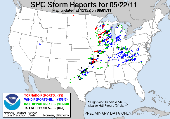
The Joplin tornado on the 22nd was one of 75 reported tornadoes that day:

On Monday the 23rd, the focus shifted to the Midwest and Ohio Valley, where the majority of 22 reported tornadoes took place:


Most of the tornadoes on the 23rd were of EF-0 or EF-1 intensity.  An EF-2 tornado was reported near Kellerville, Pennsylvania, and another was reported near Dover, Tennessee.  There were no deaths or serious injuries on this date.

A very active day took place on Tuesday the 24th, mainly over Oklahoma.  A total of 57 tornado reports were received on that day: 


An EF-5 tornado tracked from near Hinton to Guthrie in central Oklahoma (image below via NWS storm survey):


Nine people were killed as a result of this tornado, which is shown below when it was near Calumet:


Preliminary information from a scan of the tornado by the "Doppler on Wheels" research team suggests that peak winds were in excess of 210 mph with this tornado. This tree on the North side of El Reno was debarked, a phenomenon that we saw a lot of in Joplin, and is indicative of the most intense tornadoes that take place on earth:


When the tornado passed near the Oklahoma Mesonet weather observing station near El Reno, a peak wind gust of 151 mph was recorded, along with a dramatic drop in barometric pressure:


Another intense tornado tracked from near Chickasha to the south side of Oklahoma City (near the Newscastle area) on that day.  It was rated EF-4 intensity and resulted in 1 fatality (image via NWS storm survey):


The photo below shows the tornado when it was near Chickasha:


This particular tornado took a track just South of the devastating tornado that struck Moore in May of 1999.

Another EF-4 tornado tracked from near Bradley to Goldsby, just to the South of the Chickasha tornado track:


The photo below shows that particular tornado near Goldsby:


Late that evening (around Midnight) and into the pre-dawn hours of the 25th, an EF-3 tornado struck and did extensive damage to the town of Denning, Arkansas.  Most of the homes and businesses in Denning were extensively damaged or destroyed, and 4 people were killed.  The same storm produced another tornado a short time later near Clarksville, AR, where 1 person was killed.

Another big tornado day followed on the 25th, with 127 reports received:


While tornadoes were numerous and light to moderate damage was relatively widespread, the intensity of the tornadoes were less on that day - and no one was killed or seriously injured.

The strongest tornado, of EF-3 intensity, tracked from near Grandin to near Buckhorn in Missouri (image below via NWS storm survey):


The tornado rampage slowed considerably by the last day of the event, the 26th, with 16 reports received, mainly across the Ohio Valley and/or Northeast:


There were no fatalities nor any significant injuries on this date, and most of the tornadoes were of EF-0 or EF-1 intensity.  A strong tornado, rated EF-3 intensity, did take place in extreme southeast Louisiana, near Sun.

To return to the original post containing a recap of the record number of billion dollar weather disasters in 2011, please go here.


If you enjoy reading 'The Original Weather Blog', please be sure to "like" our facebook page!

Santa Claus Has Filed His Flight Plan for Saturday Night...

According to this map on the FAA's website, here is the flight plan that Santa Claus has filed for this year:


Once the guy in the big red suit gets underway, you can track him thanks to the folks at NORAD.  There are lots of games for the kids already up on their special Santa Tracker website.  There's even a mobile app for tracking Santa this year!


If you enjoy reading 'The Original Weather Blog', please be sure to "like" our facebook page!

Update on "White Christmas 2011"...

The latest run of the GFS computer model's snow cover forecast valid 6am CST on Christmas morning is shown below:


The depth may be underestimated across portions of western Kansas where there is still quite a bit of snow on the ground, but at least you can get the general idea as to who is likely to have some snow on the ground on Christmas Day.

Note the recent additions over western and northwest Texas, including a patch of accumulated (albeit light) snow to the immediate West of Ft. Worth.

It looks increasingly likely that light snow and/or flurries will also fall even further South in Texas, including parts of the Hill Country to the West of Austin and San Antonio on Christmas Eve.  Accumulation does not appear likely, however it will certainly give a nice, Christmas feel to the air for sure!  I'm keeping an eye on this disturbance and will make a more detailed post later today...


If you enjoy reading 'The Original Weather Blog', please be sure to "like" our facebook page!

Thursday, December 22, 2011

Tornado Watch for Parts of the Deep South...


A Tornado Watch has been issued for much of the southeast half of Louisiana and a large part of Mississippi. It is valid until 1pm CST today.

A large area of shower and thunderstorm activity is moving slowly East across the region this morning.  Stronger storms are located along the leading edge of the complex.  


In this type of situation, brief tornado touch-downs are possible with some of the stronger activity.

A threat of severe weather will spread Eastward across much of the southeast today, as indicated by the yellow shaded area on the image below:


Strong, gusty thunderstorm winds are the main threat with activity today, however isolated, generally brief, tornadoes are also possible with stronger storms.


If you enjoy reading 'The Original Weather Blog', please be sure to "like" our facebook page!

Wednesday, December 21, 2011

Latest Disturbance To Bring T-Storms, Possible Hail to South Texas Tonight, Thursday Morning...


The latest in a series of upper-level disturbances is set to move out over the southern Plains tonight and into early Thursday.

It appears that there will be enough low-level moisture in place across southcentral and southeast Texas for a few strong thunderstorms to develop during the pre-dawn hours of Thursday, into Thursday morning as this disturbance moves through.  Some of the stronger storms may produce hail around one-half inch in diameter, thanks to a layer of cold air just above the surface.

The most likely time for this to take place for southcentral Texas, including the Austin/San Antonio corridor along I-35, would be between Midnight and 6am CST Thursday.  The threat will then shift Eastward into the Houston and southeast Texas area during the 6am to 12 Noon CST time period on Thursday.

More beneficial rain will also come about as a result of this system.  The latest rainfall forecast from the HPC is shown below:


Please note that the vast majority of the rain shown in Texas on the above image will take place after Midnight tonight, into Thursday morning.

Another disturbance will fall in line behind this one, bringing heavy snow to the southern Rockies on Thursday and into Friday, and possibly some wintery weather into the adjacent Plains as well.  I'll have a more detailed post on this disturbance later today...


If you enjoy reading 'The Original Weather Blog', please be sure to "like" our facebook page!

Tuesday, December 20, 2011

Update on Plains Snowstorm...

Overturned vehicle near Garden City, KS


As expected, some very impressive snowfall totals came in overnight and early this morning out across the Plains. The image below shows an estimation of snow depth from the satellite perspective, valid 6am CST this morning:


The darkest blue shading extending from southeast Colorado across southwest Kansas, part of the Oklahoma panhandle and far northeast Colorado indicates 4-10 inches of snow by the satellite's estimation, but there are locally heavier amounts to be sure. 


Below are some specific storm reports of snow depth this morning.  They are organized from highest to lowest and by state.  The snow depth in inches is on the far right hand column (so for example, on the 1st chart below, 20 inches of snow was observed 1 mile West of Walsh, CO).  You can click on each table image to enlarge it.


Let's start with Colorado, which has the overall "winner" so far, with 20 inches reported near Walsh (far southeast corner of the state, near the Kansas border):  


In Kansas, the trophy so far goes to a point near Scott City, with 15 inches:


Here is a video of the blizzard s it was underway in Garden City on Monday (which ended up with 7 inches officially):


The most observed in Oklahoma so far is 10 inches at Kenton, which is near the intersection of the Texas, Oklahoma, New Mexico and Colorado borders.  Reported totals for New Mexico are at the bottom of the same chart, with a maximum of 6.5 inches reported at Cloudcroft:


...and finally the great state of Texas, with a maximum of 6 inches reported near Texline in Dallam County:


The storm is winding down now to be sure, but is not completely over.  As you can see on the latest radar mosaic image below, areal coverage and intensity of the snow is decreasing, but light to moderate snow continues in several bands  from Kansas across northwest Missouri, southern Iowa and southeast Nebraska at this hour:


Travel remains extremely hazardous across western Kansas and eastern Colorado, with most major roads closed.  Please avoid venturing out in these areas at least through tonight.  Blowing and drifting snow will continue for several hours even after the falling snow has come to an end, which will create further hazards.


If you enjoy reading 'The Original Weather Blog', please be sure to "like" our facebook page!

Monday, December 19, 2011

Update on Central / Southern Plains Winter Storm...


As you can see on the radar mosaic image above, snow is widespread and increasing in intensity across the northwestern half of Kansas, much of eastern Colorado, northeast New Mexico and portions of the Texas and Oklahoma panhandle region at this hour.

During the past hour, a report from Springfield, Colorado (near the intersection of Kansas/Colorado and Oklahoma) indicated 9 inches of snow on the ground with drifts up to 2 feet deep.  Much of Lane County, Kansas, including the Dighton area, are reporting 6 inches of snow with blowing and drifting.  


Even more important for travelers, I-70 is becoming very hazardous from near Colby through west of Salina.  Snow is increasing across this region and the roadway will become even more dangerous as the evening progresses, and into tonight.  As snow accumulates, it will begin to blow and drift, causing even more hazardous conditions.

The latest Warning map is shown below:


Blizzard Warnings are shown in orange, with Winter Storm Warnings in pink.  The tan shaded areas represent Winter Weather Advisories.  Please use this map to go to the local National Weather Service office for your area and obtain site-specific warning information.

The GFS forecast model continues to indicate 10-14 inches of snow near the Kansas/Colorado border in southwest Kansas and southeast Colorado by midday Tuesday, with a widespread swath of 8-12 inches from southeast Colorado into southwest and west-central Kansas by the same time:


Here is what the experimental High Resolution, Rapid Refresh (HRRR) model is calling for, as far as snow depth is concerned, valid 2am CST Tuesday morning (scale in inches at bottom of image):


The red areas along the southeast Colorado / southwest Kansas border indicate 12-18 inches of snow being forecast by this model.  The darker orange areas surrounding that, over much of southeast Colorado, southwest and west-central Kansas indicate a forecast of 10-12 inches of snow.

Add strong and gusty North winds to the above and we will continue to see full fledged blizzard conditions across much of the region.  Needless to say, travel is highly discouraged.


If you enjoy reading 'The Original Weather Blog', please be sure to "like" our facebook page!