Monday, December 31, 2012

Latest Winter Storm Sliding East Across the Central Plains / Midwest...

My apologies for not posting about "current" weather for the last few days.  Unfortunately, other commitments have prevented me from doing so.

Late last week I posted about the storm system that is currently affecting the central Plains and Midwest.  This system obviously came out further to the North than it looked like 5 days ago, with the current wintry precipitation swath extending nearly West to East from Kansas into the Midwest and Ohio Valley:


Most of the snow is light to moderate in intensity, with some heavier patches over northcentral and northeastern Kansas.  The airports in Emporia, Topeka, Manhattan and Concordia (all in Kansas) are all reporting 1/2 mile visibility in moderate to heavy snow at this hour, and this heavier snow band is gradually shifting Eastward toward the Kansas City area.

Winter Weather Advisories are currently in effect from the Texas panhandle across most of Kansas, Missouri and into Indiana and southern and central Illinois, as shown in purple on the image below:


The pink shaded area indicates a Winter Storm Warning over portions of western Kansas where stronger winds and heavier snowfall are creating very hazardous conditions.

This system will continue East into the Midwest and Ohio Valley tonight into the first day of 2013, but for the most part, widespread heavy snow is not expected.  This will mainly produce enough snow in the affected areas to cause travel problems and just about keep the kids happy if they haven't seen enough snow so far this season (1-3 inches in most cases within the Winter Weather Advisory areas).

A narrow corridor of freezing rain may cause some light icing from southeast Kansas across southern Missouri and extreme southern Illinois later tonight and early New Year's Day, as indicated by the green and blue shaded areas on the image below:


This could cause locally very hazardous driving conditions in and near this region, so please use extreme caution if you must travel around the area.  I don't believe there will be enough icing to cause major power outages the way it looks right now, but certainly some locations, especially in rural areas, could experience some disruptions in service tonight or early tomorrow.

Please use extreme caution if you're going to be ringing in the new year across the Winter Weather Advisory or Winter Storm Warning areas this evening.  If you live in these areas, it might be a good year just to stay home and celebrate in front of a nice fire!

Whatever you're doing this evening, stay safe, and all the best to you and yours in the new year!

For more information from 'The Original Weather Blog', including shorter, more frequent posts during rapidly changing weather events, please be sure to follow me on facebook and twitter:
 
If you are in need of highly customized, site specific weather forecasts and/or storm warnings for your business, school or event, be sure visit my professional webpage at WeatherGuidance.com.

#1 Most Viewed Blog Post of 2012: The West Liberty Tornado


The #1 most viewed blog post of 2012 covered the tragic tornado event of March 2 in West Liberty, Kentucky.  The post generated more than 200 comments, which is a record for the blog.  Most of the comments stemmed around folks trying to locate friends or family members in the area.  I was humbled and flattered that a lot of folks were able to connect via the blog.

Not only was it the most viewed blog post of 2012, but during the year it has also surpassed the original post on the Joplin Tornado as the #1 most viewed post in the history of the blog.  Over 512,000 unique visitors have read the West Liberty post since it was originally published!

I plan to make a detailed 1 year anniversary post on the event in 2013, which will cover the progress that has been made with respect to the community's recovery since the horrible event of earlier this year.


For more information from 'The Original Weather Blog', including shorter, more frequent posts during rapidly changing weather events, please be sure to follow me on facebook and twitter:
 
If you are in need of highly customized, site specific weather forecasts and/or storm warnings for your business, school or event, be sure visit my professional webpage at WeatherGuidance.com.

Sunday, December 30, 2012

The Tornado Chronicles: Grove Hill, AL Tornado of December 25, 2012...


Another long track tornado took place in association with the Christmas Day Tornado Outbreak of 2012.  This one touched down near Grove Hill, AL, and caused damage up to EF-2 intensity along its 30 mile path.

According to the National Weather Service (NWS) storm damage survey, the tornado initially touched down 8 miles Southwest of Grove Hill, then tracked Northeast for approximately 30 miles before lifting 12 miles Southwest of Camden, AL.  The tornado was on the ground for approximately 40 minutes, and had a maximum damage path width of 150 yards.

Most of the damage associated with this tornado was of EF-0 to EF-1 intensity and mainly consisted of extensive damage to trees (including some older hardwoods that were completely uprooted) and small outbuildings:


The damage that warranted the EF-2 intensity rating is not shown, but was described as being located about 6 miles Southwest of Grove Hill along Highway 43.  Extensive damage was caused to farm equipment in this area, and a grain bin was completely destroyed.  This resulted in the maximum estimated wind speed of 111-135 mph that was assigned to this tornado.

For more information from 'The Original Weather Blog', including shorter, more frequent posts during rapidly changing weather events, please be sure to follow me on facebook and twitter:
 
If you are in need of highly customized, site specific weather forecasts and/or storm warnings for your business, school or event, be sure visit my professional webpage at WeatherGuidance.com.

The Tornado Chronicles: Pearl River County, MS Tornado of December 25, 2012...

Of all of the tornadoes associated with the Christmas Day Tornado Outbreak of 2012, the longest tracked and most intense has been dubbed the "Pearl River County Tornado".  It gets its name from the county in which it initially touched down in extreme southern Mississippi.  

According to the National Weather Service's (NWS) ground surveys, this tornado initially touched down about 2.75 miles Southwest of the town of McNeil, and tracked approximately 61 miles to the Northeast before lifting near the town of McLain in western Greene County, MS (click to enlarge):


This tornado was on the ground for nearly 90 minutes, from 3:10 pm until approximately 4:34 p.m. CST.  

The maximum damage path width associated with the tornado was about 175 yards, with EF-3 intensity damage (estimated winds of around 140 mph) found along Joe Smith Road and Sones Chapel Rd. near McNeil, MS:


As you can see in the photo above, all but 2 small portions of an interior wall collapsed on this home which was made of a wood frame with brick veneer, providing the basis for the EF-3 intensity rating of the tornado.

There was extensive damage classified within the EF-2 intensity category from just Southwest of McNeil to just northeast of McNeil, as shown in the damage photos below (from the NWS survey):


From there, the tornado weakened after crossing Highway 11, causing mostly EF-0 to EF-1 intensity damage to trees and damage to some roofs:


The damage survey in Pearl County indicated that 22 homes were completely destroyed, 8 homes had major damage and 25 homes had minor damage.  Approximately 8 people were injured, but none seriously thank goodness.  

The tornado reintensified to EF-2 intensity near Red Hill Church Road along the Pear River / Stone County lines, and produced fairly extensive EF-2 damage as it crossed Will Lee Road in Stone County.  Several mobile homes were completely destroyed at this point along the tornado's path, with much of the debris completely carried away:


Shortly after crossing Will Lee Road in Stone County, the tornado weakened once again, producing mostly EF-0 and EF-1 intensity damage, mainly in the form of downed trees and tree limbs along much of its track through Forrest County.

By the time the tornado reached extreme northeast Forrest County, approaching the Perry County line, it began producing EF-2 intensity damage once again near the intersection of Pap Armstrong Road and Jay Bailey Road.  This included the snapping of utility poles as well as complete to near complete destruction of several mobile homes:


As the tornado crossed the Perry County line, it caused mainly EF-0 to low end EF-1 damage to trees until it reached the State Highway 29 and Lula Cooley Road areas in the northeast part of the county.  Here, additional utility poles were snapped in half or completely uprooted and extensive EF-2 damage was done to additional mobile homes in the area:


The tornado then weakened back to EF-0 to low end EF-1 intensity, mainly causing damage to trees and tree limbs as it crossed the Greene County line and lifted just to the North/Northeast of the town of McLain.

Despite the fact that the tornado was on the ground for nearly 90 minutes and crossed I-59 as well as Highway 49 in Mississippi, no photos or videos of the tornado itself have been revealed so far.  We will be sure to post any updates, including photos of the actual tornado, if and when they become available...

For more information from 'The Original Weather Blog', including shorter, more frequent posts during rapidly changing weather events, please be sure to follow me on facebook and twitter:
 
If you are in need of highly customized, site specific weather forecasts and/or storm warnings for your business, school or event, be sure visit my professional webpage at WeatherGuidance.com.

#2 Most Viewed Blog Post of 2012: Wichita, KS Tornado of April 14th...


The 2nd most viewed blog post of 2012 covered the April 14th tornado that struck Wichita, KS.  

For more information from 'The Original Weather Blog', including shorter, more frequent posts during rapidly changing weather events, please be sure to follow me on facebook and twitter:
 
If you are in need of highly customized, site specific weather forecasts and/or storm warnings for your business, school or event, be sure visit my professional webpage at WeatherGuidance.com.

Saturday, December 29, 2012

#3 Most Viewed Blog Post of 2012: Birmingham, AL Tornado of January 23rd...


The third most viewed blog post of 2012 covered the January 23rd tornado in Birmingham, Alabama.  


For more information from 'The Original Weather Blog', including shorter, more frequent posts during rapidly changing weather events, please be sure to follow me on facebook and twitter:
 
If you are in need of highly customized, site specific weather forecasts and/or storm warnings for your business, school or event, be sure visit my professional webpage at WeatherGuidance.com.

Friday, December 28, 2012

#4 Most Viewed Blog Post of 2012: Algarve, Portugal Tornado of November 16th...


The fourth most viewed blog post of 2012 covered the tornado that struck the Algarve region of Portugal on November 16th.


For more information from 'The Original Weather Blog', including shorter, more frequent posts during rapidly changing weather events, please be sure to follow me on facebook and twitter:
 
If you are in need of highly customized, site specific weather forecasts and/or storm warnings for your business, school or event, be sure visit my professional webpage at WeatherGuidance.com.

Thursday, December 27, 2012

Major New Year's Snowstorm Appears Likely for the Southern Plains...

If you live in the southern U.S. and didn't get your wish for a white Christmas, you have another opportunity for accumulating snow (possibly heavy) coming up soon!  It appears that a major winter storm system will take shape and impact the region around the New Year's holiday time period early next week...

A vigorous middle and upper-level weather disturbance is currently organizing off of the coast of the Pacific Northwest:


This disturbance will generally move Eastward today and Friday and then take a dive toward the Southeast over the weekend, with the energy forecast to move down into the southwestern U.S. and northwestern Mexico by 6pm CST on Sunday evening:


The system is likely to become well organized by that time, producing heavy snow across the southern Rockies over the weekend, with precipitation spreading East into the adjacent Plains of New Mexico, northwest Texas and western Oklahoma by New Year's Eve and New Year's Day.

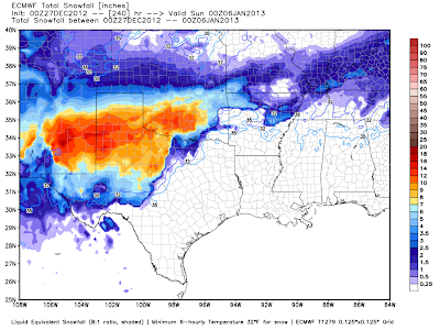
The European (ECMWF) computer forecast model suite is the most aggressive with snowfall amounts of the major models so far.  Here are its current snowfall projections valid at 6pm CST on Monday:


...at 6pm CST Tuesday:


...and at 6pm CST Wednesday:


As you can see, the model is forecasting the system to slow down considerably, dumping heavy snow across much of the same area for 2-3 days before lifting out to the East next weekend.  The snowfall forecast image below is valid at 6pm CST on Saturday, January 5th and shows locally heavy snow spreading Eastward into Oklahoma and northwest Texas by that time:


On the warm side of the system, beneficial rain is likely to fall across much of central and eastern Texas early next week, with heavy rainfall possible over southeast and east-central Texas by Tuesday:

ECMWF Rainfall Forecast; 24hrs. Ending 6pm CST Monday, 12/31

 ECMWF Rainfall Forecast; 24hrs. Ending 6pm CST Tuesday, 1/1

We obviously still have quite a bit of time to monitor this situation, but if you live or have travel plans into the indicated areas for late this weekend into next week, keep an eye on the weather and check back for the latest updates.  It would also be a good idea to take some time between now and Sunday to stock up on some extra non perishable food and other supplies like batteries, candles and firewood, just in case.

For more information from 'The Original Weather Blog', including shorter, more frequent posts during rapidly changing weather events, please be sure to follow me on facebook and twitter:
 
If you are in need of highly customized, site specific weather forecasts and/or storm warnings for your business, school or event, be sure visit my professional webpage at WeatherGuidance.com.

#5 Most Viewed Blog Post of 2012: Hampton, VA Tornado of June 1st...


The fifth most viewed blog post of 2012 covered the tornado and waterspout that struck the Hampton, VA area on June 1st.


For more information from 'The Original Weather Blog', including shorter, more frequent posts during rapidly changing weather events, please be sure to follow me on facebook and twitter:
 
If you are in need of highly customized, site specific weather forecasts and/or storm warnings for your business, school or event, be sure visit my professional webpage at WeatherGuidance.com.