A vigorous middle and upper level weather disturbance is taking shape across the Great Basin late this afternoon. This system is poised to lift East/Northeastward over the next 24-60 hours, and will spread a variety of wintry weather across the Rockies, adjacent Plains and eventually into the Midwest.
After having been locked in a "snow drought" for much of the season thus far, this system will strike a particularly fierce blow to the region. A variety of Winter Weather Watches, Warnings and Advisories are in effect, as shown on the latest updated weather hazards image below:
A Blizzard Warning is shown in orange across eastern Colorado, western Kansas and southwest Nebraska, where a combination of heavy snow and strong, gusty winds will produce white out conditions at times on Wednesday and Wednesday night.
The latest high resolution computer forecast model data is calling for 6-12 inches with locally higher amounts in this region through 6pm CST Wednesday evening:
...with the heavy snow band forecast to shift Eastward into much of Iowa, northern Illinois and central into southern Wisconsin by 6pm CST on Thursday:
Travel delays will be widespread across this region beginning tomorrow and continuing into Thursday. If you have flights into or out of Chicago, Omaha, Des Moines or Kansas City, I strongly suggest checking ahead for delays and/or cancellations before venturing out to the airport.
Much colder air will also invade the central and southern Plains, Midwest and Mississippi Valley region in association with this system, which will especially come as a shock after the unseasonably (and in some cases, record) warm conditions of the last few days.
Take a look at the temperature contrast from the departure from normal values for today and Wednesday:
...and then Thursday:
This strong storm system and the associated temperature contrast will produce a threat of strong to severe thunderstorm activity across the middle and lower Mississippi Valley region on Wednesday afternoon and evening:
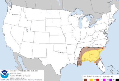
...which will shift into the southeast U.S. on Thursday afternoon and evening:
There are strong indications that this is just the first in a series of strong storm systems that will affect the U.S. over the coming few weeks. We are also closely monitoring a developing system for the Christmas Day time period next week, and the New Years Day time period the following week. Both would potentially impact the central and southern U.S., so stay tuned for details!
For more information from 'The Original Weather Blog', including shorter, more frequent posts during rapidly changing weather events, please be sure to follow me on facebook and twitter:
If you are in need of highly customized, site specific weather forecasts and/or storm warnings for your business, school or event, be sure visit my professional webpage at WeatherGuidance.com.


No comments:
Post a Comment