A strong tornado struck the Hazelwood and Florrisant areas of northwest St. Louis during the evening hours of Wednesday, April 10, 2013. The preliminary National Weather Service (NWS) damage survey has rated the tornado EF-2 intensity, with maximum winds estimated at 115-125 mph.
The tornado initially touched down at approximately 8:00 PM CDT in the Bridgeton area, near I-270 and St. Charles Rock Road. It then continued to the East/Northeast for approximately 7 miles before lifting just East of St. Ferdinand Park in Florrrisant at approximately 8:05 PM CDT:

The tornado was as many as 500 yards wide at one point, and caused numerous injuries but, thankfully, no fatalities.
Below are some damage photos that were initially provided via social media:


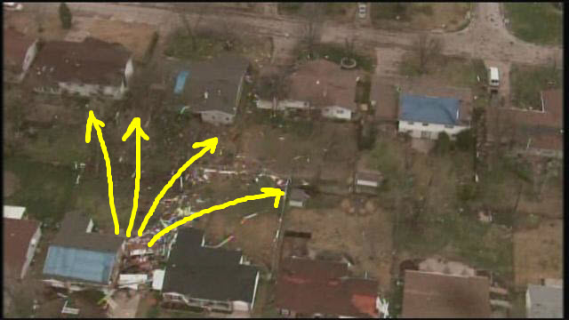
The following aerial photos were provided by KSDK TV, and show a variety of both tornado and straight line and/or microburst wind damage across the area:


Particularly within the last picture, you can see how the debris (including what appears to be several trees) were spread out like a fan. This is suggestive of very strong, microburst type winds:
Indeed, the Terminal Doppler Weather Radar (TDWR), an extra sensitive radar located near the St. Louis Airport designed to detect wind shear and/or microbursts for aviation concerns, detected very strong winds of 70-80 mph in several pockets across the area that evening:

If you're interested in this tornado event, please bookmark this post and check back for updates that will be forthcoming as more details are obtained over the coming days.
For more information from 'The Original Weather Blog', including shorter, more frequent posts during rapidly changing weather events, please be sure to follow me on facebook and twitter:


Coming April, 2013: "The Tornado Chronicles" full website!
• Interactive tornado database back to 1950 (earlier years coming soon)
• Interactive radar with live warnings and street-level zoom
• Tornado safety, preparedness and education
• Daily tornado/severe weather outlook
• Photos, videos and more!
3 comments:
This from Chicago. I followed the action on KMOX driving home Wednesday night and was impressed with the quality reporting and detail, particularly before the tornadoes even touched down. Then frustration set in as I tried for two days to get some sane reporting on these storms and finally stumbled onto this superior site. Much appreciated!
Wayne Brasler
Chicago
Wayne,
Thanks very much for your kind words, and for reading the blog!
Rob
Hi nice reading yyour post
Post a Comment