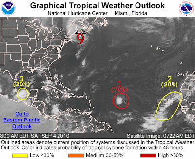
Earl:
The Boston area dodged a major bullet overnight as Earl turned toward the Northeast a little earlier than expected, sparing the region of any extended periods of strong wind. Earl has since been downgraded to a tropical storm, and will race Northeast into Nova Scotia this morning.
Disturbance #1 (formerly Gaston):
The red encircled area with a "1" shows the remnants of Tropical Storm Gaston. The 70% figure indicates the likelihood, in the National Hurricane Center's opinion, that Gaston will regain at least Tropical Depression status within the next 24 hours.
Disturbance #2:
The yellow encircled area shows a strong tropical disturbance moving West off the coast of Africa. It is likely to become better organized by Sunday.
Disturbance #3:
Look for a separate post on this feature shortly. It will probably titled something like "Texas Rainmaker".
Where's Fiona??
In case you're wondering...Fiona dissipated to the Northeast of Bermuda overnight. (You can still see a faint puff of clouds South of Earl and North of Bermuda if you look closely at the above satellite picture).

No comments:
Post a Comment