Below are reflectivity and velocity images as depicted by the Fort Smith area doppler radar:
As a reminder, on the velocity (wind motion) image, red and orange colors show winds blowing away from the radar, while greens and blues show winds blowing toward the radar. The radar is located just off of the image, toward the bottom center. You can see where the bright blue (nearly white) colors line up immediately parallel to the bright red (nearly pink) colors near Cincinnati, which shows where the radar indicates very strong rotation.
The tornado first touched down just Northeast of Westville, OK at about 6:05 am CST. Sporadic damage to homes, trees and power lines were reported as the tornado raced Northeast toward the Arkansas line. The damage photo below was taken near Westville, by the NWS Tulsa survey team:
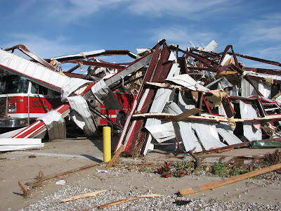
Preliminary survey information indicates that the tornado reached EF3 strength as it approached Cincinnati, AR. Three residents of that community lost their lives, and at least 7 others were injured. One of the fatalities was to a rancher who was in a barn tending to his cattle. The other two fatalities were in a mobile home that was destroyed. Extensive damage to homes (both regular frame and mobile) was reported. Below are a few photos collected by the NWS Tulsa survey team:
The last photo is of the Cincinnati Volunteer Fire Department building, which as you can see was completely destroyed by the tornado.
It is estimated that the tornado grew to 300 yards wide while tracking through Cincinnati, then grew to 500 yards wide before crossing into Benton County, AR at approximately 6:17 a.m. CST. Preliminary survey information indicates that the tornado dissipated about 3 miles Northwest of Tontitown, just before 6:30 a.m. CST.
There are unconfirmed media reports of debris from Cincinnati being carried as far North as the Northwest Arkansas Regional airport near Bentonville (which is approximately 6 miles north of where the tornado was reported to have dissipated). If confirmed, this will be the 2nd case of a tornado or tornado-associated debris impacting a general aviation airport yesterday. More on the other airport related tornado (near Jackson, MS) in another posting later today...


4 comments:
My sons live on my 40 acres about 5 miles east of Westville right on highway 62. My DIL was out feeding my horses, saw the cell and took her kids into an old metal storage tank my son cut a door into, since they live in mobile homes and have nowhere else to hide. He grew up with Nathan Lawrance, pictured on the BBC news feed. No damage to our place since the storm passed them by, but the last near miss was one in Tahlequah summer before last. My son just happened to be in town looking for work. Small tornadoes come through on a regular basis. In the years I lived there before, I saw many, & the results of many, most of which did not touch down. I hope I can find the means to get us a storm shelter soon, as I'm retiring & moving back next year.
Pardon, I meant WEST of Westville...
I would have thought EF-4 given the damage.
Dear Anonymous, thanks for your comment. There are a lot of storm shelter solutions out there now days, and they are becoming more affordable all the time. Visit www.smartsafeshelters.com or www.groundzeroshelters.com, just to name a couple. (I just did a google search, but am familiar with both of those companies).
Post a Comment