Based on preliminary storm reports and radar information, it appears that one or more tornadoes tracked Northeast from just north of Terry along I-55 to near Byram, then on Northeast across portions of Richland and Pearl. Significant damage was reported to both the Kroger Grocery Store and the Tinseltown Movie Theater in Pearl. Media reports also indicate that a tornado either tracked directly across the runway, or at least threw debris onto the runway at the Jackson airport, before dissipating or moving on to the Northeast.
The map below is an approximation only of the general track of the tornado or tornadoes, based on storm reports, damage photos and radar data. The data on the left side of the map are actual storm reports that were received last night (click to enlarge the map):
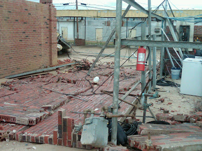
Below are some photos collected by various media outlets today, showing the damage in and around the region:
Unknown structural damage near Byram
Unknown structural damage near Pearl
Tree damage near Pearl
Damage to a car wash near Pearl
Surprisingly, the above are about all of the photos I can come up with so far. Hopefully more will be available by tomorrow (along with the NWS survey information). I'll make another post/update at that time.
I also wanted to insert the radar images below. They appeared in my original post last night, but are well worth an encore. Remember, they are split screens with reflectivity (rain, hail, etc.) on the left half of the image and velocity (wind motion toward the radar in blues & greens and away from the radar in reds and oranges) on the right half of the image. Look at the intense rotation near Byram at 4:56 PM CST (as annotated by the yellow circle on the right hand side of the image):
...and the same circulation between Pearl and the Jackson airport at 5:15 PM CST (again, annotated by the yellow circle on the right hand side of the image):
I have not heard of any fatalities in Mississippi so far, and that is an amazing testament to the warning process - particularly considering the fact that all of this took place on what would historically be considered a "near zero" threat day for tornadoes...
More information to follow when the survey data comes in...


1 comment:
Greetings Rob White from Wa.state: i just wanted to say how comforting it is to have read what you've written thus far, and i'm standing by waiting for your next update. It is SUCH a relief to have found your site, to me during this time. There is a very dear friend of mine and her family that live in Jackson, Mississippi and please know that The Original Weather Blog and you are like long hands, trusted friends; reaching through, online, with news, information, photos and updates. Words can't express my gratitude of being privy to what's actually going on, i'm so thankful to have discovered your source of knowledge, and be relieved by it as i'm so far away.
Post a Comment