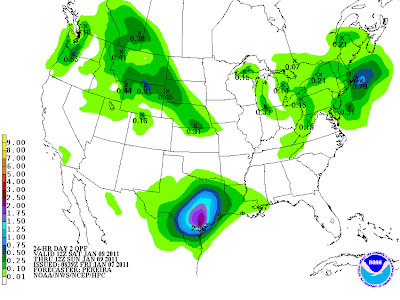
The above image shows the HPC forecast of rainfall for the period 6am CST Saturday to 6am CST Sunday (this weekend). It won't actually rain during that entire 24 hour period. In fact, most of the rain will take place after 6pm on Saturday, through early Sunday morning. So this will be a "nighttime" event for most of the region (which is somewhat unusual for this time of year).
With much of the region at or near drought (or at least very dry) conditions, the rain will be very welcome. As you can see on the map, widespread amounts of 1-2 inches are forecast for roughly the southeast half of the state.
The cause of the rain (some of which will be accompanied by thunderstorms), is a vigorous upper-level weather disturbance that is forecast to lift across the region Saturday night and early Sunday. The image below is the GFS computer model, valid 6am CST on Sunday morning:
The image shows the computer forecast model's impression of what roughly the "middle" levels of the atmosphere will look like on Sunday morning. The bright yellow shaded area (with the "X"s inside) shows the disturance (also called a trough of low pressure) that will be moving across the state at that time. Most of the heavier precipitation will occur ahead of it.
Some of the thunderstorms could actually be at or near severe limits across portions of southeast Texas, despite the fact that they will be occurring at night. Notice the nearly Northwest to Southeast orientation of the trough/disturbance? In meteorology we refer to this as a "negatively tilted trough". Not to get too technical (maybe I'll go into this in greater detail in a later post, but for now you can go here), but a negatively tilted trough has much more "uplift" and other dynamics associated with it, which are two key ingredients for heavier precipitation and stronger thunderstorms.
I'll make another post regarding this system later today and/or Saturday to give you the latest on what any specific severe weather threats may be unfolding. For now, definitely plan on beneficial rain for much of the central and eastern two-thirds of the Lone Star State late Saturday and early Sunday (oh, and don't forget about that little cold blast that is still on track for the first of the week).


No comments:
Post a Comment