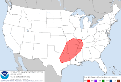
A strong middle and upper-level storm system will combine with an increasingly well defined cold front at the surface to produce a severe weather threat across portions of the Southern Plains and Mississippi Valley regions on Tuesday and Tuesday night, perhaps into early Wednesday.
The latest severe weather outlook from the Storm Prediction Center (SPC) in Norman, OK is shown below. First, for Tuesday:
...and for Wednesday:
While all of the exact details are not yet clear, it appears likely that thunderstorm development will take place ahead of the cold front during the afternoon hours on Tuesday from southwest Missouri into northcentral Texas.
At this time it appears most likely that the majority of the storms will form into one or more lines or line segments, which would tend to suggest that the primary severe weather potential will be damaging wind gusts. It is possible that storms could take on a more isolated configuration on the southern end of the axis, across northcentral and northeast Texas and perhaps southeastern Oklahoma late Tuesday afternoon and Tuesday evening. Any storms that are able to remain more isolated and become well organized would have a better chance of producing a tornado.
The activity will move and/or develop toward the East/Northeast during the evening hours, spreading into the middle and lower Mississippi Valley region on Tuesday night. Damaging wind gusts will likely be the primary threat during this period of time.
Rainfall forecast 6am Tuesday-6am Thursday
Some of the storms are likely to remain organized enough to continue moving East into portions of the Deep South on Wednesday morning, primarily within the purple shaded area on the 2nd map above, with damaging wind gusts the primary threat.
A major limiting factor for organized tornado development with this system on both Tuesday and Wednesday is the fact that the wind profile in the lower through middle atmosphere will be nearly parallel, and the low level winds are not forecast to be that strong. More of a "turning" profile is typically needed for organized tornado development, and a strong, turning low level wind field increases that threat. This will need to be monitored, and if it appears that the lower level wind profile will become stronger and/or more Southeasterly in any particular locations, a greater tornado threat could develop.
If you live across the areas shown above, please pay attention to the weather on Tuesday afternoon through Wednesday morning. Stay tuned for updates as the event approaches.
For more information from 'The Original Weather Blog', including shorter, more frequent posts during rapidly changing weather events, please be sure to follow me on facebook and twitter:
Coming March 2013: The Tornado Chronicles full website!
Including information on every U.S. tornado since 1950, tornado safety, preparedness and education as well as interactive radar, tornado outlooks, watches and warnings, and much more! Please show your support and follow The Tornado Chronicles on twitter and on facebook for the latest updates on tornadoes and the upcoming website!


No comments:
Post a Comment