Low level moisture is streaming rapidly Northward from the Gulf of Mexico today, as shown by the current surface dewpoint and wind map above.
This influx of moisture will combine with the first in a series of middle and upper level weather disturbances to produce scattered thunderstorm development from southwestern Oklahoma up through southeast Kansas and southwest Missouri later tonight. This will take place well in advance of the "main event" that is forecast for tomorrow.
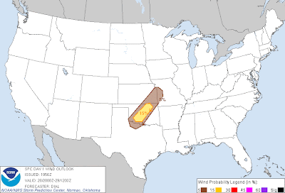
The latest update from the Storm Prediction Center (SPC) has placed a narrow axis from extreme northwest Texas into west-central Missouri under a low-end severe weather risk for tonight:
In this type of situation, hail is typically the greatest threat, although I cannot completely rule out an isolated instance of a damaging wind gust or even an isolated tornado (mainly because the low-level winds are not forecast to shift back to the Southwest-in more of a linear fashion-until after dawn on Tuesday).
I believe the most likely time for storms to develop in this region will be after Midnight, and through the pre-dawn hours Tuesday. They will move quickly toward the North/Northeast.
This is by no means a situation where you should worry about "sleeping in the basement" tonight, but do keep your weather radio or weather radio alert app handy just in case a bulletin is issued that you need to hear about...
For more information from 'The Original Weather Blog', including shorter, more frequent posts during rapidly changing weather events, please be sure to follow me on facebook and twitter:
Coming March 2013: The Tornado Chronicles full website!
• Interactive tornado database back to 1950 (earlier years coming soon)
• Interactive radar with live warnings and street-level zoom
• Tornado safety, preparedness and education
• Daily tornado outlooks/threat index
• Photos, videos & more!


2 comments:
Do you believe there is still a threat for cntrl tx?
Ryan, thanks for the comment/question.
It'll be an all or nothing proposition to be sure. Morning NAM model showed nice isolated/scattered storms from San Antonio to Austin around 4pm tomorrow, but midday run keeps them from Georgetown on Northward. Will be interesting to see what this evening's run looks like.
Like I mentioned yesterday, if storms are able to form, the severe threat will be relatively high, especially just East of I-35. Tornado potential would be (relatively) higher down this way too, as surface winds will be more Southerly than Southwesterly further North...
Post a Comment