Computer model forecast data continues to come into better agreement that a significant episode of severe weather is likely on Tuesday afternoon and evening.
The latest severe weather outlook from the Storm Prediction Center (SPC) is shown below, valid Tuesday and Tuesday night:
The latest severe weather outlook from the Storm Prediction Center (SPC) is shown below, valid Tuesday and Tuesday night:
Severe thunderstorms are possible anywhere within the brown, yellow and red shaded areas, with the highest potential forecast within the yellow and red shaded areas. This includes the DFW Metroplex region, Shreveport, Little Rock, Memphis, Paducah and St. Louis.
Thunderstorms are forecast to develop along and ahead of a sharpening cold front during the afternoon hours, near the western edge of the outlook area. The activity will then shift East and Northeast during the remainder of the afternoon and into the evening Tuesday.
I mentioned yesterday that the forecast wind profile in the lower and middle levels of the atmosphere suggests that damaging wind gusts will be the primary severe weather threat, and this continues to be the case as of this writing.
Based on current trends, I would expect one or more significant lines of thunderstorms to form along and ahead of the front in the indicated areas, with the potential for widespread, significant wind damage. While at least a few tornadoes are certainly possible, I do not expect them to become the dominant severe weather mode with this event.
Under this type of scenario, the best chance of tornadoes would come within the rotating comma head of bowing line segments, similar to the one circled in white on the image below:
These types of tornadoes are typically "weaker" and short lived, compared to their supercell counterparts. None-the-less, a tornado is a tornado, and it doesn't matter how "weak" or short lived it is if striking your home or business, so please handle the situation accordingly if you find yourself in a warned area.
Any storms that are able to form out ahead of the line or lines and remain rather isolated could become organized enough to produce a higher tornado threat. At this time, I believe the best chance of this taking place would be within the red shaded area on the map at the top of the post - perhaps extended back to the South/Southwest a bit more in Texas toward the I-35 corridor.
Some of the more subtle details will become clearer over the next 24-36 hours, and hopefully we'll have a better idea as to any enhanced tornado threat by tomorrow.
The activity is then forecast to spread Eastward into the Appalachians and the southeast U.S. on Wednesday, with the highest severe weather threat shown in red on the image below:
Once again, damaging wind gusts appear to be the greatest threat on Wednesday as well.
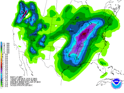
In addition to the threat of severe weather, this system will produce widespread, locally heavy rain across a large portion of the Mississippi River Valley, Midwest and at least the western Ohio Valley through early Wednesday:
If you live across the severe weather threat areas for Tuesday and Wednesday, please remain alert. Take the time now to review severe weather safety and preparedness tips and identify your best sheltering option so that you can move there quickly if threatening weather is observed or a warning is issued for your area.
For more information from 'The Original Weather Blog', including shorter, more frequent posts during rapidly changing weather events, please be sure to follow me on facebook and twitter:
Coming March 2013: The Tornado Chronicles full website!
Including information on every U.S. tornado since 1950, tornado safety, preparedness and education as well as interactive radar, tornado outlooks, watches and warnings, and much more! Please show your support and follow The Tornado Chronicles on twitter and on facebook for the latest updates on tornadoes and the upcoming website!


4 comments:
i guess the chances for severe weather are low in central texas and the nws is more concerned on nrn texas and oklahoma right? ive been wantin to see some srvere weather since last year. I hope this year will bring a lot of severe weather.
Ryan,
Thanks for the comment/question.
This is likely to be one of those "all or nothing" situations for the Austin-San Antonio metro areas. Storms will either develop overhead late Tuesday afternoon, or develop to our immediate East late Tuesday afternoon / early Tuesday evening.
Any storm that develops will have high severe potential, hence my "all or nothing" terminology.
Ironically, we would stand a higher tornado chance than any location further to the North/Northeast due to our forecast wind profile, but that's contingent on thunderstorms being able to develop in the first place.
Right now, I'd place the chance of a thunderstorm at 30-40% in Austin and 20-30% in San Antonio. The chance of severe weather is about double that, assuming storms form.
Stay tuned for more tomorrow!
thanks Rob im a really commited storm spotter im only 14 and i forecast a lot. I check your site every day. yeah i agree it probably will be either a hit or a complete bust. also you should write a story on the upcoming drought conditions i believe they look terrible.
Ryan Hearne So basicly what your saying is that though with a 40 percent chance it would be likely that a strong to severe storm or two will be relevant in central texas, me and my dad will probably be on our way near dallas tomorrow if the pops go down for austin which it sits at a 30 from noaa. I think a fast moving squall line will develop at around 3-4:00 pm and become more origanized , so well chase northeast of dallas. do you think this is a good area to chase? its a pretty tricky decision whether to stay and chase here or break and head out torwards oklahoma, and extreme n/ern tx.
Post a Comment