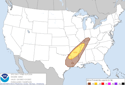
Above is the latest severe weather outlook for today and tonight from the Storm Prediction Center (SPC) in Norman, OK. Severe storms are possible anywhere within the brown shaded area, with the best chance from the Arklatex region into the Missouri bootheel (as shown in yellow).
Damaging wind gusts will be the primary threat, however a few tornadoes are also possible, especially within the brown shaded area on the image below, which includes Shreveport, Texarkana, Little Rock and Memphis:
Some isolated instances of large hail may also occur, but that won't be a widespread threat today.
The most likely time for severe storms will be from mid-afternoon into early tonight, so please pay particular attention to the weather during those times if you live or have travel plans across the indicated area.
Locally heavy rainfall is also likely across much of the same region, particularly from Arkansas on North/Northeastward where 4 inches (or locally more) of rain is likely today and tonight:
Flash flood watches are in effect across much of the region through Sunday.
For more information from 'The Original Weather Blog', including shorter, more frequent posts during rapidly changing weather events, please be sure to follow me on facebook and twitter:
If you are in need of highly customized, site specific weather forecasts and/or storm warnings for your business, school or event, be sure visit my professional webpage at WeatherGuidance.com.


No comments:
Post a Comment