A vigorous weather disturbance in the middle and upper atmosphere will lift out from the central Rockies into the Plains late Wednesday through Friday of next week, producing a swath of potentially heavy snow across the central Plains and parts of the Midwest.
As of today, the U.S. based GFS computer model is forecasting the heaviest snow to extend from much of central and eastern Nebraska into Iowa, northern Missouri and into portions of Illinois, as shown on the total snowfall forecast map below ending 6pm CST next Friday, February 22nd:
The impact from this storm system is obviously a ways out, and as you would expect at this time range there are varying computer model solutions, such as the ECMWF model that is forecasting heavy snow to extend as far South as the Oklahoma/Kansas border and southern Missouri during the same time period:
Stay tuned on this one. While it's difficult to say at this time exactly where the heaviest snow will fall, a significant winter storm is likely from the central Plains into the Midwest from Wednesday night through Friday of next week.
At the same time, on the Southern end of the system, a potentially significant severe weather threat is likely to develop across portions of the lower Mississippi Valley and Deep South, especially on Thursday (the way it appears right now, anyway).
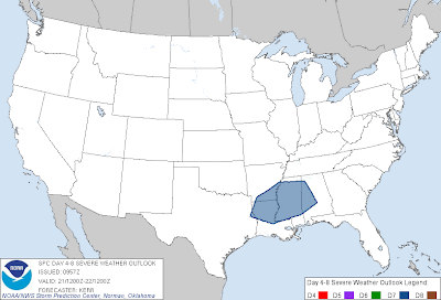
The latest outlook from the Storm Prediction Center (SPC) in Norman, OK is forecasting a risk of severe weather on Thursday, February 21, in the area shaded in blue on the image below:
Please show your support and follow The Tornado Chronicles on twitter and on facebook for the latest updates on tornadoes and the upcoming website!
As of today, the U.S. based GFS computer model is forecasting the heaviest snow to extend from much of central and eastern Nebraska into Iowa, northern Missouri and into portions of Illinois, as shown on the total snowfall forecast map below ending 6pm CST next Friday, February 22nd:
The impact from this storm system is obviously a ways out, and as you would expect at this time range there are varying computer model solutions, such as the ECMWF model that is forecasting heavy snow to extend as far South as the Oklahoma/Kansas border and southern Missouri during the same time period:
Stay tuned on this one. While it's difficult to say at this time exactly where the heaviest snow will fall, a significant winter storm is likely from the central Plains into the Midwest from Wednesday night through Friday of next week.
At the same time, on the Southern end of the system, a potentially significant severe weather threat is likely to develop across portions of the lower Mississippi Valley and Deep South, especially on Thursday (the way it appears right now, anyway).
The latest outlook from the Storm Prediction Center (SPC) in Norman, OK is forecasting a risk of severe weather on Thursday, February 21, in the area shaded in blue on the image below:
Both damaging winds and tornadoes appear likely under this scenario for next Thursday.
Stay tuned for updates on both the winter weather and severe thunderstorm/tornado threats with this approaching system over the coming days...
For more information from 'The Original Weather Blog', including shorter, more frequent posts during rapidly changing weather events, please be sure to follow me on facebook and twitter:
Coming March 2013: The Tornado Chronicles full website!
• Interactive tornado database back to 1950 (earlier years coming soon)
• Interactive radar with live warnings and street-level zoom
• Tornado safety, preparedness and education
• Daily tornado outlooks/threat index
• Photos, videos & more!


3 comments:
Uh oh more snow. Thank you for sharing this post. I found it very informative. I need to get my heater repair man to my house as quickly as possible, before the storm hits.
Your child will Pet Products wholesale never be drawn to Pet Products wholesale your toy that appears just mediocre. It is given that of this, that Large Dog Collars youthful kinds are usually lured to play with puppy toys, mainly because they take a look captivating.
Great Post!
Commercial AC Installation Company
Post a Comment