
A large area of rain and embedded thunderstorm activity continues across much of northern and eastern Texas at midday. Some of the rain is locally heavy, and a few of the thunderstorms have produced rotation, but no confirmed tornado reports have been received thus far today. A few isolated hail and high wind gust reports were received earlier this morning in Wharton and Harris Counties in southeast Texas.
The latest severe weather outlook from the SPC in Norman, OK for today and tonight is shown below:

Severe thunderstorms are possible within the brown shaded area on the image, with the highest probability within the yellow shaded areas. Gusty winds up to 60 mph and hail up to 1inch in diameter are the primary threats. An isolated tornado or two cannot be completely ruled out, particularly within the yellow shaded area along the upper Texas and southwest Louisiana coasts.
The biggest story so far today has been with regard to rainfall. Beneficial rains are falling across portions of central and northern Texas, and widespread, heavy rains are falling across the far Eastern portions of the state.
The latest forecast rainfall totals for the period 6pm CST today through 6pm CST Tuesday show the heaviest rains shifting Eastward into Louisiana and back Westward along the Red River in northern Texas and southern Oklahoma:

On Tuesday, the severe weather threat will also shift Eastward, mainly extending across the lower Mississippi River Valley, portions of the Deep South and the adjacent Gulf Coastal areas. The highest risk of severe weather on Tuesday will exist within the yellow shaded areas on the image below, with a lower threat in the brown shaded areas:
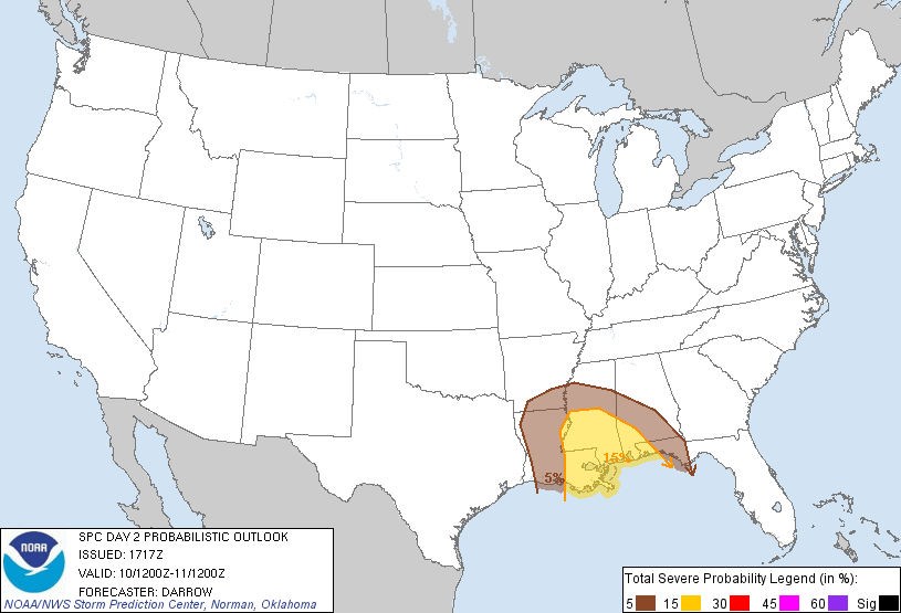
The potential for isolated tornadoes will be higher on Tuesday than today, along with a continued threat for damaging wind gusts and hail around 1 inch diameter as well. Folks living across the Deep South, the Lower Mississippi Valley and adjacent Gulf Coastal areas should remain alert and be prepared to seek shelter if threatening weather approaches or a warning is issued on Tuesday.
By Wednesday, this storm system will have raced Eastward, impacting the Carolinas and southeast coast with similar impacts possible.
If you enjoy reading 'The Original Weather Blog', please be sure to "like" our facebook page and/or follow us on twitter!
No comments:
Post a Comment