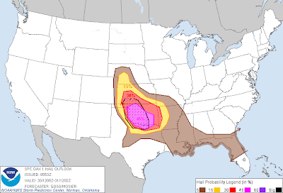
Massive hailstones like the one pictured above (via Fox News in OKC) will be falling again today across much of the same area in Oklahoma. The latest severe weather outlook for this afternoon into tonight from the SPC is shown below:
Severe storms are forecast within the yellow shaded areas on the image, from southwest Nebraska through western and southern Kansas, much of Oklahoma, north Texas and western Arkansas. An enhanced risk of widespread and potent severe weather is forecast within the red shaded area on the same image, which includes much of western Oklahoma and extreme northwest Texas.
The situation is expected to unfold much like yesterday, with thunderstorms initiating near the Western edge of the outlook area during the mid to late afternoon hours and increasing into the evening as the activity moves and/or develops Eastward.
Very large hail of 2 inches in diameter or greater, damaging thunderstorm wind gusts and a few tornadoes can be expected. The highest risk of 2 inch or larger hail and tornadoes lies within the lavender shaded and black hatched area on the image below (which once again includes the Oklahoma City Metropolitan area):
The greatest chance of a tornado will take place with individual storms that are able to remain isolated and become well organized, especially during the first few hours of development late this afternoon into early to mid evening. We didn't really see this type of activity much yesterday, but conditions are a bit more favorable today, so I suspect we'll see isolated to scattered tornadoes within the red shaded risk area.
If you live across this region, please stay alert today. Listen to NOAA Weather Radio or another trusted source for later statements and possible warnings. Be sure to identify your best sheltering option ahead of time, and be prepared to move there quickly if severe weather is observed or a warning issued.
For more information, including "live blogging" during rapidly changing weather events, please be sure to follow me on facebook and/or twitter:


4 comments:
It finally decided to act like May!
Yes, indeed! We nearly had a whole month's worth of hail reports yesterday. It's almost scary to think about what could happen today with stronger dynamics in place in much the same area...
Could shape up to be a significant damaging wind threat if this activity congeals into a strong bow echo. Kind of like what happened in southern Tulsa County last night, but on a much larger scale potentially today...
So is that mostly what we're watching for tonight in Tulsa? A bow echo with possible spin ups, vs an isolated supercell?
Let's not get a month's worth of tornado reports tonight!
Yes, I would agree on that for Tulsa. I think the greatest threat of tornadic supercells will occur late afternoon/early evening in a relatively narrow corridor from southwest/southcentral Kansas into west-central/central Oklahoma.
The activity will then likely congeal into one or more clusters and progress East/Southeastward.
I would expect the greatest threat to your area after 10pm, or certainly late evening, the way it looks right now...
Post a Comment