Unfortunately, our fears of nighttime tornadoes came true on Sunday night / Monday morning, January 23, 2012. Extensive damage was reported during the pre-dawn hours of Monday morning in the Oak Grove, Center Point, Clay and Trussville areas, which are located on the Northeast side of the city of Birmingham, AL.
The image below was created by the National Severe Storms Laboratory in Norman, OK. The red and yellow "swirl" paths indicate where doppler radar estimates that a tornado track took place on Sunday night. The areas circled in red roughly correspond with the actual on-ground damage reports, which the NWS in Birmingham is out surveying at this time.
Of approximately 11 total tornadoes, the National Weather Service (NWS) storm damage survey found 5 tornado paths of EF2 intensity or higher in the general area of Birmingham, as summarized on the map below (please note, this is an approximation only - based on preliminary data):
First I'd like to highlight the series of damage photos below which were taken in the Pilgrims Rest subdivision of Clay, AL. First, note the "hilly" terrain surrounding the damaged (or destroyed) homes. Should put to rest any myth's regarding tornadoes avoiding such an area:
The next photo (from the same subdivision) shows what appears to be most of a home laying in the driveway (at left) after having been lifted off of its foundation (at right):
The next two photos show what appears to be a similar result, with the home having been lifted off of its foundation and dropped adjacent to it (or demolished in the case of the 2nd photo):
These appear to be (once) well constructed homes with brick veneer on at least 3 sides.
Additional photos from the Pilgrims Rest area:
The remainder of the damage photos below are sorted by location (see the notations at the bottom of each photo):
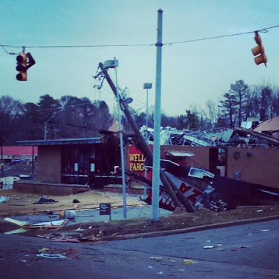
Damage to Commercial Building(s) in Center Point, AL
Wells Fargo Bank in Center Point, AL
Unknown Commercial Damage in Center Point, AL
Residential damage near Clay, AL
Residential Damage in Paradise Valley near Clay, AL
Residential Damage in Paradise Valley near Clay, AL
Home moved off of foundation near Clay, AL
Residential Damage near Toadvine, AL
"Missile" near Trussville, AL
The video below is an unedited version of the damage as captured by the helicopter of the ABC affiliate in Birmingham:
...and from the same crew near Maplesville:
This rather telling "before and after" photo was put together by the AP, and shows what part of one block in Clay looked like before and after the tornado:
Media reports indicate 2 fatalities took place in association with the tornadoes, with an unknown number of injuries (estimated at 100+). The fatalities took place in Clay (a 16 year old girl) and in the Oak Grove community (an 82 year old man).
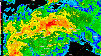
The images below show the NWS radar near Birmingham at 4:03 a.m. CST, as the tornado was impacting the Center Point area. The first image depicts the radar in reflectivity mode (i.e., rain, hail, etc.), and the second depicts the radar in velocity (wind speed and direction) mode. I have placed a small red square on the location of Center Point, very near the center of each image (directly South of Pinson):
Note the "debris ball" on the reflectivity image, and the strong tornado signature on the velocity image. I have circled both in white on the otherwise identical images below:
A debris ball is a signature that is indicated on radar when debris is literally being lifted up and carried along inside of the tornado and/or the parent circulation in the storm. This is always a sure sign of a devastating tornado, and one that we saw repeated numerous times in 2011 (click the image to enlarge):
When looking at the velocity image, keep in mind that the red colors indicate wind that is blowing away from the radar, while the greens indicate wind that is blowing toward the radar. The radar site in this case is located off of the bottom center of the screen. Thus, the couplet indicating strong rotation near Center Point (within the white circle - click image to enlarge):
Another take away from the reflectivity imagery is that this tornado was 100% surrounded by walls of heavy rain. Even if it had taken place in broad daylight, no one in its path would have been able to see it coming.
Needless to say, we need to keep the folks in this region in our thoughts and prayers.
Bookmark this post and check back for updated information, photos, etc. throughout the coming days and weeks. In a situation like this one, valuable information often continues to emerge well after the event...
If you enjoy reading 'The Original Weather Blog', please be sure to "like" our facebook page.
You can also follow us on twitter!


9 comments:
I heard someone say that this tornado (or tornadoes) took almost the same path as the one that tore through in April. Have you checked into that? If so, how devastating for those communities.
Planet Pink,
It appears to be very close indeed.
You can go to this post and scroll down to the map of the Tuscaloosa to Birmingham tornado from 2011. That particular track ended immediately to the Southwest of where we're seeing most of today's damage reports so far:
More on 2011 Birmingham Tornado
Thanks for posting the info and pics. We have friends in Center Point but can't get them...even on their cell phones. Have your news channels shown the path of the tornado yet?
To Anonymous at 11:21am: Unfortunately we don't have firm track information as of yet. Storm damage surveys are being done as we speak. Check back for additional details as they become available.
I certainly hope your friends are okay. Keep in mind that cellphone towers can be damaged far from where they live which could prevent you from getting through even though there isn't a scratch on their house (which I hope is the case).
Also, keep in mind that communications will be jammed with emergency responders, etc., taking the first priority during the early hours of the recovery effort.
Oh dear! Those damage photos surely do bring back bad memories and the track seems to be so close to April's tornadoes! :(
Prayers going out to the families of the teen and elderly man...and to all those caught in the path of this storm!
This is terrible. I stayed up and watched this system blow thru It was a nasty one. I am always so ashamed for being thankful when we don't get hit My heart and prayers go out to the communities and families.
Care to comment on the ef-3 rating that the NWS gave the damage at Clay?
Anonymous at 6:06 PM: That is a "preliminary" rating in Clay. The statement they issued also did not specify exactly what portion of the track they had examined to that point.
I'll reserve comment until the final survey results are in, but I think some of the photos we've posted today speak for themselves...
Storms such as tornadoes ,hurricanes have the strong factor to extensive damage property. Storm damage Birmingham is here to help with storm damage Restoration in unfortunate case of natural disaster.
Post a Comment