A sporadic tornado touchdown took place during the early morning/pre-dawn hours of Wednesday, January 25th in the northeast part of Austin, TX.
The official National Weather Service survey rated this tornado EF-1 intensity. The tornado is estimated to have touched down around 2:58 am CST near the intersection of Old Manor Rd. and Commercial Park Drive:


The official National Weather Service survey rated this tornado EF-1 intensity. The tornado is estimated to have touched down around 2:58 am CST near the intersection of Old Manor Rd. and Commercial Park Drive:

The tornado then traveled in a general Northerly path before ending near Ferguson Lane just Southeast of Sansom Road at approximately 3:05 am CST. This results in a total estimated path length of 1.14 miles. The damage swath was 50 yards wide in some spots along the path
Here's an interactive path map that you can look at on Google Maps or Google Earth. Click on the balloons with points in them to see the corresponding damage photo:
View Austin Tornado Track 1-25-12 in a larger map
I live just South of Austin, so I was able to go up and personally inspect and photograph the damage myself the following day. Based on what I observed, I do not believe that the tornado was necessarily on the ground continuously, but likely "hopped and skipped" along the above path.
The most concentrated and significant damage took place near both the beginning and ending points of the track. There were 3 buildings directly impacted near the beginning point of the tornado. I have labelled their locations as A, B and C on the same track map below:

Building "A" suffered damage to the South (not shown) and West sides, as shown in the photo below:

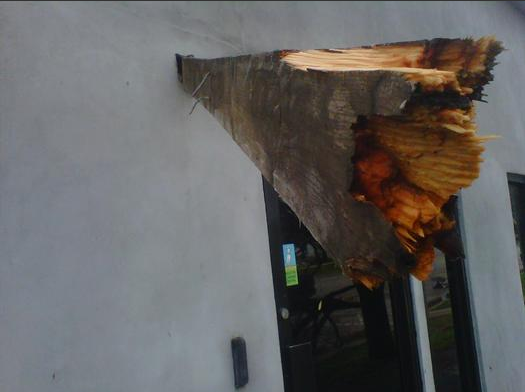
The circulation then continued Northward, striking a destructive blow to the warehouse next door, which is noted as Building "B" on the above map:


A projectile was ejected from building "B" and became embedded in the exterior wall of a stucco-veneer building across the street (noted as building C on the map). Please note, the 2 photos showing the projectile were taken by YNN TV in Austin:


The tornado then continued Northward, skipping along its path breaking windows and lifting rooftop air conditioner units off of a few neighboring buildings. A partially downed wooden fence and a few broken tree limbs were the only evidence of damage as the circulation approached Highway 290 between Springdale Road and Ferguson Cutoff.
After crossing Highway 290, the circulation entered the Walnut Place subdivision, causing fairly widespread (but generally minor) damage to the tops of trees and some wood fences in the Western portion of the subdivision. The fence and tree damage below is shown at point "D" on the track map:

The circulation then apparently intensified once again, removing most of the roof of a home located near Happy Trail and E-K Lane (point "E" on the map):

The circulation then mostly lifted again, taking off the tops of a few trees before diminishing near the intersection of Ferguson Lane and Sansom Road.
It is also noteworthy that the parent thunderstorm continued on to the North or Northeast and produced some significant straight-line wind damage in the vicinity of Crystal Bend Drive and Immanuel Road in Pflugerville, including damage to the Pflugerville ISD Bus Barn:

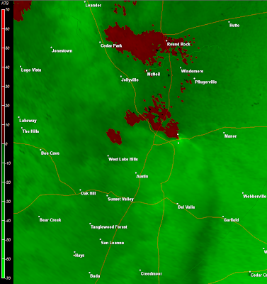
Thunderstorms with heavy rainfall were widespread across the region at the time of the event. The best radar site with a relatively clear view of the storm was the "Central Texas" site, which is located near Granger (which is located approximately 30 miles to the North/Northeast of the damage path).
The series of images below show the radar in base velocity mode (wind speed and direction), for each of 2:56, 3:00, 3:05 and 3:10 am CST, respectively. The two white dots near the center right portion of each image (to the left of the notation of the city of Manor) note the beginning (Southern/bottom dot) point and ending (Northern/top dot) point of the tornado damage:


When examining the wind velocity data, keep in mind that the green colored shadings show wind blowing toward the radar site, while the red colored shadings show wind blowing away from the radar site. The radar site is located just off of the top right corner of each image.
With the above in mind, the only image that depicts any tight rotation (which would suggest a tornado on or near ground level) is the 3:00 am CST (second) image. I have circled that rotational couplet in yellow on a copy of the same image below:

The radar estimates that the peak winds at the center of the rotation couplet were blowing at approximately 86 mph at that time. This was shortly after the damage to the warehouse had taken place, and just before the damage to the roof on Happy Trail likely took place.
The next two images depict a zoom-in on the rotation couplet as shown in the 3:00 am CST image. I have noted the couplet by a yellow circle with white arrows showing the wind direction in the second image:


The circulation unwound rapidly by the 3:05 and especially the 3:10 am CST images, however strong, gusty outflow winds of 50-60 mph are noted, which caused the damage to the bus barn near Pflugerville (annotated 3:10 am CST image is shown below):

The reflectivity (rain, hail, etc.) imagery is not particularly revealing, with widespread, heavy rainfall taking place across much of the region at the same time that the damage took place. The sequence of images below show the same radar in reflectivity mode for the same image times of 2:56, 3:00, 3:05 and 3:10 am CST, respectively:


I suppose you could interpret somewhat of a "comma head", particularly in the last 2 images. When we look at the velocity data at the same time, we could argue that it was a rotating comma head, which can be associated with wind damage and/or tornadoes. I've noted what I'm talking about with a white circle on the following copies of the 3:05 and 3:10 am CST images:


A Tornado Watch (#13) had been issued by the SPC in Norman at 10pm CST on Tuesday evening, about 5 hours before the event took place. The watch was valid until 5am CST Wednesday morning. There were no Severe Thunderstorm or Tornado Warnings in effect when the event took place.
If you enjoy reading 'The Original Weather Blog', please be sure to "like" our facebook page!
4 comments:
Do you agree with the EF-1 rating? That warehouse looks pretty tore up...
Anonymous @ 9:11pm: I believe the damage to the warehouse was very high end EF-1 to very low end EF-2. That damage was extremely isolated. It may have also been a combination of straight line/downburst wind and tornado damage, but was very hard to diagnose because of the very limited area that was affected.
Thanks a bunch for sharing this with all people you actually recognize what you are talking about!Bookmarked. Kindly also discuss with my website.
Spring TX air conditioner service
Awesome Post Storm damage in Texas
Post a Comment