As expected, yesterday was a very active severe weather day, with widespread reports of large hail, damaging winds and a concentrated area of tornadoes in Nebraska, northwest Kansas and parts of Iowa. In total, just over 350 reports have been received thus far, and we'll likely hear of more today as damage is surveyed from activity late yesterday evening & overnight.

See postings here and here for a video and photo of one of the largest Nebraska tornadoes. More photos and videos will be posted later today as they start flowing in.
I am happy to say that, so far, there have been no reports of deaths or serious injuries associated with yesterday's tornadoes and/or damaging winds. I'd like to think that's a testament to the warning process and folks being aware and staying alert in the severe weather threat areas. Hopefully we'll see that again today, (although the threat is not as pronounced as it was yesterday).

Above is the latest severe weather outlook for today from the SPC in Norman, OK. Severe thunderstorms are forecast within the yellow shaded areas on the above image. Large hail & damaging winds will be the primary severe weather threats today, however isolated tornadoes also cannot be ruled out, particularly when storms are within their first few hours of development.
An enhanced threat for damaging winds is forecast within the red shaded areas on the image below:
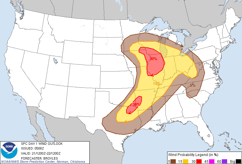
...and an enhanced threat of very large hail (golfball size or greater) is forecast within the red areas on the image below:

A cluster of strong to severe storms continues over northeast Texas and northern Louisiana this morning, with another less intense cluster moving East through the St. Louis area:

Marginal hail and/or wind gusts to severe limits may occur for a few more hours with this activity, and the clusters will also leave behind surface boundaries that could focus redevelopment of thunderstorm activity later this afternoon.
Otherwise, thunderstorms are expected to redevelop by mid to late afternoon along and ahead of a cool front and dryline from the Midwest into the central and southern Plains (near the Western edges of the severe weather outlook area from the 2nd image). Outflow boundaries from the morning thunderstorm complexes may also focus redevelopment near and/or East-Southeast of where they diminish later this afternoon.
Large hail and damaging winds will be the primary severe threats today, however isolated tornadoes are also possible with any more isolated storms that are able to organize prior to merging into a larger complex or cluster of activity.
At this time, it appears that storms within the red shaded areas on the 3rd and 4th images are likely to become the most organized today, with locally enchanced potential for damaging winds, large hail & isolated tornadoes. This would include portions of far eastern Iowa, southern Wisconsin, much of central & northern Illinois and extreme east-central & northeastern Missouri. Another band of locally enhanced severe potential appears to be setting up across southwest Arkansas, southeast Oklahoma and northeast Texas.
If you live across or near any of the severe weather outlook areas for today, please remain alert and be prepared to seek shelter if threatening weather approaches your area.
15 comments:
Hey Rob...I just had to tell you the irony of my decision yesterday. Or, actually, what WOULD have been very ironic!
Because I travel with a 3 year old and a teen (my kids), the thought of driving 5 hours (approximately) didn't sound too appealing to go to Columbia, MO. Instead I drove to Eastern Iowa (not far from Iowa City) and took my chances that the storms would be more wind/hail by the time they got to us.
I looked at the damage reports today only to find that there was a report from Columbia!! Where I was, we got less than a tenth of an inch of light rain. Husband said it rained at home, but nothing major.
One of these days I'll learn to just stay home and avoid spending the money to "run"!
Thanks again for all you do! I love this blog!
So glad you and your family are ok, Anthill!!
Rob, once again we are under a slight risk for severe today-15% for damaging winds. I am watching these storms quite a ways west of us go N/NE and some are getting real close to us on the East of us in North Carolina-and some North of us in Virginia and Kentucky also pulsing severe. Nothing is hitting us-and I am not complaining but why is this? This happens A LOT!! They head right for us and veer at the last moment or they weaken. Is it luck? I am a little concerned though-I am looking at all the stuff going on in Alabama and Mississippi right now-is this going to weaken too with loss of daytime heating? Thanks :)
Thanks, Shamrock!
I'm by no means an expert on weather patterns, but I have gotten pretty good at looking at what's going on and giving a guess! LOL
Their will be a new SPC forecast coming out in about 2 hours but the latest one says "EXPECT MULTICELL CLUSTERS TO PERSIST WITH A RISK OF AT LEAST ISOLATED DAMAGING DOWNBURSTS...AND MARGINALLY SEVERE HAIL." My GUESS is that they're linked to day-time heating and will start to wane afte sunset...but Rob would know much better!
As far as it happening often that they split around you? My step-father SWEARS that he lives in a "dry slot" and that, although they get storms, a good portion of the time they miss him one way or the other. Not sure if there IS such a thing, but he sure believes it!
Hope the winds that are possible miss y'all this evening!
Anthill Goddess, Thanks for the comment. Glad to hear you made out okay. Yes, just as expected, strong winds moved as far East as Columbia overnight, as the tornado potential had diminished.
Didn't you tell me that you have a tornado shelter or safe room at home one time? If not, you might want to consider one before next spring. Maybe then you'll find more "comfort" near home and not have to take off again!
Thanks, Anthill!!! I am hoping they're linked to daytime heating. It's 90 degrees here today! The people here believe that storms break on our mountain....I must admit that it seems that way much of the time. We also live in a valley up here and are surrounded by trees so that helps break up wind as well...at least I think it does. I think you are right with your forecast for us, though. Now all we need is Rob to get in here and give his wise ol' 2 cents :)
Shamrock / Anthill Goddess, sorry for the delayed reply, I've been unavailable to update the blog (or even look at the weather) all day until just now...
Shamrock, you'll want to monitor the activity that is currently over middle Tennessee. Damaging wind gusts will be the primary threat, particularly if any of the storms were to start moving more rapidly toward the East with small "bows" within the radar signature.
Thus far, the activity is what we call "multi-cellular", meaning strong to marginally severe thunderstorms are clustering together and competing for energy. This tends to decrease the overall severe threat, however strong, gusty winds are still possible. I wouldn't be concerned about a significant tornado threat with this type of activity.
Rob, sadly, yes, I have a basement (bows head in shame for still being scared) LOL
It's wide-open, though, with no separated rooms at all...something that I think my husband and I will be working on this fall/winter. We will be enclosing the underside of our stairwell in the basement to make an area where we could be more safe from falling/flying debris and then my husband is under instruction to make me stay at home and "just deal with it". I told him I'd rather we just bury the entire house. ;-)
Anthill you're so funny!I LOL'd at your "bury the entire house" comment!
Rob, are these multicell clusters going to weaken when the sun goes down?
Anthill_Goddess, nothing to be ashamed of at all. After I went to Joplin and saw basements filled with debris, I certainly understand your point of view. Sam, one of the gentleman I had the pleasure of meeting in Joplin, survived in his basement only because he had a tornado saferoom in the corner. If it had not been for that, he would have been crushed by debris most likely.
I highly recommend a tornado saferoom in any basement. If you and your husband are "handy" at all, you could build a saferoom in the corner of your basement using masonry block and some sort of steel reinforcement between the masonry and a steel reinforced plate on the ceiling. The point is to put as much strength between you and potential debris as possible. You can find simple plans online by a quick google search, if you don't want to pay a contractor to do it.
The lawyers (not that I have any, but you know...) would want me to add that you should check and make sure that you don't need a building permit to make any such adjustments to your home in your locality...
Shamrock, multicell activity is highly dependent on daytime heating, so yes they will probably weaken some after dark.
There is some pretty strong activity moving ever closer to you from the West right now. Keep an eye to the sky over the next hour or two! Wind gusts to 60 mph and 1 inch hail possible...
Rob-Yeah, there is a cluster of a few storms to the West of us right now. I am looking at radar and it looks like they're gonna go JUST over us. They'll get close, though. It just got good and dark here and the storms on radar are breaking up and weakening a bunch already. That little cluster of red to the West is still severe, though....and I just looked again before sending this comment and I'm fairly confident it's gonna just miss us. Which brings me to another question I have been meaning to ask. On NEXRAD radar they id the storms. A-Z with numbers. For instance the severe storms to the West of me are X8 and M9-how do they determine which letters and numbers to apply to a storm?
Rob-So, I shut down my computer thinking everything had passed us. I started hearing thunder-looked out my window in time to hear a tree snap and fall on our neighbor's carport. A VERY strong/severe thunderstorm just blew thru here. I was scared to death. The wind was howling!!! I turned on my computer to see we were under a STW and clicked on the radar to see a new storm had formed and was right on top of us. This was the nastiest storm-other than the tornado-I have EVER been thru! Everyone is ok. Only damage was the snapped tree at neighbor's. Oh my gosh, though...so scary!
Shamrock, the identifiers assigned to thunderstorms on the NEXRAD system are part of the "storm attributes" portion of the software package. The computer randomly assigns a letter and number to storms. The more storms there are out there, the deeper into the alphabet and higher numerically the system will have to go.
Storms are labelled so that you can refer to a specific "attribute" (i.e., hail, circulation signatures, tracks, etc.) of the storm on a window that looks like a table of contents in most radar software packages.
I don't post the Storm Attributes Table very often... but here is a link to one from back in April: http://originalweatherblog.blogspot.com/2011/04/update-on-severe-weather-along-oklahoma.html
Thanks for the info, Rob! I've learned a lot from you this year. I found you via a twitter feed during the tornado outbreaks in April 2011-so glad I did. Sometimes I can't find what I am looking for via google, such as with the NEXRAD storm ids. You also explain weather in a way that dummies like me can understand. I also am quite fond of you and a few others who blog here such as Anthill and Planet Pink!
Post a Comment