
Rain continues to mix with and change to snow from West to East across the region at midday, as shown on the latest radar mosaic above.
Surface low pressure is getting wound up offshore of the Mid-Atlantic Coast, as shown on the latest composite surface analysis and visible satellite image below:


GFS Forecast Valid 2pm EDT Saturday

GFS Forecast Valid 5pm EDT Saturday

GFS Forecast Valid 8pm EDT Saturday

GFS Forecast Valid 11pm EDT Saturday
Precipitation is currently falling in the form of rain in the major cities from Baltimore/Washington on northeastward along the Coast. Snow is starting to mix in just to the West of the Baltimore/Washington area, and is also beginning to mix in the NYC area. Based on current trends, I expect rain to mix with and change to snow in the Philadelphia area by mid-afternoon and in the Hartford area by late afternoon. I expect rain to change to snow in the Providence and Boston areas tonight or early Sunday morning.
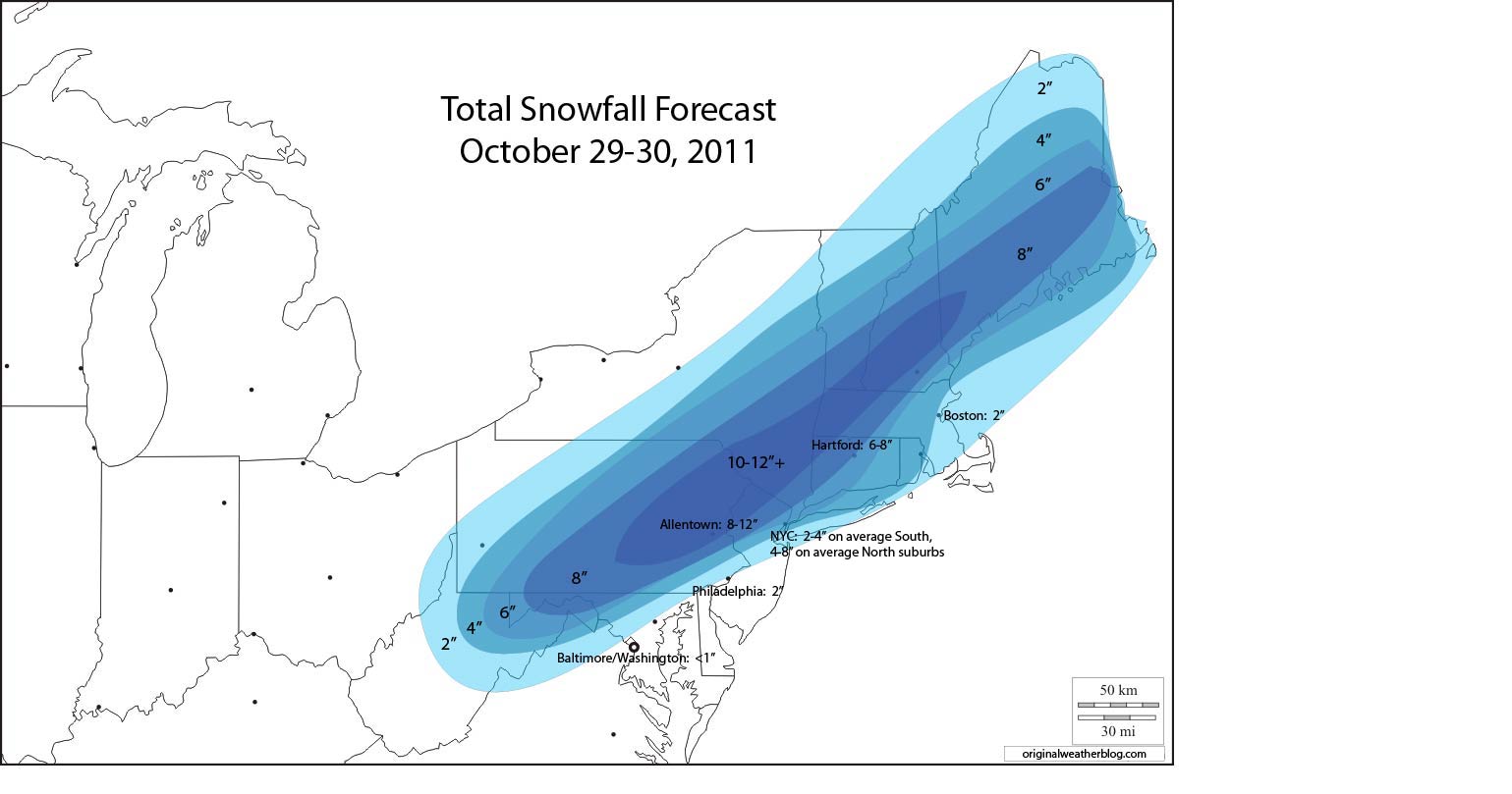
Now...on to the record books. The record October snowfall is 2.2 inches at Washington and 2.5 inches at Baltimore (both set in 1925). It will be tougher to break those records (based on current forecast trends) than it will be at points to the Northeast, but it still cannot be completely ruled out. I currently expect 1-2 inches in Western suburbs, and 1 inch or less in the Baltimore/Washington area itself.
The records that appear to be easily breakable later today and/or tonight include:
New York City (Central Park) - 0.8 inches in 1925
Hartford - 1.7 inches in 1979
Boston - 1.1 inches in 2005
It's going to be a close one in Philadelphia. The record at the airport is 2.2 inches set back in 1925 (the same storm that set the NYC and Baltimore/Washington area records). I currently have the 2 inch line drawn right through Philadelphia on my forecast, which is shown in the image below:

The image below is the same, but with some of the major city point forecasts included:
As mentioned in posts throughout the week, this will be a heavy, wet snow, with significant potential for widespread tree and powerline stress and/or damage in areas with more than 2 inches of accumulation. The wind will further aggravate this threat.
As shown on the GFS model forecast images above, North to Northeast winds of 20-30 mph with gusts to 50 mph will become widespread across central and northern portions of the forecast area by this evening. The winds will be strongest from just Northeast of Philadelphia, on Northeastward across the region. The high wind threat includes the NYC Metro area, Hartford, Providence, Boston, and interior areas to the West of that line.
Combine the heavy, wet snow with the high winds and a significant threat for power outages will exist across much of the region.
Now that the event is getting underway, future updates will focus on photos and/or videos on the ongoing event, as well as any short-range changes in the snowfall forecast, if needed. This particular post will not be updated, so please check the blog homepage or the "10 Most Recent Posts" link at the right hand side of the page for future updates...
***Update to add picture regarding Comment by Larry Wirth. This image was just posted on twitter by a viewer of the Yale/Columbia game:

If you enjoy reading 'The Original Weather Blog', please be sure to "like" our facebook page!
2 comments:
I'm watching the Yale @ Columbia football game (on TV) - 2 inches of snow on the field at Wein Stadium (N end of Manhattan). It's halftime and they are plowing the field for the 2nd half!
Thanks for the comment/report Larry. I posted a pic from twitter of what you're describing...
Post a Comment