Thursday, June 30, 2011

Tropical Storm Arlene Making Landfall in Mexico


At 7am CDT, the center of Tropical Storm Arlene was located along the Mexican coast near Cabo Rojo.  Maximum sustained winds were estimated at 65 mph, and the minimum central pressure was 29.32 inches of mercury.


Arlene is moving West at 8 mph, and will continue on this general motion as she progresses into Mexico today and tonight.  Very heavy rains and strong, gusty winds can be expected well inland across Mexico through Friday:


Bands of rain and thunderstorms, some heavy, continue to stream along the Northern edge of Arlene into the Brownsville, McAllen and adjacent portions of  Deep South Texas this morning:


This trend will continue today, with up to 2 inches of rain possible in heavier showers.   The heaviest rains, which will exceed 6 inches in some areas, will take place South of the border into Mexico:


If you enjoy reading 'The Original Weather Blog', please be sure to "like" our facebook page!


Wednesday, June 29, 2011

Arlene's Winds up to 60 MPH...


At 5pm CDT...a Hurricane Hunter aircraft measured sustained near-surface winds of 60 mph in association with Tropical Storm Arlene.  The center of the system was located about 120 miles East of Tuxpan, Mexico, and moving West at 7 mph.  Minimum central pressure was measured at 29.41 inches of mercury.

The Government of Mexico has issued a Hurricane Warning from Barra De Nautla to La Cruz.  This replaces the Tropical Storm Warning and Hurricane Watch that was previously in effect.

The latest radar image from the Alvarado, Mexico radar is below, and gives us a nice look at the southern-most precipitation bands associated with Arlene:


During the afternoon, bands of thunderstorms and showers have clipped the extreme southern tip of Texas, near the Brownsville area, in association with the northern-most extent of Arlene.  According to the latest Brownsville radar image (below), additional showers and thunderstorms will continue to brush far South Texas later this evening & into tonight as Arlene begins to make landfall well to the South in Mexico:


The official National Hurricane Center forecast (below) continues to keep Arlene below Hurricane force through landfall, but there is still a chance that the system could arrive along the central Mexican coast as a minimal hurricane on Thursday morning.


If you enjoy reading 'The Original Weather Blog', please be sure to "like" our facebook page!

Tropical Storm Arlene Continues Toward Mexico...


At 10am CDT, the center of Tropical Storm Arlene was located about 155 miles East/Southeast of Tampico, Mexico, and moving West at about 8 mph.  Maxiumum sustained winds are estimated at 50 mph, and the minimum central pressure was 29.53 inches of mercury.

Some additional strengthening is forecast as Arlene continues on a general Westward path over the next 24 hours.  The following forecast track from the NHC still shows Arlene remaining at Tropical Storm force through landfall, however she may reach minimal hurricane force prior to making landfall:


The government of Mexico has issued a Hurricane Watch from Tuxpan to La Cruz.  A Tropical Storm Warning remains in effect from Barra De Nautla to Bahia Algodones.

Very heavy rain, strong, gusty wind and dangerous surf can be expected along the central Mexican coast through tomororw.


If you enjoy reading 'The Original Weather Blog', please be sure to "like" our facebook page!

Tuesday, June 28, 2011

Invest 95 Declared "Arlene" - First Tropical Storm of Atlantic Season


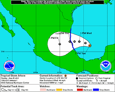
Tropical Storm Arlene has formed in the extreme southern Gulf of Mexico.  At 7pm CDT, the center of Arlene was located 280 miles East/Southeast of Tampico, Mexico, and was moving West/Northwest at 7 mph.  Maximum sustained winds were estimated at 40 mph.


The official NHC forecast track is shown below.  At this time, Arlene is not expected to reach hurricane strength before making landfall along the Mexican coast on Thursday afternoon:


See this recent post for additional information.


Like this blog?  Please "like" our facebook page!

'Invest 95' About to Become a Depression... or 'Arlene'...


An Air Force Hurricane Hunter aircraft investigated the area of disturbed weather (dubbed "Invest 95") in the Bay of Campeche this afternoon.  While they did find a closed circulation (an area of low pressure), they did not find a core of sustained winds strong enough to classify the system as a Depression.    This is likely due to the fact that middle & upper level winds are still causing some shear over the system, preventing it from fully organizing.  That condition, however, is expected to change over the next 12 hours, which will allow the system to undergo some fairly rapid organization.

Below is the latest image from the nearby Alvarado, Mexico radar:


You can see some of the outer feeder bands of precipitation beginning to flow Westward into the radar's view.  The center of the system is off to the right (or East) of the image.

The system continues to maintain a slow West/Northwestward drift, and this motion is expected to continue for the next few days.  Below is the latest computer model forecast track of the system over the next 3-5 days, which continues this same general motion:


It is quite likely that the system will become at least a depression during the next 12-24 hours.  If surface winds become sustained at 39 mph or higher, we could jump right into Tropical Storm Arlene - which would be the first named storm of the 2011 Atlantic Season.

Regardless of the eventual classification of the system, very heavy rains and gusty winds will continue to be produced across portions of Central America and the Mexican coast (particularly the Mexican states of Tamaulipas and Veracruz) over the next few days.


Tropical "Invest 95L" Slowly Organizing...

In a post yesterday evening, I commented on a tropical disturbance that had flared up over parts of Central America & southeast Mexico.  


As of midday today the system continues to slowly try to get organized (as noted by the white circled area on the above satellite image).  It continues to drift very slowly toward the West/Northwest.

The National Hurricane Center (NHC) plans to send a "Hurricane Hunter" aircraft into this system later this afternoon to investigate and see if the system has developed any organized circulation or low pressure center.

Computer forecast models continue to develop the system over the next few days, and keep it on a general West/Northwestward track:


We'll provide more updated information later today as data flows in from the NHC aircraft.


Midday Severe Weather Update


A complex of severe thunderstorms continues to advance South/Southeastward across portions of the Mississippi Valley and the Deep South at midday.  Damaging winds and large hail are likely with both of the bowing segments that you can see on the above radar image.

Severe Thunderstorm Watches have been issued along and South of this activity into the afternoon hours.  The latest watch includes a part of far northeast Texas, and it is certainly possible that the band over Arkansas will continue to develop back Westward far enough to impact part of northeast Texas later this afternoon.

For additional details on the remainder of the severe weather threat for this afternoon & evening, please see my earlier post.

Severe Weather Outlook for Today, Tuesday, June 28, 2011


Above is the latest severe weather outlook for today from the SPC in Norman, OK.  Severe thunderstorms are possible anywhere within the yellow shaded areas on the above image.

Severe Thunderstorm Watches are currently in effect across portions of the Deep South, as a complex of severe thunderstorms with damaging winds continues to move Southeastward this morning:


An enhanced risk of damaging winds will continue along and ahead of this activity today, as indicated by the red shaded areas on the image below:


Additional clusters of severe storms are expected to form this afternoon & evening across portions of the mid-Atlantic and Deep South.  Several boundaries being produced by the current complex moving across Arkansas, Mississippi and Alabama will also focus additional development during the heat of the day, particularly to the South of the location of the current thunderstorm complex.  Damaging winds & large hail will be the primary severe weather threat across this region today, although an isolated tornado cannot be ruled out.  This would particularly be the case with any thunderstorm that is able to remain rather isolated and become well organized.

Further West, scattered severe storms are forecast by mid to late afternoon across portions of east-central & northeast Colorado.  Large hail and damaging wind gusts are the primary threat with this activity, however isolated tornadoes are also possible during the first few hours of initiation.  This activity is likely to congeal into one or more clusters or a small complex and move East/Southeast into adjacent portions of western Kansas this evening, and perhaps as far as the Oklahoma panhandle or northwest Oklahoma region tonight.  Damaging winds would be the primary threat by that time.

Monday, June 27, 2011

Tropics Flaring Up?


The above satellite image was taken just a moment ago.  The red circled region on the image denotes a tropical disturbance over the Eastern part of the Bay of Campeche.  This system is currently dubbed "Invest 95L".  (For more information on the various stages of tropical system classification, see a recent post here).  It is drifting very slowly toward the West/ Northwest - a motion that is expected to continue for the next few days.

A "Hurricane Hunter" aircraft is scheduled to visit this disturbance tomorrow if it continues to slowly organize overnight.  Right now, middle & upper-level conditions are not favorable for rapid development, however that will change over the next few days, with more favorable conditions for development possible by Wednesday.

Very heavy rains and gusty winds will continue across portions of southeastern Mexico and much of Central America for the next few days as this system drifts slowly West/Northwestward.

Computer forecast models are currently keeping the system on a general West/ Northwestward track for the next 5-7 days, as shown on the latest composite computer model forecast image below:


Keep in mind that errors in the computer models can be quite large beyond the 2-3 day timeframe with this type of developing/infancy stage system, so take the above image "for what it's worth..."

Severe Weather Outlook for Today, Monday, June 27, 2011


Above is the latest severe weather outlook for today from the SPC in Norman, OK.  Severe thunderstorms are possible within the yellow shaded areas on the image.  Within the overall severe weather threat area depicted above, there is an elevated risk of damaging winds and large hail, generally within the red shaded areas on the image below:


A complex of strong to severe thunderstorms, which originated yesterday evening over Iowa & northern Missouri, is currently moving Southeast across southeast Missouri and southern Illinois.  The complex has weakened slightly over the past 1-2 hours, however locally strong, gusty winds will continue to be a threat along and ahead of this complex this morning.

This complex will leave behind several surface boundaries that will focus severe thunderstorm redevelopment later this afternoon across portions of the mid-Mississippi and Tennessee Valley areas.  Large hail, damaging winds and isolated tornadoes will be possible with this activity.

Otherwise, several clusters of severe thunderstorms are forecast to develop this afternoon & evening across portions of the Midwest, Great Lakes and into the western Ohio Valley.  Large hail & damaging winds will be the greatest threat with this activity, although isolated tornadoes also cannot be ruled out, particularly with any storm that is able to remain rather isolated and become well organized.

Just like yesterday, activity that forms this afternoon & evening is likely to congeal into one or more thunderstorm complexes that will roll to the East/Southeast overnight tonight.  Damaging winds would be the primary threat by that time.

A smaller area of severe thunderstorm development (geographically speaking) is forecast to take place over portions of southeast Colorado, northeast New Mexico and into the Texas/Oklahoma panhandle region this afternoon & evening.  Large hail and damaging winds will be the primary hazards in this area, although isolated tornado development is also possible.

If you live in or near any of the above areas, please remain alert this afternoon & evening and be prepared to seek shelter if threatening weather approaches your area.  Take the time now to review severe weather preparedness tips, and have a plan in place to take action on short notice if necessary.

Sunday, June 26, 2011

Severe Weather Update - Iowa / NE Kansas / NW Missouri


A bowing complex of severe thunderstorms with a history of 65-75 mph winds and tennis ball sized hail continues to move East/Southeast at nearly 65 mph this hour.  At this rate, severe thunderstorms with damaging winds can be expected in the Des Moines area before 10pm CDT.

This complex will also clip the extreme Northeast corner of Kansas as it moves into northern Missouri during the next couple of hours.  Portions of southcentral & southeast Iowa will also be affected.

Damaging winds in excess of 65 mph and large hail are likely with this activity.

If you live in the path of this activity, seek immediate shelter indoors and stay away from windows until threatening weather passes your area.

Severe Weather Update - Central Plains


The above radar mosaic shows an intense cluster of severe storms continuing to advance toward the Southeast across eastern Nebraska at this hour.   Damaging straight-line wind gusts of 70-80 mph and hail up to golfball size are possible with this activity.  Below is a closer view of this thunderstorm complex as shown by the Omaha area radar:  


This complex of thunderstorms will continue advancing Southeastward this evening, likely impacting the Omaha area between 8 and 9pm CDT.  Damaging winds and large hail will continue to be the primary threat with this particular activity.  Any isolated thunderstorm that manages to form out ahead of this complex over southeast Nebraska or southwestern Iowa would also have a chance of producing a tornado.  Please remain alert to this possibility until the larger thunderstorm complex clears the area.

Severe Thunderstorm (blue) and Tornado (red) watches are in effect across the region this evening and into tonight, as shown on the image below:


Additional severe thunderstorm activity is expected to develop across Missouri (within the Tornado Watch area) this evening, some of which could produce tornadoes.  Large hail & damaging winds can also be expected in these areas.  In addition, the complex of storms currently approaching the Nebraska/Iowa border area is likely to track Southeast into northern Missouri later this evening.  If the complex back-builds toward the Southwest, then portions of northeast Kansas could also be affected later this evening.

Another Scorcher in the Lone Star State...


Above is a map depicting weather conditions at 4:20 pm CDT.  I have circled the highest 3 temperature readings in Texas, which were:

117 degrees in Childress
113 degrees in Perryton
111 degrees at both Lubbock and Wink

The all time record high temperature in Texas was 120 degrees recorded in Seymour on August 12, 1936 (where it's 107 degrees right now, by the way).

Could Childress take out Seymour's record today?  It's certainly possible...

Severe Weather Update - Nebraska & Western Iowa


Thunderstorms have been attempting to develop and organize for the last couple of hours in a band from southeast Nebraska into southwest Iowa, as shown in the above image just taken from the Omaha area radar.

So far, this activity is developing just above the surface level, ahead of a warm front that is slowly lifting Northward out of Kansas.  During the next couple of hours, this activity is expected to become better organized and rapidly intensify as very warm, unstable air lifts Northward into the region from Kansas on the approaching warm front.

Very large hail, damaging winds and a few tornadoes will be possible with stronger storms that form within this region.  I would expect a Tornado Watch to be issued during the next 1-2 hours for this area.

Meanwhile, strong to severe thunderstorms continue to organize further to the Northwest over Nebraska, as shown in the latest North Platte area radar below:


A Severe Thunderstorm Watch is currently in effect for this region until 8pm CDT:


This activity is likely to continue moving and/or developing Southeastward during the evening hours, and could pose a significant risk of damaging winds and/or hail into southeast Nebraska and adjacent portions of western Iowa later this evening (in addition to the other severe weather threat described for that same area at the beginning of this post).

Depending on the exact eventual movement of this complex, it could also affect portions of far northeast Kansas and northwest Missouri later this evening as well.

If you live across any of the above mentioned areas, please remain alert this evening.  Review severe weather preparedness tips, and be prepared to seek immediate shelter if threatening weather approaches your area.

Severe Weather Outlook for Today, Sunday, June 26, 2011


Above is the latest severe weather outlook for today from the SPC in Norman, OK.  Severe storms are possible later today and/or tonight in a broad swath extending from the northern High Plains, Southeastward into the Mississippi and Tennessee Valleys.  Severe storms are possible anywhere within the yellow shaded areas on the image above.  An enhanced risk of severe thunderstorms, including one or more possibly strong tornadoes, is forecast within the red shaded areas on the same image.

A couple of clusters and/or complexes of strong thunderstorms continue to advance East/Southeast across portions of the Mississippi and Tennessee Valleys this morning, as indicated on the radar mosaic image below:


This activity will continue to slowly weaken as it progresses Southeastward this morning.  Gusty winds and some marginally severe hail are possible with a few of the stronger storms.  This activity will likely leave behind several surface boundaries that may focus severe thunderstorm development again late this afternoon or this evening, especially immediately along and to the Southeast of the locations where this present activity diminishes later this morning.

Elsewhere... thunderstorms are forecast to develop rather rapidly by mid to late afternoon across portions of the northern & central High Plains.  In particular, the area from central and eastern Nebraska into western Iowa appears to favor organized thunderstorm development by mid to late afternoon.  The combination of a strong upper-level weather disturbance and a warm front focusing lift and instability at the surface will result in many of these storms becoming severe.  Very large hail, damaging winds and tornadoes will all be possible with this activity.  One or two of the most organized storms may also produce a strong tornado in this region.  The area with the highest risk of significant tornado development lies within the red and black hatched area on the image below:


Once formed, this activity will move and/or develop generally toward the Southeast, with portions of extreme northeast Kansas and northwest Missouri potentially seeing some of this activity move in from the Northwest by this evening.

Very large hail (i.e., greater than 2 inches in diameter), is forecast with severe storms that form within the red & black hatched areas on the image below:


and the threat for damaging winds is highest within the red shaded areas on the following image:


Thunderstorm activity that forms in the northern and central Plains this afternoon & evening is likely to organize into one or more complexes of thunderstorms that will move Southeastward into portions of the Midwest, Tennessee and Mississippi Valleys overnight.  Damaging winds would be the greatest severe weather threat in association with the activity by that time.

There is also a chance for isolated severe thunderstorm development along a dryline extending from southwest or southcentral Kansas into portions of western Oklahoma and extreme northwest Texas late this afternoon or this evening.  A strong capping inversion is in place across this region, which will generally prohibit thunderstorm development today.  However any isolated thunderstorm that is able to form during the peak heating hours of the day would become severe rapidly, with large hail, damaging winds and an isolated tornado possible.

If you live in or near any of the above described areas, please remain alert this afternoon & evening and be prepared to seek shelter if threatening weather approaches your area.

Saturday, June 25, 2011

Severe Weather Outlook for this Weekend...

Severe thunderstorms are possible this weekend in a swath generally extending from the northcentral High Plains, Southeastward across Nebraska, parts of Iowa and much of Missouri, into the western Tennessee and mid-Mississippi Valley areas.  

Specifically, here is the outlook for today, Saturday, from the SPC:


...and for tomorrow, Sunday:


Severe thunderstorms are possible anywhere within the yellow shaded areas on the above images.

Damaging winds & large hail will be the primary threats, however isolated tornadoes also cannot be ruled out, particularly during the first couple of hours that storms initially develop, when they are isolated to scattered in coverage.  One or more complexes of thunderstorms are likely to form both Saturday Night and Sunday Night (from smaller scale activity that develops each afternoon & evening) and move East/ Southeastward during the overnight hours.  Damaging straight-line winds would be the greatest threat from that portion of the activity.

Thursday, June 23, 2011

Severe Weather Outlook for Today, Thursday, June 23, 2011


Above is the latest severe weather outlook for today from the SPC in Norman, OK.  Severe thunderstorms are possible anywhere within the yellow shaded areas on the above image.

Several clusters of strong to severe thunderstorms are forecast to develop in the above areas this afternoon & evening.  Strong, possibly damaging winds and hail would be the primary threats, although isolated tornadoes cannot be ruled out, particularly with any isolated storm that is able to become well organized in the first hour or two of development.

At this point it is difficult to pinpoint any one specific area that has a higher risk of any particular type of severe weather this afternoon & evening, so please remain alert if you live in any of these areas, and listen for later statements & possible warnings.

That portion of the risk area from southern Kansas into northern Oklahoma and adjacent portions of Missouri and Arkansas is really meant for the late evening and/or overnight hours tonight.  One or more clusters of strong to severe storms are forecast to develop near the Kansas/Oklahoma border after sunset and move and/or develop toward the Southeast overnight.  If this activity is able to become organized, damaging winds would be the most likely threat.

Wednesday, June 22, 2011

Amazing Images from Nebraska on 6-20-11

These pictures literally speak a thousand (or more) words.  Awesome job by www.extremeinstability.com (as posted on Twitter):


If anyone in southwest or southcentral Nebraska reported a UFO on Monday, I couldn't really argue with them based on many of the photos above....  Talk about a flying saucer!


Severe Weather Outlook for Today, Wednesday, June 22, 2011

***Updated 12:50 PM CDT to add graphic:


Unfortunately, Google has still not fixed the Blogger system where we can post any images, but to summarize,  severe thunderstorms will be possible this afternoon & evening across a wide swath extending from the eastern Great Lakes and Ohio Valley, into the Tennessee Valley and portions of the Deep South.  For a graphical representation of the outlook from the SPC, go here.


As soon as Blogger is fixed I will update this post with more graphics showing the threat areas.  It is hard, at this time, to pinpoint a specific location within the overall outlook area that has a higher risk of severe weather than any other today. There may be locally enhanced potential for particularly damaging winds across an area from southeast Michigan into Ohio and northeast Indiana, where a band of stronger winds just above the surface level is expected to set-up.  Thunderstorms that form in this region may develop into one or more organized complexes and continue Eastward into adjacent portions of Pennsylvania and New York later this evening.

Very Thankful for Texas Rains!

We received a whopping 2.65 inches of rain at my home near Kyle, TX overnight!  Awesome!  Even better, from what I can glean by the radar estimation of overnight rainfall, 2-3 inch amounts were widespread along the I-35 corridor and extending well into southeast Texas at this time.

As soon as the problems with Blogger are fixed (see my last post below), I'll upload a few images with rainfall estimates.

Blogger Problems - AGAIN

Trying to make a few posts this morning and can't upload any pictures.  I've tried on several different browsers and two different computers and am getting the same result, so I can only conclude that it is a problem with the Blogger system, and not me.

Will try again later this morning...

Tuesday, June 21, 2011

Severe Weather Update - Austin/San Antonio Corridor


Several clusters and bands of strong thunderstorms continue to advance Southeastward toward the I-35 Corridor at this hour.  Above is the latest image taken from the New Braunfels, TX radar.

Based on present movement of this activity, thunderstorms will overspread the Austin-San Antonio corridor along I-35 between Midnight and 1:30 AM CDT.  Very heavy downpours, gusty winds to 50 mph and hail up to quarter size will be possible with the strongest storms.

Once activity enters a given locality, it will take about one hour to one and a half hours for the storms to pass through.  I am hopeful that most areas will receive at least one-half inch of rain, with localized amounts of 1.5 inches possible.

Severe Weather Update - DFW Metroplex Region


The above image was just taken from the Terminal Doppler Weather Radar just Southeast of Coppell, TX, to the Northwest of Dallas.  A cluster of strong to severe thunderstorms is moving East across Northern sections of Ft. Worth, toward the Northwest sections of Dallas.  The thin blue line that you see in advance of the thunderstorms is a band of strong outflow winds blowing West to East out of the thunderstorm complex.  Radar is currently estimated gusts of 60-70 mph with this activity.


During the next 15-30 minutes, very strong wind gusts of 60-70 mph will be possible from Ponder to Denton, Corinth and Argyle, Southward through Lewisville, Grapevine, Keller, Colleyville and North Richland Hills.    If this activity holds together, the threat will soon extend Eastward into much of central and northern Dallas County.

Hail up to 1 inch in diameter is also possible with this activity.

If you live along or ahead of this activity, seek immediate shelter until threatening weather passes your area.