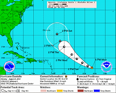
The above image of Danielle was taken about 45 minutes ago. As of the 4pm Advisory, the National Hurricane Center has increased Danielle to Hurricane strength, with sustained winds of 75 mph. The center of the system was located 1320 miles East of the Lesser Antilles...and was moving West/Northwest at 17 mph.
The latest forecast track continues to hold Danielle out to sea, with no major land masses currently forecast to be affected through Saturday.
If a trough of low pressure develops across the Eastern U.S. as forecast later this week, then Danielle would be steered to the East of Bermuda over the coming weekend. If the trough is not as strong as currently forecast, or moves out faster than currently forecast, then the track could be further Westward toward Bermuda. This will be something to watch as the week unfolds.


No comments:
Post a Comment