**Update 4-24-11, 8:30 am CDT:
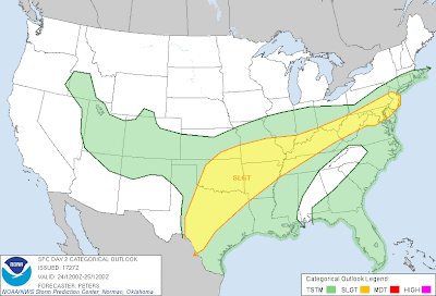
Little change to the thinking from yesterday's original post. Severe thunderstorms are possible this Easter Sunday within the area outlined in yellow in the image below:
This obviously covers a broad swath of the country, literally from the Mexico border in Texas to the Atlantic Coast off the Northeast. Within that broad area, an enhanced risk for severe storms with very large hail will exist in the red and black hatched areas on the image below:
This enhanced risk of large to very large hail includes the Dallas/Ft. Worth Metroplex, Abilene, San Angelo, McAlester, Ft. Smith and Paducah.
Isolated tornadoes will be possible with most any storm that forms today, however the best chance of tornado development appears to exist from northcentral Texas through southeast Oklahoma and into northwest Arkansas and the Missouri bootheel.
Residents across all of the severe weather outlook areas should remain alert and listen for the latest weather information. Be prepared to seek shelter if threatening weather moves into your area.
The best chance of severe weather will occur from mid-afternoon into this evening. Strong thunderstorms are already underway across portions of east-central Oklahoma, heading toward northwest Arkansas this morning. Some of this activity could produce hail to severe limits this morning. Stronger re-development of thunderstorms is expected this afternoon & evening, so please don't think that the threat of severe weather is over once this initial round of thunderstorm activity passes.
------------------------------Original post from 4-23-11:
Above is the latest severe weather outlook for Easter Sunday, 2011, from the SPC in Norman, OK. Severe weather is possible anywhere within the yellow shaded region.
The greatest threat of severe weather is expected to occur within the red shaded and black hatched areas in the image below:
As is typical, the highest risk of severe weather will take place during the late afternoon & evening hours. With that said, thunderstorms with hail to severe limits are possible as early as Sunday morning across portions of northeast Oklahoma and adjacent portions of northwest Arkansas and southwest Missouri.
If you live in any of the above severe weather outlook areas, and particularly in the red shaded region on the 2nd image, please be sure to keep abreast of the latest weather information on Sunday.


No comments:
Post a Comment