A strong disturbance in the middle and upper levels of the atmosphere, currently moving onshore across the Pacific Northwest, will move and develop East and Southeast into the Plains and Midwest tonight into Sunday.
By late Sunday afternoon, a cold front will stretch from the upper Midwest across the central Plains and Rockies. A dryline will extend from a surface low over southcentral Kansas, southward into western portions of Oklahoma and Texas:

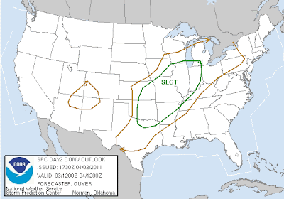
Severe thunderstorms are forecast to first develop across the upper Midwest, from northwest Illinois into southeast Iowa and northern Missouri by late afternoon on Sunday. Below is the latest severe weather outlook for Sunday afternoon and evening from the SPC. The severe weather risk area is outlined in green:


By late Sunday afternoon, a cold front will stretch from the upper Midwest across the central Plains and Rockies. A dryline will extend from a surface low over southcentral Kansas, southward into western portions of Oklahoma and Texas:

Severe thunderstorms are forecast to first develop across the upper Midwest, from northwest Illinois into southeast Iowa and northern Missouri by late afternoon on Sunday. Below is the latest severe weather outlook for Sunday afternoon and evening from the SPC. The severe weather risk area is outlined in green:

Activity is then expected to develop Southward along the cold front over time, reaching portions of western Missouri and eastern Kansas by early evening.
The greatest threat of severe weather, including very large hail and tornadoes, is forecast across the light blue hatched and red outlined regions in the image below:

If thunderstorms are able to develop Southward along the dryline into Oklahoma and northwest Texas, they would also become severe. A strong layer of warm air above ground level (called a capping inversion or "cap") will be in place, which is expected to limit development in this region before sunset.
As the cold front presses further Southward and overtakes the dryline overnight Sunday and into the pre-dawn hours on Monday, additional thunderstorm development is likely across portions of Oklahoma and Texas, as the cap weakens. Since this will occur after dark, the threat of severe weather would be less, but not completely gone away by that time.
The severe weather threat area will spread East and expand into Monday:

No comments:
Post a Comment