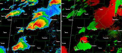
Below are images taken from the Birmingham, AL radar from 4:43 PM to 5:42 PM CDT on Wednesday, April 27, 2011. This covers the period of time that the tornado impacted the Tuscaloosa area. The preliminary NWS ground survey estimates that the tornado initially touched down at about 4:43 PM CDT, to the southwest of Tuscaloosa. The images below will then examine the lifecycle of the storm on radar for approximately 1 hour afterward, including the period of time it was striking Tuscaloosa directly.
The left half of each image shows the radar returns in "reflectivity" mode, which refers to rain, hail, etc. being reflected back to the radar site. The right half of each image shows the radar in "velocity" mode, which refers to the wind speed & direction within a thunderstorm. Remember, when examining the velocity data, reds show wind motion away from the radar, while greens show wind motion toward the radar site. On the images below, the radar site is located toward the right, center portion of the screen, as noted by the "KBMX" in light blue.
Times in both GMT and Central are noted below each image:
21:43 GMT (4:43 PM CDT)
21:47 GMT (4:47 PM CDT)
21:56 GMT (4:56 PM CDT)
22:01 GMT (5:01 PM CDT)
22:05 GMT (5:05 PM CDT)
22:10 GMT (5:10 PM CDT)
22:15 GMT (5:15 PM CDT)
22:19 GMT (5:19 PM CDT)
22:24 GMT (5:24 PM CDT)
22:28 GMT (5:28 PM CDT)
22:33 GMT (5:33 PM CDT)
22:38 GMT (5:38 PM CDT)
22:42 GMT (5:42 PM CDT)
The storm would of course continue on Northeastward and impact the Birmingham area. Detailed radar imagery for that part of the event is forthcoming in a different post.
I didn't want to annotate every single image, that way if you wanted to see a semi-loop by scrolling down the post you could do so. I would, however, like to point out the "debris ball" on at least one of the images. Once identified you can look back and see for yourself how the phenomenon evolved in this particular situation.
On the image below (which is the 22:15 GMT or 5:15 PM CDT shot), I've noted the debris ball with a white circle on the reflectivity side (left half of the image). You can see the brighter, lavender colors right near the center of the classic "hook echo". Unfortunately, this signifies the radar picking up on the substantial debris that is being carried up into the thunderstorm by the tornado.
This illustrates how a large tornado can pick-up and carry debris for miles before eventually throwing it back to the ground. If you ever see this type of signature on a tornadic thunderstorm, you are looking at a very intense circulation that has very recently caused (or is still causing) significant damage.
For more details on the Tuscaloosa area event, please see my background post here, which includes lots of pictures and video of both the tornado and the devastating aftermath.


No comments:
Post a Comment