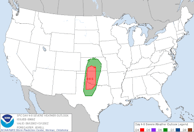
As we would typically start to see in May, a threat of severe weather is forecast to develop on the High Plains of west Texas through western Oklahoma and parts of Kansas later this weekend and into early next week.
The red outlined area on the image above shows the region where severe weather is being forecast by the SPC for Sunday and Monday. The green outlined area shows the expected severe weather threat area for Tuesday.
The combination of an increase in middle and upper level weather disturbances, along with a strong dryline at the surface will create the severe weather threat across the above areas. Large hail, damaging winds and tornadoes will be possible with severe storms that form in these areas.
Of the 3 days with a severe weather risk area being forecast, Tuesday currently looks like the day with the highest threat of possible significant tornado activity. It also looks to me like an "enhanced" threat will exist again on Wednesday for much of the same area outlined in green (even though it is currently not indicated on the above map). Conditions may become even more favorable for stronger tornadoes by that time, so folks living in and near the above areas should pay attention to later updates.

No comments:
Post a Comment