At midday today, a powerful storm system in the middle and upper atmosphere was swirling about over the central and northern Rockies. This system is forecast to lift out to the East/Northeast across the adjacent Plains tonight.
At the surface, an area of low pressure was organizing over the central Rockies. This area of low pressure will move East into the Plains, reaching central Nebraska by 6pm CST and moving into southern Minnesota by dawn on Wednesday. A cold front and dryline will trail the surface low to the South across the Plains.
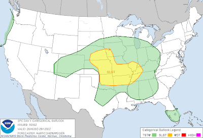
Thunderstorms are forecast to develop along and ahead of these features this evening and tonight, with an attendant risk of severe weather. The latest outlook from the Storm Prediction Center (SPC) in Norman, OK is calling for severe thunderstorm development within the yellow shaded areas on the image below:
The way I currently see this shaping up, there will be 3 distinctive rounds of severe weather potential this evening and/or tonight. Each will carry specific threats and will likely take place during relatively specific periods of time:
First, I expect the initial round of potentially severe thunderstorm activity to develop by mid-evening over southwestern and/or southcentral Nebraska into northcentral Kansas. This would include the cities of Grand Island, Hastings, Russell, Hays and Concordia:
Hail to severe limits (i.e., 1 inch in diameter or larger) will be the primary threat with this activity, which is likely to move and/or develop East/Northeast toward the Missouri River by Midnight. An isolated tornado or two cannot be completely ruled out.
A second area of severe weather is likely to develop Southward along the dryline and/or cold front across eastern Kansas, southeast Nebraska and into eastern Oklahoma later this evening. This would most likely take place after dark, and even more likely after 9pm CST:
Large hail, damaging wind gusts and isolated tornadoes will be possible with this activity. This threat includes the cities of Omaha, Kansas City, Emporia, Ponca City, Enid, Tulsa and Chanute.
Once developed, this activity will progress toward the Eastern edge of the outlook area by Midnight, and pressing further toward the East during the overnight hours, as indicated on this image, which identifies the primary threat area from Midnight through 6am CST Wednesday:
Note that the northern portion of this area will likely see the threat diminish by 3am CST, while the threat will continue further South across southwest Missouri and northwestern through northcentral Arkansas.
Late in the night and toward dawn, I would expect the above activity to congeal into a larger complex of thunderstorms, with large hail and damaging winds the primary threats, which will shift toward the Mississippi River toward dawn on Wednesday:
As you can see, the potential exists for a significant portion of the severe weather threat to take place either after dark and/or after Midnight tonight. If you live in these areas, please make sure that you are prepared to act quickly if threatening weather approaches during the late evening or overnight hours.
Make sure that you have a way to receive weather warnings at night, such as a NOAA Weather Radio with a battery back-up, a smartphone application, text or phone alert service, etc. Be sure to identify your potential sheltering location(s) ahead of time, that way you can quickly move to that area if necessary.
Please...be sure that you never count on outdoor tornado warning sirens to warn you of a threat when inside. As the name implies, they were not designed to provide indoor warnings, and you may not be able to hear them depending on your location relative to the siren, the storm's location, and other factors.
I'll be posting updates on the latest trends this evening, so check back for any significant updates...
If you enjoy reading 'The Original Weather Blog', please be sure to "like" our facebook page!


4 comments:
Even with as cold as it is (44 degrees) and no sun, we're still going to have a tornado risk tonight?? It's not even March yet! Yikes!
Anthill,
I wouldn't be too worried about tornadoes over your way with this one (mainly a wind/hail threat). Can't completely rule it out due to the strength of the wind fields (and the sharp turning of the wind with height), but I certainly wouldn't call it a "tornadoes are likely" situation by any means...
Rob
Thanks, Rob. I guess I'm just not ready to head into "severe weather season" just yet! LOL Keeping an eye on your blog tonight...safe and sound at a hotel in Des Moines because I'm a wimp...and the kids love the pool!
Anthill, consider it a vacation and enjoy the pool. I wouldn't be worried about severe weather up your way...
Rob
Post a Comment