It still appears likely that a swath of light to moderate snow will set-up across portions of the southern Texas panhandle into west-central Texas and possibly east-central New Mexico on Sunday.
The latest run of the SREF computer model is calling for as much as 3-6 inches of snow from near the Lubbock area up to the Northeast between Amarillo and Childress. The forecast image below is valid at 6pm CST on Sunday evening:

The latest run of the SREF computer model is calling for as much as 3-6 inches of snow from near the Lubbock area up to the Northeast between Amarillo and Childress. The forecast image below is valid at 6pm CST on Sunday evening:

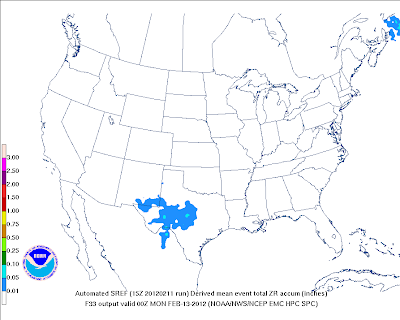
Just South of the snow axis, it appears that a dose of freezing rain may cause some icing problems on Sunday afternoon as well, with up to one-tenth of an inch indicated in the light blue shaded areas on the image below:

A Winter Storm Watch has been posted for the Midland/Odessa area, as well as Carlsbad. Winter Weather Advisories have been posted from Lubbock and Amarillo on up into the eastern part of the Oklahoma panhandle.
At this time it appears that the bulk of the precipitation will take place between Noon and 6pm CST on Sunday across this region. The freezing rain and/or sleet in the South part of the region may continue well into the evening hours on Sunday...
If you have travel plans across the region, be sure to check the latest forecasts and/or weather warnings before heading out on Sunday.
If you enjoy reading 'The Original Weather Blog', please be sure to "like" our facebook page!
No comments:
Post a Comment