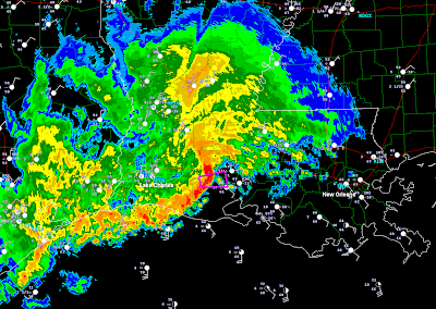
A large area of rain and thunderstorm activity continues to press slowly Eastward from eastern Texas into much of Louisiana and southern Mississippi this morning. The Southern-most end of the complex continues to produce strong to severe thunderstorm activity, particularly with a "bowing" segment of thunderstorms across southern Louisiana at this hour:
The lavender polygon shows where a Tornado Warning is currently in effect at the head of the bowing thunderstorm segment. This activity is moving Eastward at nearly 50 mph.
The severe weather threat will expand Eastward during the day today and into at least early tonight, within the yellow shaded areas on the image below (which is the latest severe weather outlook from the SPC):
Large hail, damaging thunderstorm wind gusts and tornadoes are all possible with severe storms across this region today. The highest risk of damaging winds and tornadoes will correspond with the red shaded area on the following image:
Due to the high moisture content of the air, as well as widespread rainfall across this region, the possibility exists for tornadoes to become "rain wrapped", which may make them very difficult to see (if at all) today. If a storm approaches your area that has a history of producing tornadoes, it would be a very good idea to go ahead and take tornado shelter precautions even if an actual sighting hasn't recently taken place with the storm.
Folks living across this region should remain alert today and listen to NOAA Weather Radio or another trusted source for the latest information, watches and warnings. Review severe weather safety and preparedness tips and have a plan of action, including a sheltering location, in place before severe weather threatens your area.
Very heavy rainfall, which could cause flooding or flash flooding in many areas, will also be a threat from the activity today. The latest rainfall forecast from the HPC calls for widespread rainfall of 2-4 inches with locally higher amounts possible, especially near the purple and red shaded areas on the image below:
If you enjoy reading 'The Original Weather Blog', please be sure to "like" our facebook page!


No comments:
Post a Comment